Al-Shaghour (Arabic: ٱلشَّاغُور, romanized: aš-Šāḡūr) is a municipality and a neighborhood located in the old walled city of Damascus, Syria, south and east of the Old City, and east of al-Midan. Al-Shaghour is one of the oldest recorded neighborhoods in the city.[2] The traditional neighborhood is divided into the part located within the Old City walls, known as Shaghour al-Juwani, and the much larger part located outside the walls. The latter part has become a municipality known as al-Shaghour.
Old al-Shaghour is separated from al-Midan to the west by Al-Beit Street[3] and from Harat al-Yahud (Jewish Quarter) by Al-Ameen Street.[4] The latter, named after a prominent Shiite figure, is the main road in the neighborhood and accommodates the market place and the main shops.[2] Al-Shaghour is also home to many of the prominent Shia Muslim families of Damascus.[2]
History
Shaghour in 1910
During the French mandate, part of the neighborhood, known as "Shaghour al-Juwani" was located within the Old City walls, while most of the neighborhood was located outside the city walls and is known as "Shaghour al-Barrani". The total population of al-Shaghour was 18,715 in 1936, with 34% living in Shaghour al-Juwani and 66% living al-Shaghour al-Barrani. The entire population was Muslim.[5]
Al-Shaghour was a major center of resistance to French rule. Many of its inhabitants were involved in political activism and in the development of Syria's national political thought is the 1930s. Al-Shaghour was the home to several prominent intellectuals and political figures including the famous poet Nizar Qabbani, the minister of defense of the Kingdom of Syria, Yusuf al-Azma,[2] and Hasan al-Kharrat, the most prominent rebel leader in Damascus during the 1925 Great Syrian Revolt.[6]
Districts
By the 21st century, Shaghour al-Barrani evolved to become the larger al-Shaghour Municipality, which in 2004 consisted of the city districts (hayy) of Shaghour al-Barrani (pop. 13,169), al-Bilal (pop. 21,408), al-Zuhur (pop. 37,367), Bab Sharqi (pop. 12,318), al-Wihdah (pop. 29,953), Rawdat al-Midan (pop. 4,887), al-Nidal (pop. 15,588) and Ibn al-Asakir (pop. 4,539).[7][8] Shaghour al-Juwani is located in the Old City municipality and had a population of 2,506 in 2004.[7][8]
References
Asia portal
^"Damascus governorate population 2004 census". Archived from the original on 2017-10-11. Retrieved 2016-12-04.
^ abcdMiller, Catherine (2007). Arabic in the City: Issues in Dialect Contact and Language Variation. Vol. 5. Routledge. p. 192. ISBN 978-0-415-77311-9.
^Stoddart, Brian (2012). A House In Damascus - Before The Fall. Syracuse University Press. p. 129. ISBN 9781614173564.
^Khoury, Philip S. (November 1984). "Syrian Urban Politics in Transition: The Quarters of Damascus during the French Mandate" (PDF). International Journal of Middle East Studies. 16 (4): 510. doi:10.1017/S0020743800028543.
^ ab"Syrian Arab Republic Damascus Governorate Reference map" (PDF). ReliefWeb. United Nations Office for the Coordination of Humanitarian Affairs. 2015-03-16. Retrieved 2016-04-08.
^ ab"The Results of Population and Housing of the 2004 Census: Damascus City". Syria Central Bureau of Statistics. Archived from the original on 2012-08-01. Retrieved 2016-04-08.
Bibliography
Neep, Daniel (2012). Occupying Syria Under the French Mandate: Insurgency, Space and State Formation. Cambridge University Press. ISBN 978-1107000063.
Totah, Faedah M. (2014). Preserving the Old City of Damascus. Syracuse University Press. ISBN 9780815652625.

 Syria
Syria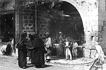
 Asia portal
 Category


