Amasya Province
Province of Turkey
Province in Turkey
Amasya Province Amasya ili | |
|---|---|
Province | |
 Amasya houses | |
 Location of the province within Turkey | |
| Country | Turkey |
| Seat | Amasya |
| Government | |
| • Governor | Yılmaz Doruk |
| Area | 5,628 km2 (2,173 sq mi) |
| Population (2022)[1] | 338,267 |
| • Density | 60/km2 (160/sq mi) |
| Time zone | UTC+3 (TRT) |
| Area code | 0358 |
| Website | www |
Amasya Province (Turkish: Amasya ili) is a province of Turkey, situated on the Yeşil River in the Black Sea Region to the north of the country. Its area is 5,628 km2,[2] and its population is 338,267 (2022).[1]

The provincial capital is Amasya, the antique Amaseia mentioned in documents from the era of Alexander the Great and the birthplace of the geographer and historian Strabo. In Ottoman times Amasya was well known for its madrassas, especially as a centre for the Khalwati Sufi order. The district is also the birthplace of the Ottoman leader Kara Mustafa Pasha.
Demographics
| Year | Pop. | ±% p.a. |
|---|---|---|
| 1927 | 114,884 | — |
| 1935 | 128,113 | +1.37% |
| 1940 | 136,029 | +1.21% |
| 1950 | 163,669 | +1.87% |
| 1960 | 257,281 | +4.63% |
| 1970 | 307,025 | +1.78% |
| 1980 | 341,287 | +1.06% |
| 1990 | 357,191 | +0.46% |
| 2000 | 365,231 | +0.22% |
| 2010 | 334,786 | −0.87% |
| 2020 | 335,494 | +0.02% |
| Source:Turkstat[3][4][5] | ||
Geography
Amasya, between the Black Sea and inner Anatolia, lies at the centre of a region of fertile plains crossed by the Yeşilırmak, Çekerek, and Tersakan rivers. Despite being near the Black Sea, Amasya has hot summers and moderately cold winters. Amasya is an agricultural province known as the best apple growing province in the country, and also producing tobacco, peaches, cherries and okra.[6]
Districts
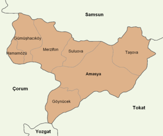
Amasya province is divided into 7 districts (capital district in bold):
References
- ^ a b "Address-based population registration system (ADNKS) results dated 31 December 2022, Favorite Reports" (XLS). TÜİK. Retrieved 19 September 2023.
- ^ "İl ve İlçe Yüz ölçümleri". General Directorate of Mapping. Retrieved 19 September 2023.
- ^ Genel Nüfus Sayımları
- ^ Turkstat
- ^ "The Results of Address Based Population Registration System, 2020". Turkish Statistical Institute. Archived from the original on 2021-10-28. Retrieved 7 December 2021.
- ^ "Amasya". Archived from the original on 2012-05-11. Retrieved 2012-05-14.
External links
- (in English) Pictures of the city of Amasya
- (in English) Amasya Weather Forecast Information
- (in English) Amasya VR Photography
- v
- t
- e
Amasya Province of Turkey

| Istanbul | |
|---|---|
| West Marmara | |
| Aegean | |
| East Marmara | |
| West Anatolia | |
| Mediterranean | |
| Central Anatolia | |
| West Black Sea | |
| East Black Sea | |
| Northeast Anatolia | |
| Central East Anatolia | |
| Southeast Anatolia | |
Metropolitan municipalities are bolded.
Authority control databases | |
|---|---|
| International |
|
| National |
|
| Geographic |
|
40°41′59″N 35°41′11″E / 40.69972°N 35.68639°E / 40.69972; 35.68639
 | This geographical article about a location in Amasya Province, Turkey is a stub. You can help Wikipedia by expanding it. |
- v
- t
- e


