Aubervilliers–Pantin–Quatre Chemins station
Paris Métro station
| Preceding station | Following station | |||
|---|---|---|---|---|
| Porte de la Villette towards Villejuif–Louis Aragon or Mairie d'Ivry | Line 7 | Fort d'Aubervilliers towards La Courneuve–8 mai 1945 | ||
Location | |
|---|---|
  Aubervilliers–Pantin–Quatre Chemins Location within Paris |
Aubervilliers–Pantin–Quatre Chemins (French pronunciation: [obɛʁvilje pɑ̃tɛ̃ katʁ(ə) ʃəmɛ̃]) is a station of the Paris Métro. It is at the crossroads of the Roman road that led from Lutetia to east Flanders (now the N2) and the road between the communes of Aubervilliers and Pantin.
History
Aubervilliers–Pantin–Quatre Chemins opened on 4 October 1979 as part of an extension from Porte de la Villette to Fort d'Aubervilliers.
In 2019, the station was used by 7,215,915 passengers, making it the 37th busiest of the Métro network, out of 302 stations.[1]
In 2020, the station was used by 4,131,018 passengers amidst the COVID-19 pandemic, making it the 27th busiest of the Métro network, out of 305 stations.[2]
Passenger services
Access
The station has 5 entrances along avenue de la République and avenue Jean-Jaurès.
Station layout
| Street Level | ||
| B1 | Mezzanine | |
| Line 7 platforms | Side platform, doors will open on the right | |
| Southbound | ←  | |
| Northbound | → | |
| Side platform, doors will open on the right | ||
Platforms
The station has a standard configuration with 2 tracks surrounded by 2 side platforms.
Other connections
The station is also served by lines 150, 152, 170, and 249 of the RATP bus network, and at night, by line N42 of the Noctilien bus network.
Nearby
- Église Sainte-Marthe des Quatre-Chemins
Gallery
-
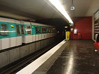 MF 77 at Aubervilliers–Pantin–Quatre Chemins
 -
 One of the entrances of the station


Wikimedia Commons has media related to Aubervilliers - Pantin - Quatre Chemins (Paris Metro).
References
- Roland, Gérard (2003). Stations de métro. D’Abbesses à Wagram. Éditions Bonneton.
- v
- t
- e
| |
| Southern branch | |
|---|---|
| Southeastern branch | |
This article related to the Paris Métro is a stub. You can help Wikipedia by expanding it. |
- v
- t
- e


