Auer Mühlbach
River in Germany
You can help expand this article with text translated from the corresponding article in German. (September 2011) Click [show] for important translation instructions.
- View a machine-translated version of the German article.
- Machine translation, like DeepL or Google Translate, is a useful starting point for translations, but translators must revise errors as necessary and confirm that the translation is accurate, rather than simply copy-pasting machine-translated text into the English Wikipedia.
- Do not translate text that appears unreliable or low-quality. If possible, verify the text with references provided in the foreign-language article.
- You must provide copyright attribution in the edit summary accompanying your translation by providing an interlanguage link to the source of your translation. A model attribution edit summary is
Content in this edit is translated from the existing German Wikipedia article at [[:de:Auer Mühlbach]]; see its history for attribution. - You may also add the template
{{Translated|de|Auer Mühlbach}}to the talk page. - For more guidance, see Wikipedia:Translation.
• location
• coordinates
Auer Mühlbach is a river in Bavaria, Germany. It is a branch of the Isar in the southern part of Munich.
History
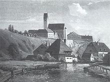
Long before the "official" founding of the city of Munich, the water power of the Isar was used for the operation of mills. Since the Isar was a wild mountain river and until its increasing regulation from the 19th century on, it frequently changed its course and showed strong level fluctuations. The mill wheels in the Munich area were not built at the unpredictable main branch, but at a regulable, artificially diverted side branch with as constant a water flow as possible, the Mühlbach. The first written mention of the stream and a mill at Kiesingenum (today Untergiesing) is found in a document from the year 957.
See also
References
- ^ Complete table of the Bavarian Waterbody Register by the Bavarian State Office for the Environment (xls, 10.3 MB)
Literature (in German)
- Michael Dosch: Projekt zur Isarregulierung und Bebauung der Stadtbezirke Au, München 1897. Monacensia 2° Mon. 59
- Christine Rädlinger: Geschichte der Münchner Stadtbäche. Herausgegeben vom Stadtarchiv München, Franz Schiermeier Verlag München 2004, ISBN 978-3-9809147-2-7
- Peter Klimesch: Drunt in der grünen Au. Die Nockherstraße im Wandel der Zeit. Norderstedt 2014. ISBN 978-3-7357-4929-1.
- v
- t
- e


