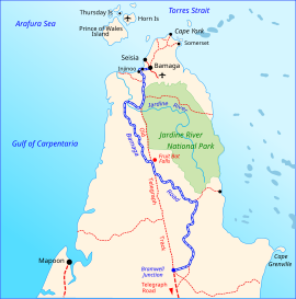
Bamaga Road
Road in Queensland, Australia
Bamaga Road and Telegraph Road Queensland | |
|---|---|
 | |
| Bamaga Road (blue and white) | |
| General information | |
| Type | Road |
| Length | 334 km (208 mi) |
| Major junctions | |
| North end | Bamaga, Queensland (Airport Road) |
| South end | Peninsula Developmental Road (Junction 117 km north of Coen) |
The Bamaga and Telegraph Roads link the Peninsula Developmental Road (PDR), at a junction 117 km (73 mi) north of Coen, with Airport Road in Bamaga, Queensland to the North. The southern part of the road, between PDR junction and Bramwell Junction (114 km (71 mi)), is named Telegraph Road. The northern part of the road between Bramwell Junction and Bamaga (217 km (135 mi)) is named Bamaga Road.[1] The Bamaga and Telegraph Roads are also referred to as the Northern Peninsula Road.[2]
List of towns, localities and points of interest along the highway
- Moreton Telegraph Station
- Bramwell Junction
- Jardine River (Jardine River Ferry)
- Injinoo
Major intersections
This road has no major intersections.
Gallery
-
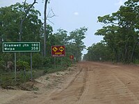 Bamaga Road, also named Northern Peninsula Road, at Jardine River

See also
 Australian Roads portal
 Queensland portal


References
- ^ Hema Maps (2010). Cape York Regional Map (11 ed.). Eight Mile Plains, Qld: Hema Maps. ISBN 978-1-86500-227-9.
- ^ "Remote Community Road Upgrades In Cape York". Nation Building Program. Commonwealth Dept of Infrastructure and Transport. 20 September 2012. Archived from the original on 10 April 2013. Retrieved 26 December 2012.
- v
- t
- e
Road infrastructure in Queensland
Motorways | |
|---|---|
|
National highways | |
|---|---|
Proposals | |
|---|---|


