Cityplace, Dallas
Place in Texas, United States
Cityplace | |
|---|---|
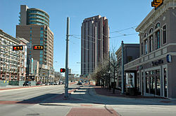 West Village, Mondrian and Tower at Cityplace | |
| Country | United States |
| State | Texas |
| Counties | Dallas |
| City | Dallas |
| Area | |
| • Water | 0 sq mi (0 km2) 0% |
| Area code(s) | 214, 469, 972 |
Cityplace is a TIF District and neighborhood in Old East Dallas, Texas (USA) - near the Uptown area of Dallas, adjacent to the intersection of Central Expressway and Haskell Avenue/Blackburn Street. East of Central Expressway, the neighborhood includes the tree-lined Haskell boulevard and travels past the 42-story Tower at Cityplace. At 42-stories, it is the tallest building in Dallas outside downtown. Also on the east is the newer Cityville high-end apartment complex. The west side Cityplace includes the new-urbanist West Village and the northern end of the Uptown neighborhood.
Tallest Structures
Measuring by structural height, the tallest buildings in the Cityplace neighborhood are as follows:
- Tower at Cityplace 560 feet (171 m)
- The Mondrian
Economy
On June 8, 2009 Dean Foods announced plans to move to the Tower at Cityplace in the first quarter of 2010.[1]
Attractions
Education
Public (DISD)
High schools
- North Dallas High School - AAAAA
Middle schools
- Rusk Middle School
- Alex W. Spence Middle School
Elementary schools
- Houston Elementary School
Private Schools
Holy Trinity Catholic School
Transportation
Streetcars
 MATA: M-Line Trolley

- The M-Line Trolley is a heritage streetcar that provides service between Cityplace/Uptown station in Uptown and St Paul station in Downtown. Service is free.
- The M-Line features 40 dedicated stops serving key destinations including: the West Village, McKinney Avenue, Klyde Warren Park, the Dallas Arts District, four historical cemeteries, and the State Thomas historic neighborhood.
Light rail
 DART: Blue Line, Red Line, and Orange Line

Gallery
-
 Tree-lined Haskell Avenue
 -

-
 West Village
 -

-
 M-Line Trolley at West Village


References
- ^ Hethcock, Bill. "Dean Foods to relocate corporate office." Dallas Business Journal. Monday June 8, 2009. Retrieved on August 2, 2009.
External links
- Cityplace TIF District
- West Village Website
- Historical maps of Cityplace neighborhood, circa 1880-1930 (includes Trolley routes)
- v
- t
- e

- Asian Trade District
- Bishop Arts District
- Casa Linda
- Cedars
- Deep Ellum
- Design District
- Downtown
- Exposition Park
- Fair Park
- Kessler Park
- Knox-Henderson
- Lake Highlands
- Lakewood
- Lower Greenville
- "M" Streets
- Oak Cliff
- Oak Lawn
- Park Cities
- Preston Hollow
- Southwestern Medical District
- Trinity Groves
- Turtle Creek
- Uptown
- Victory Park
- West End

- Pre-1838
- 1839–1855
- 1856–1873
- 1874–1929
- 1930–1945
- 1946–1974
- 1975–1985
- 1986–1995
- 1996–present
- DFW Airport (main hub of American)
- Love Field (main hub of Southwest)
- Freeways
- DART (rapid transit)
- DART Light Rail
- Streetcar
- M-Line Trolley
- North Texas Tollway Authority
- Trinity Railway Express
- All Dallas articles
- Texas Portal
- State of Texas
- North Texas
32°48′25″N 96°47′35″W / 32.807°N 96.793°W / 32.807; -96.793


