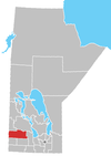
Decker, Manitoba
Place in Manitoba, Canada
50°16′12″N 100°46′54″W / 50.27000°N 100.78167°W / 50.27000; -100.78167 Canada
 Manitoba
R0M 0K0
Decker is an unincorporated community in southwestern Manitoba, Canada. It is located approximately 17 kilometers (10 miles) northwest of Hamiota, Manitoba[2] in the Hamiota Municipality.
The community formed around the Decker family homestead. They arrived there in 1881 and the Post Office opened for the area in 1884 as Arrowton, named for the nearby Arrow River. In 1912 the Post Office was moved to the Decker homestead on 18-15-24W. Nowadays, there is almost nothing left, save for a church, 3 houses and a few old unused shops.[citation needed]
References
- ^ "Population and dwelling counts, for Canada and census subdivisions (municipalities), 2006 and 2001 censuses - 100% data". Statistics Canada, 2006 Census of Population. November 5, 2008. Retrieved January 30, 2009.
- ^ http://www.nrcan.gc.ca/earth-sciences/search/calculate_distance_3_e.php?unique_id_str_1=GAGGY&unique_id_str_2=GBSLL [dead link]
- Geographic Names of Manitoba - Decker (pg. 62) published by the Millenium Bureau of Canada
- v
- t
- e
Division No. 15, Manitoba (Western Manitoba)
| Former towns |
|---|

| Former villages |
|---|
| Former RMs |
|---|
 | This Manitoba location article is a stub. You can help Wikipedia by expanding it. |
- v
- t
- e


