Franconian Rezat
River in Germany
49°25′39″N 10°23′47″E / 49.42750°N 10.39639°E / 49.42750; 10.39639 • location
• coordinates
• elevation
(26.3 % of the catchment) gauge[3]
Average low: 158 L/s (5.6 cu ft/s)
Record high: 60.0 m3/s (2,120 cu ft/s) (in 1941)
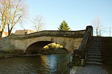
The Markgrafen Bridge at Windsbach
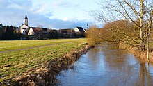
The Franconian Rezat near Wassermungenau

The Franconian Rezat near Georgensgmünd
The Franconian Rezat (German: Fränkische Rezat, pronounced [ˈfʁɛŋkɪʃə ˈʁɛtsat]) is a 77-kilometre-long (48 mi) river in southern Germany.[4] It is the western, left source river of the Rednitz.[5] It rises in the Franconian Heights near Oberdachstetten. It flows generally east through the towns Lehrberg, Ansbach, Windsbach and Spalt. Together with the Swabian Rezat (Schwäbische Rezat), it forms the Rednitz in Georgensgmünd.
See also
References
- ^ TOP 10 Bayern Nord
- ^ a b Complete table of the Bavarian Waterbody Register by the Bavarian State Office for the Environment (xls, 10.3 MB)
- ^ Bayerischer Hochwassernachrichtendienst Archived 2011-05-11 at the Wayback Machine (as at: 6 September 2011)
- ^ Baedeker (Firm), Karl (1907). Southern Germany (Wurtemberg and Bavaria): Handbook for Travellers. K. Baedeker. p. 109.
Franconian Rezat, southern germany.
- ^ "Rednitz - River". RouteYou. Retrieved 2019-11-27.
| Authority control databases |
|
|---|
- v
- t
- e


