Grade II* listed buildings in Denbighshire

Map all coordinates using OpenStreetMap
Download coordinates as:
- KML
- GPX (all coordinates)
- GPX (primary coordinates)
- GPX (secondary coordinates)
In the United Kingdom, the term listed building refers to a building or other structure officially designated as being of special architectural, historical, or cultural significance; Grade II* structures are those considered to be "particularly important buildings of more than special interest".[1] Listing was begun by a provision in the Town and Country Planning Act 1947. Once listed, strict limitations are imposed on the modifications allowed to a building's structure or fittings. In Wales, the authority for listing under the Planning (Listed Buildings and Conservation Areas) Act 1990[2] rests with Cadw.
Buildings
| Name | Location Grid Ref.[note 1] Geo-coordinates | Date Listed | Function | Notes | Reference Number | Image |
|---|---|---|---|---|---|---|
| Plas Newydd | Cefnmeiriadog SJ0000173038 53°14′42″N 3°30′00″W / 53.244931275611°N 3.5000292065208°W / 53.244931275611; -3.5000292065208 (Plas Newydd) | 10 June 1952 | Strikingly located on a rocky rise some 1.6km NW of Cefn Meiriadog village; located immediately W of the lane running NW from Cefn Meiriadog to Glascoed. | 153 |  Upload Photo | |
| Dolbelidr | Cefnmeiriadog SJ0309570921 53°13′35″N 3°27′11″W / 53.226482988895°N 3.453035172109°W / 53.226482988895; -3.453035172109 (Dolbelidr) | 30 January 1968 | Located in a picturesque setting on the S side of the river Elwy at the SE boundary of the community; accessed via a long track running N from Brynwgan farm, itself accessible via a track leading NE from the lane running NE from Henllan to Trefnant. | 176 |  See more images | |
| Perthewig | Trefnant SJ0650871060 53°13′42″N 3°24′07″W / 53.228344817149°N 3.4019685915242°W / 53.228344817149; -3.4019685915242 (Perthewig) | 30 January 1968 | Set in fields approximately 1.5km E of Trefnant village, within a farm group and set back behind cock-and-hen coped rubble forecourt walls; accessed via a long, unmetalled track running W from the road leading to Pont-y-Cambwll. | 224 | Upload Photo | |
| No 1 Llannerch Hall | Trefnant SJ0541472308 53°14′22″N 3°25′07″W / 53.239365362414°N 3.4187220376314°W / 53.239365362414; -3.4187220376314 (No 1 Llannerch Hall) | 6 February 1983 | Set in its own mature parkland at the northern edge of the community, approximately 1km N of Trefnant village; accessed via a long drive running NE from the A 525 St. Asaph to Denbigh Road. | 260 |  | |
| Pont Corweb, Stryd y Bont (Bridge Street) | Corwen SJ0693543370 52°58′47″N 3°23′15″W / 52.979588193981°N 3.3875404100594°W / 52.979588193981; -3.3875404100594 (Pont Corweb, Stryd y Bont (Bridge Street)) | 6 April 1952 | 656 | 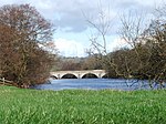 | ||
| Rug, Rug | Corwen SJ0563544054 52°59′08″N 3°24′26″W / 52.985507221275°N 3.407095727255°W / 52.985507221275; -3.407095727255 (Rug, Rug) | 6 April 1952 | 660 | Upload Photo | ||
| Uchel-dref, Ucheldref | Corwen SJ0490445184 52°59′44″N 3°25′06″W / 52.995532402785°N 3.4183136693326°W / 52.995532402785; -3.4183136693326 (Uchel-dref, Ucheldref) | 6 April 1952 | 661 |  | ||
| Gwerclas Hall | Cynwyd SJ0528142135 52°58′06″N 3°24′42″W / 52.968199646907°N 3.4118047166081°W / 52.968199646907; -3.4118047166081 (Gwerclas Hall) | 6 April 1952 | Located approximately 1.5km NW of Cynwyd, and reached by a lane which leads from Pont Dyffrdwy. | 662 | Upload Photo | |
| St Mary's Church | Betws Gwerfil Goch SJ0323646599 53°00′29″N 3°26′37″W / 53.007948754033°N 3.4435813327896°W / 53.007948754033; -3.4435813327896 (St Mary's Church) | 20 October 1966 | At the centre of the village of Bettws Gwerfil Goch, in a square churchyard which is considerably raised above the surrounding land at the SE. Lychgate to north. Rubblestone churchyard wall, partly earth-backed. | 664 |  | |
| Church of St Mael and St Sulien, High Street (South side) | Corwen SJ0788943412 52°58′48″N 3°22′24″W / 52.980130730115°N 3.3733482228326°W / 52.980130730115; -3.3733482228326 (Church of St Mael and St Sulien, High Street (South side)) | 20 December 1966 | 666 |  See more images | ||
| Churchyard Cross, High Street (South side) | Corwen SJ0787343398 52°58′48″N 3°22′25″W / 52.980002162793°N 3.3735824594972°W / 52.980002162793; -3.3735824594972 (Churchyard Cross, High Street (South side)) | 20 October 1966 | 667 |  | ||
| Coleg y Groes (The College), High Street | Corwen SJ0789743377 52°58′47″N 3°22′24″W / 52.979817576505°N 3.3732191327833°W / 52.979817576505; -3.3732191327833 (Coleg y Groes (The College), High Street) | 20 October 1966 | 668 |  | ||
| Corwn Manor (Old Workhouse), Heol Llundain (London Road) (South side) | Corwen SJ0802543366 52°58′47″N 3°22′17″W / 52.979740744274°N 3.371310189216°W / 52.979740744274; -3.371310189216 (Corwn Manor (Old Workhouse), Heol Llundain (London Road) (South side)) | 20 October 1966 | 669 |  See more images | ||
| Pont Melin Rug, Rug | Corwen SJ0507543561 52°58′52″N 3°24′55″W / 52.98097782305°N 3.4152897575276°W / 52.98097782305; -3.4152897575276 (Pont Melin Rug, Rug) | 20 October 1966 | Carries the A5 road over the River Alwen 2km approx. W of Corwen. | 673 | Upload Photo | |
| Blaenddol House | Corwen SJ0271944514 52°59′21″N 3°27′02″W / 52.989118531513°N 3.4506554367882°W / 52.989118531513; -3.4506554367882 (Blaenddol House) | 20 October 1966 | At the extreme north-west of the community, approached off a lane which leaves the main A5 at Pont Melin Rug. | 674 | Upload Photo | |
| Pont Carrog | Corwen SJ1152943711 52°59′00″N 3°19′09″W / 52.983432108295°N 3.3192322059356°W / 52.983432108295; -3.3192322059356 (Pont Carrog) | 20 October 1966 | Carries the minor road from Llidiart y Parc to Carrog over the River Dee. | 675 |  See more images | |
| St Beuno's Church | Gwyddelwern SJ0746946683 53°00′34″N 3°22′50″W / 53.009453256327°N 3.38053917291°W / 53.009453256327; -3.38053917291 (St Beuno's Church) | 20 October 1966 | In the village of Gwyddelwern, to west of the main road. Stone churchyard wall with modern gateway; former schoolroom near entrance. | 676 |  See more images | |
| Plas-yn-Faerdref | Llandrillo SJ0446738793 52°56′17″N 3°25′23″W / 52.938022272227°N 3.4229345748621°W / 52.938022272227; -3.4229345748621 (Plas-yn-Faerdref) | 20 October 1966 | Located off the E side of the road, in a slightly raised position, approx 2km N of Llandrillo. | 697 | Upload Photo | |
| Branas Uchaf | Llandrillo SJ0150737323 52°55′27″N 3°27′59″W / 52.92427646866°N 3.4665156433043°W / 52.92427646866; -3.4665156433043 (Branas Uchaf) | 20 October 1966 | In a fine position overlooking the N banks of the River Dee, approx 2.5km W of Llandrillo. At the end of a track which runs S off a lane which follows the river between Llanderfel and Cynwyd. | 698 | Upload Photo | |
| Ty'n y Llwyn | Cynwyd SJ0627041632 52°57′50″N 3°23′49″W / 52.96385353318°N 3.3969376810026°W / 52.96385353318; -3.3969376810026 (Ty'n y Llwyn) | 20 October 1966 | Located on the hillside above the River Dee, and reached by a track off the E side of the B4401. | 705 | Upload Photo | |
| Pont Dyfrdwy | Cynwyd SJ0530041248 52°57′37″N 3°24′41″W / 52.960232004985°N 3.4112622075431°W / 52.960232004985; -3.4112622075431 (Pont Dyfrdwy) | 20 October 1966 | Located immediately W of Cynwyd village, and carrying a minor road over the River Dee. | 707 |  | |
| Bodidris | Llandegla SJ2048753703 53°04′29″N 3°11′18″W / 53.074638557841°N 3.1883019368954°W / 53.074638557841; -3.1883019368954 (Bodidris) | 28 April 1952 | Approximately 2 km NE of Llandegla, at the end of a narrow lane leading N from the A 5104, occupying a commanding hillside position with a walled garden to north and listed estate buildings to south-west. | 712 | 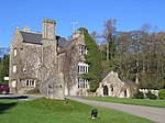 | |
| Plas Ashpool | Llandyrnog SJ1066467804 53°11′59″N 3°20′20″W / 53.199801742669°N 3.3388181412223°W / 53.199801742669; -3.3388181412223 (Plas Ashpool) | 28 April 1952 | To the east side of the B5429, about 2km north of Llandyrnog village; farm buildings to north-west side. | 714 | Upload Photo | |
| Plas-uchaf | Llanfair Dyffryn Clwyd SJ1253852741 53°03′53″N 3°18′24″W / 53.064748653376°N 3.3066581045588°W / 53.064748653376; -3.3066581045588 (Plas-uchaf) | 28 April 1952 | Reached by a minor road and a private drive about 3 km south-south-west of Llanfair Dyffryn Clwyd. | 717 | Upload Photo | |
| Pont Rhyd-y-Cilgwyn | Rhewl SJ1084560385 53°07′59″N 3°20′03″W / 53.133161660185°N 3.3340395273305°W / 53.133161660185; -3.3340395273305 (Pont Rhyd-y-Cilgwyn) | 28 April 1952 | Spanning the river Clywedog immediately W of the main road in the village centre. | 718 | Upload Photo | |
| Bachymbyd Fawr | Llanynys SJ0927461083 53°08′21″N 3°21′28″W / 53.139168610204°N 3.3577115764448°W / 53.139168610204; -3.3577115764448 (Bachymbyd Fawr) | 28 April 1952 | Located approximately 200m SW of the main road on the western slopes of the Vale of Clwyd; accessed via a farm lane. | 719 | Upload Photo | |
| St Tysilio's Church | Bryneglwys SJ1448547368 53°01′00″N 3°16′34″W / 53.016778002037°N 3.2761836569376°W / 53.016778002037; -3.2761836569376 (St Tysilio's Church) | 19 July 1966 | At north side of the village of Bryneglwys, within a hilltop graveyard surrounded by a rubblestone wall; iron gates to south. | 721 | 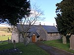 See more images | |
| St Foddhyd's Church | Clocaenog SJ0818854229 53°04′39″N 3°22′19″W / 53.077389463295°N 3.371978671856°W / 53.077389463295; -3.371978671856 (St Foddhyd's Church) | 19 July 1966 | At the west side of the village of Clocaenog. Square churchyard with stone wall to front and to east side overlooking lower ground. | 723 |  See more images | |
| Cross in churchyard of St Mary's Church | Derwen SJ0702750714 53°02′44″N 3°23′18″W / 53.045601008735°N 3.3882877113395°W / 53.045601008735; -3.3882877113395 (Cross in churchyard of St Mary's Church) | 19 July 1966 | Opposite the south porch of St Mary's Church. | 726 | 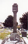 | |
| Derwen Hall | Derwen SJ0929851671 53°03′17″N 3°21′17″W / 53.054591912419°N 3.3546925645029°W / 53.054591912419; -3.3546925645029 (Derwen Hall) | 19 July 1966 | 2 km east of Derwen church. | 729 |  | |
| Parish Church of St Michael and All Angels | Efenechtyd SJ1115555778 53°05′31″N 3°19′41″W / 53.091812430073°N 3.3281306388004°W / 53.091812430073; -3.3281306388004 (Parish Church of St Michael and All Angels) | 19 July 1966 | Located in the village centre within its own rubble-walled churchyard. | 730 |  See more images | |
| Plas-yn-Llan | Efenechtyd SJ1109655688 53°05′28″N 3°19′44″W / 53.090993795969°N 3.3289864666738°W / 53.090993795969; -3.3289864666738 (Plas-yn-Llan) | 19 July 1966 | Set back on the W side of the main village street behind a walled forecourt, at the southern edge of the village group. | 731 |  | |
| Gatepiers and associated Forecourt Walls at Plas-yn-Llan | Efenechtyd SJ1111855680 53°05′27″N 3°19′43″W / 53.090925573323°N 3.3286558405929°W / 53.090925573323; -3.3286558405929 (Gatepiers and associated Forecourt Walls at Plas-yn-Llan) | 19 July 1966 | Enclosing a forecourt in front of Plas-yn-Llan and facing the main village street to the W. | 732 | Upload Photo | |
| St Mary's Church | Cyffylliog SJ0589857834 53°06′34″N 3°24′26″W / 53.109385776436°N 3.4072083564353°W / 53.109385776436; -3.4072083564353 (St Mary's Church) | 19 July 1966 | Located in the centre of the village on the western banks of the Afon Clywedog; sited within its own rubble-walled churchyard featuring several good C18 and C19 chest tombs. | 733 |  See more images | |
| Old Stable Block and Bodidris Cottage to South-west of Bodidris | Llandegla SJ2045253665 53°04′27″N 3°11′20″W / 53.074291827026°N 3.188814829612°W / 53.074291827026; -3.188814829612 (Old Stable Block and Bodidris Cottage to South-west of Bodidris) | 19 July 1966 | Some 100m SW of Bodidris, forming the E side of a courtyard group, bounded to the north by a range which includes Laundry Cottage, Gardener's Cottage and the Barn; to the west by the Bothy and sheltershed; with range of outbuildings to the south. | 746 | Upload Photo | |
| St Tyrnog's Church | Llandyrnog SJ1078465098 53°10′32″N 3°20′11″W / 53.1755046797°N 3.3362658549449°W / 53.1755046797; -3.3362658549449 (St Tyrnog's Church) | 19 July 1966 | In village of Llandyrnog, in a graveyard which now extends beyond a lane to the east; part lost to road widening at west. Stone churchyard wall with steps up at west; war memorial and sundial within the churchyard. | 748 |  See more images | |
| St Cwyfan's Church | Llandyrnog SJ1203366287 53°11′11″N 3°19′04″W / 53.186397916273°N 3.3179119865225°W / 53.186397916273; -3.3179119865225 (St Cwyfan's Church) | 19 July 1966 | In a square churchyard 1.5 km north-east of St Tyrnog's Church. Stone churchyard wall with iron gate at south; modern copy of stocks in an enclosure with iron railings beside the gate; formerly a village pound at north side. | 749 |  See more images | |
| Glan-y-wern Hall | Llandyrnog SJ0988266026 53°11′01″N 3°21′00″W / 53.18369179316°N 3.350018948615°W / 53.18369179316; -3.350018948615 (Glan-y-wern Hall) | 19 July 1966 | 1 km north-west of Llandyrnog village, in parkland to north of the Waen to Denbigh road. | 755 |  | |
| St Elidan's Church | Llanelidan SJ1098850542 53°02′41″N 3°19′45″W / 53.044730594676°N 3.3291736492469°W / 53.044730594676; -3.3291736492469 (St Elidan's Church) | 19 July 1966 | 1 km south of Nantclwyd Hall, in a stone-walled churchyard with iron gate and steps to south; also entered at north by a late-C19 timber-framed lychgate. War memorial cross at west. | 760 | 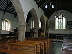 See more images | |
| Nantclwyd Hall | Llanelidan SJ1110851882 53°03′24″N 3°19′40″W / 53.056792716626°N 3.3277544278574°W / 53.056792716626; -3.3277544278574 (Nantclwyd Hall) | 19 July 1966 | 1 km north of Llanelidan church and 200 m east of the A494 Bala to Ruthin road, in the parkland of the C17 house re-landscaped in the C20. | 765 |  See more images | |
| Church of St Cynfarch and St Mary | Llanfair Dyffryn Clwyd SJ1344655478 53°05′22″N 3°17′38″W / 53.08949348882°N 3.2938491814959°W / 53.08949348882; -3.2938491814959 (Church of St Cynfarch and St Mary) | 19 July 1966 | East side of the village of Llanfair Dyffryn Clwyd in a walled churchyard with the stump of a preaching cross; Church House and lychgate to south; iron gates to west. | 767 |  See more images | |
| Jesus Chapel | Llanfair Dyffryn Clwyd SJ1403053714 53°04′25″N 3°17′05″W / 53.073735371534°N 3.2846593223792°W / 53.073735371534; -3.2846593223792 (Jesus Chapel) | 19 July 1966 | Close to the house named Capel-y-gloch, on the east side of the A525 Wrexham Road, 1?km south of Llanfair Dyffryn Clwyd. | 768 |  | |
| Garthgynan | Llanfair Dyffryn Clwyd SJ1427955378 53°05′19″N 3°16′53″W / 53.088729461898°N 3.2813878554476°W / 53.088729461898; -3.2813878554476 (Garthgynan) | 19 July 1966 | Reached by a minor road, about 1km east of Llanfair Dyffryn Clwyd. | 778 | Upload Photo | |
| St Hychan's Church | Llangynhafal SJ1143762134 53°08′56″N 3°19′32″W / 53.14897797288°N 3.3256776244463°W / 53.14897797288; -3.3256776244463 (St Hychan's Church) | 19 July 1966 | At the west side of the B5429, north of the turning to Pont Llanychan. The churchyard is rounded at the north but is otherwise square. | 787 |  See more images | |
| Plas-draw | Llangynhafal SJ1347962264 53°09′02″N 3°17′43″W / 53.150482416343°N 3.2951888945917°W / 53.150482416343; -3.2951888945917 (Plas-draw) | 19 July 1966 | Set back on the east side of the minor road from Llangynhafal to Hirwaen (in Llanbedr). | 789 | Upload Photo | |
| Llanrhaeadr Hall | Llanrhaeadr yng Nghinmeirch SJ0853463487 53°09′38″N 3°22′10″W / 53.16064507887°N 3.3694576876888°W / 53.16064507887; -3.3694576876888 (Llanrhaeadr Hall) | 19 July 1966 | Located approximately 750m E of Llanrhaeadr village and set within its own grounds; accessed via a long, tree-lined and gated drive running NE from the road. | 795 |  | |
| Barn at Pant Glas Isaf | Llanynys SJ0928759582 53°07′32″N 3°21′26″W / 53.125682202554°N 3.3570920863798°W / 53.125682202554; -3.3570920863798 (Barn at Pant Glas Isaf) | 1 October 1970 | Located towards the southern boundary of the community immediately to the N of the present farmhouse; accessed via a short track running W from a lane leading SW from the A 525. | 817 | Upload Photo | |
| Cae'r Afallen | Ruthin SJ1275859618 53°07′36″N 3°18′19″W / 53.126586047785°N 3.3052455958353°W / 53.126586047785; -3.3052455958353 (Cae'r Afallen) | 16 May 1978 | 818 |  See more images | ||
| 51 Clwyd Street | Ruthin SJ1218258166 53°06′48″N 3°18′48″W / 53.11344275949°N 3.3134532209124°W / 53.11344275949; -3.3134532209124 (51 Clwyd Street) | 16 May 1978 | House | 856 | Upload Photo | |
| Porth | Ruthin SJ1214058159 53°06′48″N 3°18′51″W / 53.113372924078°N 3.3140785989039°W / 53.113372924078; -3.3140785989039 (Porth) | 16 May 1978 | 859 | Upload Photo | ||
| The Old Cloisters | Ruthin SJ1235458405 53°06′56″N 3°18′39″W / 53.115618904146°N 3.3109496396497°W / 53.115618904146; -3.3109496396497 (The Old Cloisters) | 24 October 1950 | 908 | Upload Photo | ||
| The Church House (Old Grammar School) | Ruthin SJ1237458437 53°06′57″N 3°18′38″W / 53.115909768256°N 3.3106596599885°W / 53.115909768256; -3.3106596599885 (The Church House (Old Grammar School)) | 24 October 1950 | 910 | Upload Photo | ||
| Castle Hotel | Ruthin SJ1240058299 53°06′53″N 3°18′37″W / 53.114673892971°N 3.3102335952931°W / 53.114673892971; -3.3102335952931 (Castle Hotel) | 24 October 1950 | 917 |  See more images | ||
| Seven Eyes | Ruthin SJ1238858305 53°06′53″N 3°18′37″W / 53.114725838129°N 3.3104144682245°W / 53.114725838129; -3.3104144682245 (Seven Eyes) | 7 April 1966 | 918 | 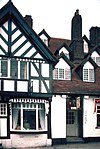 See more images | ||
| North Wales Hospital: Primary Range, including adjoining walled 'Airing Courts' to NW and SE | Denbigh SJ0515865137 53°10′30″N 3°25′14″W / 53.17488052495°N 3.4204233400798°W / 53.17488052495; -3.4204233400798 (North Wales Hospital: Primary Range, including adjoining walled 'Airing Courts' to NW and SE) | 2 February 1981 | Located within its own parkland setting approximately 1km S of Denbigh set back to the W of the lane. | 951 |  | |
| Denbigh Friary | Denbigh SJ0593966562 53°11′16″N 3°24′33″W / 53.18782465286°N 3.4091622096786°W / 53.18782465286; -3.4091622096786 (Denbigh Friary) | 24 October 1950 | Situated at the lower (eastern) end of the town, at the foot of the hill; at the end of the lane, itself leading E off Rhyl Road. | 958 |  See more images | |
| Bronyffynnon aka Hen Cartref | Denbigh SJ0507266109 53°11′01″N 3°25′19″W / 53.183599661779°N 3.4219985169857°W / 53.183599661779; -3.4219985169857 (Bronyffynnon aka Hen Cartref) | 30 November 1966 | Set back slightly from the street behind railed rubble forecourt walls. | 966 |  | |
| Capel Mawr including associated School-room and forecourt railings | Denbigh SJ0524766273 53°11′06″N 3°25′10″W / 53.185104635691°N 3.41942930929°W / 53.185104635691; -3.41942930929 (Capel Mawr including associated School-room and forecourt railings) | 2 February 1981 | Prominently-sited on the corner with Beacon's Hill. | 974 |  | |
| Lon Swan Independent Chapel, including associated Hall, forecourt walls & railings | Denbigh SJ0532466204 53°11′04″N 3°25′06″W / 53.184498327134°N 3.4182569363011°W / 53.184498327134; -3.4182569363011 (Lon Swan Independent Chapel, including associated Hall, forecourt walls & railings) | 2 February 1981 | Set back from the lane behind its own railed, walled forecourt. | 976 |  | |
| Swayne Johnson & Wight, Solicitors Offices | Denbigh SJ0531766130 53°11′02″N 3°25′06″W / 53.183832106674°N 3.4183397069559°W / 53.183832106674; -3.4183397069559 (Swayne Johnson & Wight, Solicitors Offices) | 24 October 1950 | Prominently-sited at the corner with Vale Street. | 979 | Upload Photo | |
| Bull Hotel | Denbigh SJ0531266069 53°11′00″N 3°25′06″W / 53.183283062192°N 3.4183964123817°W / 53.183283062192; -3.4183964123817 (Bull Hotel) | 24 October 1950 | Prominently-sited on the corner with Park Street. | 981 |  | |
| The County Hall (now Denbigh Library) | Denbigh SJ0529666111 53°11′01″N 3°25′07″W / 53.18365762607°N 3.4186482186962°W / 53.18365762607; -3.4186482186962 (The County Hall (now Denbigh Library)) | 24 October 1950 | Prominently-sited at the E end of High Street. | 984 |  | |
| Bryn Celyn | Denbigh SJ0502866167 53°11′03″N 3°25′22″W / 53.184112988788°N 3.4226739806554°W / 53.184112988788; -3.4226739806554 (Bryn Celyn) | 2 February 1981 | Set back from the road behind a curved, narrow forecourt bounded by a hedge. | 985 | Upload Photo | |
| Royles Pharmacy, including adjoining ranges to the rear | Denbigh SJ0528366080 53°11′00″N 3°25′08″W / 53.183376738163°N 3.4188334934523°W / 53.183376738163; -3.4188334934523 (Royles Pharmacy, including adjoining ranges to the rear) | 30 November 1966 | On the street-line. | 1000 | Upload Photo | |
| St Mary's Church | Denbigh SJ0499066139 53°11′02″N 3°25′24″W / 53.183854581097°N 3.4232341085074°W / 53.183854581097; -3.4232341085074 (St Mary's Church) | 2 February 1981 | Prominently located at the Lenten Pool roundabout, set back slightly behind low curving forecourt walls. | 1007 | 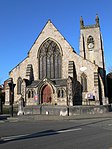 See more images | |
| 1 Park Street | Denbigh SJ0533466090 53°11′01″N 3°25′05″W / 53.183475692628°N 3.4180735360014°W / 53.183475692628; -3.4180735360014 (1 Park Street) | 2 February 1981 | House | Located in the corner at the top of Park Street, adjoining the Bull Hotel. | 1010 | Upload Photo |
| Bryn y Parc | Denbigh SJ0534866085 53°11′00″N 3°25′04″W / 53.183433257393°N 3.417862623407°W / 53.183433257393; -3.417862623407 (Bryn y Parc) | 24 October 1950 | Towards the top of park Street immediately adjacent to No 1; fronting directly onto the road, but with enclosed grounds to NE. | 1011 | Upload Photo | |
| Former House of Thomas Gee, including decorative railings to raised terrace on R | Denbigh SJ0531866166 53°11′03″N 3°25′06″W / 53.184155785092°N 3.4183354241986°W / 53.184155785092; -3.4183354241986 (Former House of Thomas Gee, including decorative railings to raised terrace on R) | 30 November 1966 | On the corner with Chapel Street. | 1022 |  | |
| Y Gelli (formerly Grove House and also Ty Nant) | Denbigh SJ0548566289 53°11′07″N 3°24′57″W / 53.185290825954°N 3.4158735953209°W / 53.185290825954; -3.4158735953209 (Y Gelli (formerly Grove House and also Ty Nant)) | 24 October 1950 | Set back from the road behind a low-walled forecourt. | 1033 | Upload Photo | |
| Pierce's Memorial | Denbigh SJ0562766326 53°11′08″N 3°24′50″W / 53.185648566943°N 3.4137602196075°W / 53.185648566943; -3.4137602196075 (Pierce's Memorial) | 24 October 1950 | Within the Evan Pierce Memorial Garden, set back from the street opposite Somerfield's supermarket; the monument stands in a square, gravelled enclosure with stone kerbing (formerly railed). | 1049 | 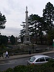 | |
| Foxhall including adjoining Garden and Yard Walls to the SE and SW | Henllan SJ0333567483 53°11′44″N 3°26′54″W / 53.195633088108°N 3.4483987644859°W / 53.195633088108; -3.4483987644859 (Foxhall including adjoining Garden and Yard Walls to the SE and SW) | 24 October 1950 | Located within its own grounds approximately 1.5 km SE of Henllan; accessed via a long track running W from the Denbigh to Henllan road. | 1054 | Upload Photo | |
| Garn | Henllan SJ0249368709 53°12′23″N 3°27′41″W / 53.206495831984°N 3.4613726481437°W / 53.206495831984; -3.4613726481437 (Garn) | 24 October 1950 | Located within its own park at the NW boundary of the community, approximately 1km N of Henllan village; accessed via a drive running N from the road. | 1057 | Upload Photo | |
| Gwaenynog | Denbigh SJ0349865391 53°10′37″N 3°26′43″W / 53.176864024683°N 3.4453273102802°W / 53.176864024683; -3.4453273102802 (Gwaenynog) | 24 October 1950 | Located approximately 1km SW of Denbigh within its own park, set back to the S of the road and accessed via its own drive. | 1058 |  | |
| Lleweni Hall, including Stables to the NE | Denbigh SJ0819968511 53°12′21″N 3°22′33″W / 53.20573440307°N 3.3759111299313°W / 53.20573440307; -3.3759111299313 (Lleweni Hall, including Stables to the NE) | 24 October 1950 | Situated in its own grounds to the north-east of Denbigh, close to the boundary with Aberwheeler Community. Reached by long drives off the lane from Brookhouse to Waen and from the Mold Road. | 1060 | 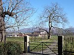 See more images | |
| Carriage Yard to west of Lleweni Hall | Denbigh SJ0802768571 53°12′22″N 3°22′43″W / 53.206243793837°N 3.3785028154698°W / 53.206243793837; -3.3785028154698 (Carriage Yard to west of Lleweni Hall) | 24 October 1950 | On elevated site to west of Lleweni Hall which is situated to the north-east of Denbigh and reached by long drives off the lane from Brookhouse to Waen and from the Mold Road. | 1061 |  | |
| Plas Chambres, including adjoining forecourt and garden walls | Denbigh SJ0468068170 53°12′07″N 3°25′43″W / 53.20204972423°N 3.4284782329664°W / 53.20204972423; -3.4284782329664 (Plas Chambres, including adjoining forecourt and garden walls) | 24 October 1950 | Located towards the western boundary of the community approximately 2km NW of Denbigh; on a sloping site, set back behind a series of ancillary buildings at the cross-roads of the Denbigh to Trefnant road with the lane leading W towards Henllan. | 1063 | Upload Photo | |
| Plas Clough | Denbigh SJ0578867738 53°11′54″N 3°24′42″W / 53.19836556861°N 3.4117685298248°W / 53.19836556861; -3.4117685298248 (Plas Clough) | 24 October 1950 | Located approximately 1.2km N of Denbigh, set back to the W of the Denbigh-St Asaph road on a slight rise and set within its own park. | 1064 | 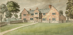 | |
| Plas Heaton | Henllan SJ0310669166 53°12′39″N 3°27′08″W / 53.210714696848°N 3.4523367268477°W / 53.210714696848; -3.4523367268477 (Plas Heaton) | 24 October 1950 | Located within its own park on an elevated site at the northern boundary of the community; accessed via a lodged and gated drive running S from the road. | 1065 | Upload Photo | |
| Parish Church of St Sadwrn including adjacent Cross Shaft | Henllan SJ0223468181 53°12′06″N 3°27′54″W / 53.201703621308°N 3.4650872258367°W / 53.201703621308; -3.4650872258367 (Parish Church of St Sadwrn including adjacent Cross Shaft) | 24 October 1950 | Located at the western perimeter of the village within its own walled churchyard. | 1071 | 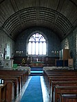 See more images | |
| Detached Belfry Tower at the Church of St Sadwrn | Henllan SJ0226968189 53°12′06″N 3°27′52″W / 53.201781954831°N 3.4645658903729°W / 53.201781954831; -3.4645658903729 (Detached Belfry Tower at the Church of St Sadwrn) | 24 October 1950 | Prominently-sited at the cross-roads, at the NE boundary of the churchyard. | 1073 |  | |
| Plas Newydd | Llangollen SJ2181741719 52°58′02″N 3°09′56″W / 52.967131998469°N 3.1655470354883°W / 52.967131998469; -3.1655470354883 (Plas Newydd) | 24 April 1951 | Set in its own grounds at the top of a secluded glen on the SE edge of the town. Topiary along front wall. Today the main gated entry is near the junction with Bache Mill Road. | 1127 |  See more images | |
| T-shaped range to rear of Pengwern Hall, including vauled undercroft, Pengwern Vale | Llangollen SJ2246641114 52°57′42″N 3°09′21″W / 52.961789045751°N 3.1557409331826°W / 52.961789045751; -3.1557409331826 (T-shaped range to rear of Pengwern Hall, including vauled undercroft, Pengwern Vale) | 24 April 1951 | 1256 | Upload Photo | ||
| Tŷ'n-Dŵr, Tŷ'n-Dŵr Road, Pengwern Vale | Llangollen SJ2315641321 52°57′49″N 3°08′44″W / 52.963748931835°N 3.1455199902281°W / 52.963748931835; -3.1455199902281 (Tŷ'n-Dŵr, Tŷ'n-Dŵr Road, Pengwern Vale) | 22 December 1989 | 1258 | 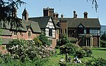 | ||
| Bryn Dethol | Llangollen SJ2393041374 52°57′52″N 3°08′02″W / 52.964335820636°N 3.1340114837876°W / 52.964335820636; -3.1340114837876 (Bryn Dethol) | 30 August 1985 | Situated on hillside south of A5 road, about 2.5 km east of Llangollen, and approached up a steep track through former farmyard. | 1313 | Upload Photo | |
| Llantysilio Hall | Llantysilio SJ1914343685 52°59′04″N 3°12′21″W / 52.984403550915°N 3.2058436108538°W / 52.984403550915; -3.2058436108538 (Llantysilio Hall) | 22 May 1989 | The house is set in 4ha of grounds above the River Dee, NW of Llantysilio Church, on the road from Pentrefelin to Rhewl. It is in the historic township of Maes-yr-ychain and is reached by a driveway from the road. | 1319 |  | |
| Ruthin Castle Hotel | Ruthin SJ1224757976 53°06′42″N 3°18′45″W / 53.111746018804°N 3.3124303949936°W / 53.111746018804; -3.3124303949936 (Ruthin Castle Hotel) | 24 October 1950 | 1347 |  | ||
| Old Rectory | Llanbedr Dyffryn Clwyd SJ1404959832 53°07′43″N 3°17′10″W / 53.128719276095°N 3.2860150543312°W / 53.128719276095; -3.2860150543312 (Old Rectory) | 19 July 1966 | Set in its own grounds approximately 0.5km NW of Llanbedr Dyffryn Clwyd, with drive entrance close to a bend on the road. | 1352 | 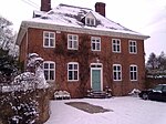 See more images | |
| Faenol Fawr | Bodelwyddan SJ0009076395 53°16′30″N 3°29′59″W / 53.275112976341°N 3.4997512414759°W / 53.275112976341; -3.4997512414759 (Faenol Fawr) | 24 September 1951 | 500m W of the Bodelwyddan to Rhuddlan road, near NW corner of Ysbyty Glan Clwyd. | 1357 |  See more images | |
| Faenol-bach with Domestic Boundary Walls | Bodelwyddan SH9879776245 53°16′25″N 3°31′09″W / 53.273519502037°N 3.5190863115843°W / 53.273519502037; -3.5190863115843 (Faenol-bach with Domestic Boundary Walls) | 24 September 1951 | To S side of an unclassified road from Terfyn to Glan-y-morfa, 1km N of Bodelwyddan School. Domestic site separated from farmyard by a low wall; wall also at entrance | 1358 | Upload Photo | |
| Dyserth Hall | Dyserth SJ0544379820 53°18′25″N 3°25′14″W / 53.306873183779°N 3.4205244406985°W / 53.306873183779; -3.4205244406985 (Dyserth Hall) | 24 September 1951 | At the corner of Ffordd Talargoch and Dyserth Road. Stone-walled forecourt with iron gate and rails; stone-walled drive from road. Garden to S and W, farmyard (now converted to domestic units) to N. | 1360 | Upload Photo | |
| Brynbella | Tremeirchion SJ0819372443 53°14′28″N 3°22′38″W / 53.241067163053°N 3.3771343612812°W / 53.241067163053; -3.3771343612812 (Brynbella) | 24 September 1951 | To south west of Tremeirchion village in extensive private grounds. Approach at east side, landscaped park and garden terracing at west side. | 1373 | Upload Photo | |
| Bach-y-graig Farmhouse | Tremeirchion SJ0752171264 53°13′49″N 3°23′13″W / 53.230355648103°N 3.3868580524764°W / 53.230355648103; -3.3868580524764 (Bach-y-graig Farmhouse) | 24 September 1951 | About 2 km south-west of Tremerchion Parish Church. Bachygraig is approached from the Denbigh side by a private lane starting at Pont-y-Cambwll. Older farmyard buildings at left, terraced lawn at front. | 1374 | Upload Photo | |
| Henblas Hall | Tremeirchion SJ0838071894 53°14′10″N 3°22′27″W / 53.236166099756°N 3.3741750916837°W / 53.236166099756; -3.3741750916837 (Henblas Hall) | 24 September 1951 | At west side of the B5429 Tremeirchion to Bodfari Road, 1 km south of Tremeirchion Parish Church | 1375 |  | |
| Bodeugan Farmhouse | Waen SJ0570774828 53°15′43″N 3°24′54″W / 53.26206236046°N 3.4150805176061°W / 53.26206236046; -3.4150805176061 (Bodeugan Farmhouse) | 24 September 1951 | 2 km east of St Asaph, about 100 m south of the A55, reached by a lane west of the Rhuddlan/Trefnant minor road. | 1376 | Upload Photo | |
| St Margaret's Church, Bodelwyddan (the "Marble Church") | Bodelwyddan SJ0039875460 53°16′00″N 3°29′41″W / 53.266769415898°N 3.4948408853075°W / 53.266769415898; -3.4948408853075 (St Margaret's Church, Bodelwyddan (the "Marble Church")) | 16 November 1962 | At N side of the former St Asaph road now bypassed by the adjacent A55. Low perimeter wall separately listed. | 1377 |  See more images | |
| Gwernigron Dovecote | Bodelwyddan SJ0251975165 53°15′52″N 3°27′47″W / 53.264513347384°N 3.4629607766999°W / 53.264513347384; -3.4629607766999 (Gwernigron Dovecote) | 16 November 1962 | In Gwernigron farmyard. | 1382 |  | |
| Bodelwyddan Castle | Bodelwyddan SH9992374830 53°15′40″N 3°30′06″W / 53.261018882913°N 3.5017616768855°W / 53.261018882913; -3.5017616768855 (Bodelwyddan Castle) | 16 November 1962 | Conspicuously site on rising ground 4km W of St Asaph and 1km S of Bodelwyddan Village, in extensive private grounds enclosed within a perimeter park wall. | 1383 |  | |
| Bodelwyddan Castle Ice House | Bodelwyddan SH9980675027 53°15′46″N 3°30′13″W / 53.262766934057°N 3.5035771223924°W / 53.262766934057; -3.5035771223924 (Bodelwyddan Castle Ice House) | 16 November 1962 | 200m NW of Bodelwyddan Castle and 50m NE of Mine Cottage (in area of car parks). | 1384 | Upload Photo | |
| Pen-isa'r-Glascoed Farmhouse with Garden Wall and Gate | Bodelwyddan SH9929574506 53°15′29″N 3°30′40″W / 53.257988491932°N 3.5110700630965°W / 53.257988491932; -3.5110700630965 (Pen-isa'r-Glascoed Farmhouse with Garden Wall and Gate) | 16 November 1962 | 1385 | Upload Photo | ||
| St Stephen's Church | Bodfari SJ0925470117 53°13′13″N 3°21′38″W / 53.220347850832°N 3.3605778392956°W / 53.220347850832; -3.3605778392956 (St Stephen's Church) | 16 November 1962 | At the centre of Bodfari Village, approached by a lychgate and long flight of steps. The orientation of the church is north east, but conventional orientation is assumed in this description. Stone churchyard wall. | 1386 |  See more images | |
| Church of Saints Mael and Sulien | Cwm SJ0662377465 53°17′09″N 3°24′08″W / 53.285920861397°N 3.4021280627034°W / 53.285920861397; -3.4021280627034 (Church of Saints Mael and Sulien) | 16 November 1962 | In the village of Cwm, 0.5 km east of the Cwm (Dyserth to Rhuallt) road. Stone churchyard wall with gate at west. The Vicarage site encroaches on the churchyard at south, and shares the roadside wall. | 1389 |  | |
| Pentre Cwm | Cwm SJ0618777910 53°17′23″N 3°24′32″W / 53.289842504766°N 3.4087975158026°W / 53.289842504766; -3.4087975158026 (Pentre Cwm) | 16 November 1962 | At the fork of the Cwm Road and the minor road to Marian Cwm, near the southern fringe of the village of Dyserth. Terracing and retaining walls of site much altered in recent restorations. Former farm buildings of Pentre Cwm farm are to the north. | 1391 | Upload Photo | |
| Plas-is-llan | Cwm SJ0543477226 53°17′01″N 3°25′12″W / 53.283562049771°N 3.4198859751016°W / 53.283562049771; -3.4198859751016 (Plas-is-llan) | 16 November 1962 | About 1 km west of Cwm Parish Church. The house faces south to a small stone-walled forecourt, and is flanked by its barns | 1392 | Upload Photo | |
| Pwllhalog farmhouse | Cwm SJ0880577713 53°17′19″N 3°22′10″W / 53.288530004473°N 3.3694795343144°W / 53.288530004473; -3.3694795343144 (Pwllhalog farmhouse) | 16 November 1962 | To the south-east corner of Pwllhalog farmstead, about 2 km east of Cwm Parish Church; the house is within a stone-walled enclosure. | 1393 | Upload Photo | |
| St Bridge's Church, Dyserth | Dyserth SJ0561379387 53°18′11″N 3°25′04″W / 53.303012651105°N 3.4178450893772°W / 53.303012651105; -3.4178450893772 (St Bridge's Church, Dyserth) | 16 November 1962 | At the centre of the village of Dyserth, within a large churchyard. Stone churchyard wall with triangular coping; steel gates to west, north and south. | 1394 |  | |
| Gatepiers of former entrance to Bodwyddan Hall, Bodelwyddan | Rhuddlan SJ0459478578 53°17′44″N 3°25′58″W / 53.295560201242°N 3.4328876435822°W / 53.295560201242; -3.4328876435822 (Gatepiers of former entrance to Bodwyddan Hall, Bodelwyddan) | 16 November 1962 | 1396 | Upload Photo | ||
| St Mary's Church | Rhuddlan SJ0214278098 53°17′27″N 3°28′10″W / 53.290799078194°N 3.4695149910299°W / 53.290799078194; -3.4695149910299 (St Mary's Church) | 16 November 1962 | 1400 |  See more images | ||
| Rhuddlan Bridge | Rhuddlan SJ0217977991 53°17′23″N 3°28′08″W / 53.289844445669°N 3.4689271305106°W / 53.289844445669; -3.4689271305106 (Rhuddlan Bridge) | 16 November 1962 | Spans the river Clwyd to form the only access to the town from the W. | 1402 |  | |
| St Mary's Well, Bodrhyddan | Rhuddlan SJ0450978763 53°17′50″N 3°26′03″W / 53.297207250594°N 3.4342182081625°W / 53.297207250594; -3.4342182081625 (St Mary's Well, Bodrhyddan) | 16 November 1962 | 1403 | Upload Photo | ||
| Main barn at Abbey Farm, Abbey Road (East side) | Rhuddlan SJ0292377484 53°17′08″N 3°27′27″W / 53.285425690677°N 3.4576148718986°W / 53.285425690677; -3.4576148718986 (Main barn at Abbey Farm, Abbey Road (East side)) | 16 November 1962 | 1404 | Upload Photo | ||
| Church of Corpus Christi (Holy Trinity) | Tremeirchion SJ0828273084 53°14′49″N 3°22′34″W / 53.246842718548°N 3.3759859935077°W / 53.246842718548; -3.3759859935077 (Church of Corpus Christi (Holy Trinity)) | 16 November 1962 | In the village of Tremeirchion. The churchyard (extended 1864) is walled in similar stone without coping; gate to west, lychgate to south; war memorial to west. | 1408 |  See more images | |
| Bach-y-graig South East Farm Range | Tremeirchion SJ0746071263 53°13′49″N 3°23′16″W / 53.230336018215°N 3.3877712875386°W / 53.230336018215; -3.3877712875386 (Bach-y-graig South East Farm Range) | 16 November 1962 | In the farmyard of Bach-y-graig | 1412 | Upload Photo | |
| Dovecote at Bodeugan Farm | Waen SJ0567474825 53°15′43″N 3°24′56″W / 53.262029525565°N 3.4155741890894°W / 53.262029525565; -3.4155741890894 (Dovecote at Bodeugan Farm) | 16 November 1962 | In field to west of Bodeugan farmstead | 1418 | Upload Photo | |
| St Thomas's Church | Rhyl SJ0100981514 53°19′17″N 3°29′15″W / 53.321283281127°N 3.4875727087005°W / 53.321283281127; -3.4875727087005 (St Thomas's Church) | 21 June 1949 | Parish church | Prominently sited on the corner with Bath Street. | 1422 |  See more images |
| St Melyd's Church, Meliden | Prestatyn SJ0629381097 53°19′07″N 3°24′29″W / 53.318499589185°N 3.4081500803835°W / 53.318499589185; -3.4081500803835 (St Melyd's Church, Meliden) | 19 June 1950 | In the village of Meliden, at the north junction of Ffordd Talargoch with Meliden Road. | 1424 | 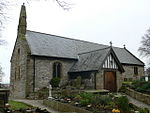 See more images | |
| St Asaph Bridge, High Street | St Asaph SJ0353574243 53°15′23″N 3°26′51″W / 53.256414427504°N 3.4474537653005°W / 53.256414427504; -3.4474537653005 (St Asaph Bridge, High Street) | 16 November 1962 | 1445 | Upload Photo | ||
| St Kentigen and St Asaph's Church, High Street | St Asaph SJ0368774314 53°15′25″N 3°26′43″W / 53.257080086893°N 3.4451976248523°W / 53.257080086893; -3.4451976248523 (St Kentigen and St Asaph's Church, High Street) | 16 November 1962 | Parish church | 1447 |  See more images | |
| The Old Palace, High Street | St Asaph SJ0373174211 53°15′22″N 3°26′40″W / 53.256162538082°N 3.4445071006112°W / 53.256162538082; -3.4445071006112 (The Old Palace, High Street) | 16 November 1962 | 1469 | Upload Photo | ||
| Esgobty farmhouse, Upper Denbigh Road | St Asaph SJ0376674167 53°15′21″N 3°26′38″W / 53.255773518334°N 3.4439693239535°W / 53.255773518334; -3.4439693239535 (Esgobty farmhouse, Upper Denbigh Road) | 16 November 1962 | 1487 | Upload Photo | ||
| Plas yn y pentre | Llangollen SJ2620741393 52°57′53″N 3°06′00″W / 52.964825342106°N 3.1001219140895°W / 52.964825342106; -3.1001219140895 (Plas yn y pentre) | 6 September 1952 | Situated in the Vale of Llangollen on by-road between Trevor and Trevor Uchaf, approximately 1km SW of Pont Cysylltau. | 1546 | 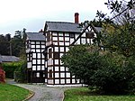 | |
| Terfyn Farmhouse | Cwm SJ0827378210 53°17′34″N 3°22′39″W / 53.29290413237°N 3.3776012485071°W / 53.29290413237; -3.3776012485071 (Terfyn Farmhouse) | 16 November 1962 | About 2 km north-east of Cwm Parish Church | 14645 | Upload Photo | |
| Cowhouse at Abbey Farm, Abbey Road (East side) | Rhuddlan SJ0293477500 53°17′08″N 3°27′27″W / 53.285571481626°N 3.4574548250687°W / 53.285571481626; -3.4574548250687 (Cowhouse at Abbey Farm, Abbey Road (East side)) | 16 November 1962 | 14971 | Upload Photo | ||
| Workshop range at Abbey Farm, Abbey Road (East side) | Rhuddlan SJ0289877489 53°17′08″N 3°27′29″W / 53.285466032376°N 3.4579912673963°W / 53.285466032376; -3.4579912673963 (Workshop range at Abbey Farm, Abbey Road (East side)) | 16 November 1962 | 14972 | Upload Photo | ||
| Churchyard walls, gravestones, chest-tombs and railings at the Church of St Mael and St Sulien | Corwen SJ0793043414 52°58′49″N 3°22′22″W / 52.980155760756°N 3.3727383329674°W / 52.980155760756; -3.3727383329674 (Churchyard walls, gravestones, chest-tombs and railings at the Church of St Mael and St Sulien) | 2 January 1995 | 15513 | Upload Photo | ||
| Attached former farm buildings to Blaenddol house, Blaen y Ddol | Corwen SJ0269744506 52°59′21″N 3°27′04″W / 52.98904263911°N 3.4509806474396°W / 52.98904263911; -3.4509806474396 (Attached former farm buildings to Blaenddol house, Blaen y Ddol) | 20 October 1966 | 15541 | Upload Photo | ||
| Pool Park | Efenechtyd SJ0983255575 53°05′23″N 3°20′52″W / 53.089765929998°N 3.3478233070406°W / 53.089765929998; -3.3478233070406 (Pool Park) | 15 April 1994 | Located at the W boundary of the community, approximately 5km SW of Ruthin; accessed via a long drive running westwards from the road by a lodge. | 16180 |  See more images | |
| St Peter's Church | Llanbedr Dyffryn Clwyd SJ1443759404 53°07′30″N 3°16′48″W / 53.124935492355°N 3.2801035640731°W / 53.124935492355; -3.2801035640731 (St Peter's Church) | 21 December 1995 | At the junction of the A494 and the B 5429, set within its own walled churchyard. | 16593 |  See more images | |
| Holy Trinity Church | Trefnant SJ0499370534 53°13′24″N 3°25′28″W / 53.223348866893°N 3.4244986711534°W / 53.223348866893; -3.4244986711534 (Holy Trinity Church) | 1 September 1998 | Located at the south-western edge of the village, set back within its churchyard to the NW of the Henllan to Trefnant Road. | 19186 |  See more images | |
| No 2 Llannerch Hall | Trefnant SJ0541372310 53°14′22″N 3°25′07″W / 53.239383156009°N 3.4187376109219°W / 53.239383156009; -3.4187376109219 (No 2 Llannerch Hall) | 6 February 1983 | Set in its own mature parkland at the northern edge of the community, approximately 1km N of Trefnant village; accessed via a long drive running NE from the A 525 St. Asaph to Denbigh road. | 19187 | Upload Photo | |
| No 3 Llannerch Hall | Trefnant SJ0541172312 53°14′22″N 3°25′08″W / 53.239400771134°N 3.4187681630146°W / 53.239400771134; -3.4187681630146 (No 3 Llannerch Hall) | 6 February 1983 | Set in its own mature parkland at the northern edge of the community, approximately 1km N of Trefnant village; accessed via a long drive running NE from the A 525 St. Asaph to Denbigh road. | 19188 | Upload Photo | |
| No 4 Llannerch Hall | Trefnant SJ0540972315 53°14′22″N 3°25′08″W / 53.239427372279°N 3.4187990124026°W / 53.239427372279; -3.4187990124026 (No 4 Llannerch Hall) | 6 February 1983 | Set in its own mature parkland at the northern edge of the community, approximately 1km N of Trefnant village; accessed via a long drive running NE from the A 525 St. Asaph to Denbigh road. | 19189 | Upload Photo | |
| No 5 Llannerch Hall | Trefnant SJ0540872317 53°14′22″N 3°25′08″W / 53.239445165864°N 3.4188145857478°W / 53.239445165864; -3.4188145857478 (No 5 Llannerch Hall) | 6 February 1983 | Set in its own mature parkland at the northern edge of the community, approximately 1km N of Trefnant village; accessed via a long drive running NE from the A 525 St. Asaph to Denbigh road. | 19190 | Upload Photo | |
| No 6 Llannerch Hall | Trefnant SJ0540672319 53°14′22″N 3°25′08″W / 53.239462780968°N 3.4188451379164°W / 53.239462780968; -3.4188451379164 (No 6 Llannerch Hall) | 6 February 1983 | Set in its own mature parkland at the northern edge of the community, approximately 1km N of Trefnant village; accessed via a long drive running NE from the A 525 St. Asaph to Denbigh road. | 19191 | Upload Photo | |
| No 7 Llannerch Hall | Trefnant SJ0540572321 53°14′22″N 3°25′08″W / 53.239480574546°N 3.4188607112938°W / 53.239480574546; -3.4188607112938 (No 7 Llannerch Hall) | 6 February 1983 | Set in its own mature parkland at the northern edge of the community, approximately 1km N of Trefnant village; accessed via a long drive running NE from the A 525 St. Asaph to Denbigh road. | 19192 | Upload Photo | |
| No 8 Llannerch Hall | Trefnant SJ0540472323 53°14′22″N 3°25′08″W / 53.239498368122°N 3.4188762846842°W / 53.239498368122; -3.4188762846842 (No 8 Llannerch Hall) | 6 February 1983 | Set in its own mature parkland at the northern edge of the community, approximately 1km N of Trefnant village; accessed via a long drive running NE from the A 525 St. Asaph to Denbigh road. | 19193 | Upload Photo | |
| No 9 Llannerch Hall | Trefnant SJ0540372325 53°14′22″N 3°25′08″W / 53.239516161695°N 3.4188918580876°W / 53.239516161695; -3.4188918580876 (No 9 Llannerch Hall) | 6 February 1983 | Set in its own mature parkland at the northern edge of the community, approximately 1km N of Trefnant village; accessed via a long drive running NE from the A 525 St. Asaph to Denbigh road. | 19194 | Upload Photo | |
| No 10 Llannerch Hall | Trefnant SJ0540272327 53°14′22″N 3°25′08″W / 53.239533955266°N 3.418907431504°W / 53.239533955266; -3.418907431504 (No 10 Llannerch Hall) | 6 February 1983 | Set in its own mature parkland at the northern edge of the community, approximately 1km N of Trefnant village; accessed via a long drive running NE from the A 525 St. Asaph to Denbigh road. | 19195 | Upload Photo | |
| No 111 Llannerch Hall | Trefnant SJ0540172329 53°14′22″N 3°25′08″W / 53.239551748835°N 3.4189230049335°W / 53.239551748835; -3.4189230049335 (No 111 Llannerch Hall) | 6 February 1983 | Set in its own mature parkland at the northern edge of the community, approximately 1km N of Trefnant village; accessed via a long drive running NE from the A 525 St. Asaph to Denbigh road. | 19196 | Upload Photo | |
| No 12 Llannerch Hall | Trefnant SJ0539672311 53°14′22″N 3°25′08″W / 53.239389107866°N 3.4189925475228°W / 53.239389107866; -3.4189925475228 (No 12 Llannerch Hall) | 6 February 1983 | Set in its own mature parkland at the northern edge of the community, approximately 1km N of Trefnant village; accessed via a long drive running NE from the A 525 St. Asaph to Denbigh road. | 19197 | Upload Photo | |
| No 13 Llannerch Hall | Trefnant SJ0539972332 53°14′22″N 3°25′08″W / 53.239578349939°N 3.418953854527°W / 53.239578349939; -3.418953854527 (No 13 Llannerch Hall) | 6 February 1983 | Set in its own mature parkland at the northern edge of the community, approximately 1km N of Trefnant village; accessed via a long drive running NE from the A 525 St. Asaph to Denbigh road. | 19198 | Upload Photo | |
| Dolbelidr | Trefnant SJ0309570926 53°13′36″N 3°27′11″W / 53.226527918463°N 3.4530366935985°W / 53.226527918463; -3.4530366935985 (Dolbelidr) | 1 September 1998 | Located at the NE boundary of the community, approximately 1.2km NE of Trefnant village; sited on the SE side of the unclassified road from Trefnant to Tremeirchion, set back in its own grounds with a large metalled forecourt. | 19212 | Upload Photo | |
| St Tysilio's Church | Llantysilio SJ1941143554 52°59′00″N 3°12′07″W / 52.9832666726°N 3.2018199435365°W / 52.9832666726; -3.2018199435365 (St Tysilio's Church) | 6 July 1963 | The church stands in a very picturesque location set in a walled churchyard above the River Dee and below the road to Rhewl, c3km W of Llangollen. | 19688 |  See more images | |
| Plas-uchaf | Llantysilio SJ2291647979 53°01′25″N 3°09′02″W / 53.023552201598°N 3.1506823382631°W / 53.023552201598; -3.1506823382631 (Plas-uchaf) | 6 September 1952 | The house is set at the head of a narrow valley, on the mountain road to Minera. | 19695 | Upload Photo | |
| Wigfair Hall | Cefnmeiriadog SJ0277771228 53°13′45″N 3°27′28″W / 53.229183446859°N 3.4578906466624°W / 53.229183446859; -3.4578906466624 (Wigfair Hall) | 6 February 1998 | On a commanding site above the Elwy valley at the south-eastern edge of the community, approximately 2km SE of Cefn Meiriadog village; accessed via a tree-lined drive leading S from an unclassified lane running SE from the village. | 19925 |  | |
| Ffynnon Fair | Cefnmeiriadog SJ0291371072 53°13′40″N 3°27′21″W / 53.227806567649°N 3.4558064845496°W / 53.227806567649; -3.4558064845496 (Ffynnon Fair) | 6 February 1998 | Located in a picturesque setting in a field on the N bank of the river Elwy at the SE boundary of the community. | 19933 | Upload Photo | |
| Primary House at Pwll Callod | Efenechtyd SJ1193754254 53°04′42″N 3°18′58″W / 53.078246593924°N 3.31603889671°W / 53.078246593924; -3.31603889671 (Primary House at Pwll Callod) | 25 January 1999 | Located on a rise approximately 800m SE of Pwll-Glas towards the SE boundary of the community. Accessed from the main road via a track running E. The house is sited on a revetted platform above the farmyard, at right-angles to the present farmhouse. | 21225 | Upload Photo | |
| Churchyard Cross Shaft at St Meugan's Church | Llanbedr Dyffryn Clwyd SJ1400057770 53°06′37″N 3°17′10″W / 53.110180779141°N 3.2861937637043°W / 53.110180779141; -3.2861937637043 (Churchyard Cross Shaft at St Meugan's Church) | 24 June 1999 | Located in the churchyard, to the S of the church. | 21925 |  | |
| Ty Mawr | Gwyddelwern SJ0752846711 53°00′35″N 3°22′47″W / 53.009715091087°N 3.3796681406169°W / 53.009715091087; -3.3796681406169 (Ty Mawr) | 11 May 1999 | Aligned with main street of village, about 75m NE of Church of St Beuno. | 22666 |  See more images | |
| Gwasg Gee Printing Works | Denbigh SJ0527066231 53°11′05″N 3°25′09″W / 53.184731322374°N 3.4190727693662°W / 53.184731322374; -3.4190727693662 (Gwasg Gee Printing Works) | 20 July 2000 | On the street-line, the main ranges enclosing a courtyard to the rear. | 23580 |  | |
| Town Hall | Denbigh SJ0522966155 53°11′03″N 3°25′11″W / 53.184041062882°N 3.4196635569444°W / 53.184041062882; -3.4196635569444 (Town Hall) | 20 July 2000 | Prominently sited on the corner of the square with Crown Lane. | 23591 |  | |
| Summerhouse in the garden of Grovehurst | Denbigh SJ0545966348 53°11′09″N 3°24′59″W / 53.185816378945°N 3.4162800273754°W / 53.185816378945; -3.4162800273754 (Summerhouse in the garden of Grovehurst) | 20 July 2000 | In the garden of Grovehurst. | 23606 | Upload Photo | |
| Secondary House at Plas Chambres | Denbigh SJ0469868140 53°12′06″N 3°25′42″W / 53.201783375344°N 3.4281998853521°W / 53.201783375344; -3.4281998853521 (Secondary House at Plas Chambres) | 20 July 2000 | Located immediately SE of the main house on the SW side of the cobbled former service court. | 23649 | Upload Photo | |
| Garthgynan Mill | Llanfair Dyffryn Clwyd SJ1437655141 53°05′12″N 3°16′48″W / 53.086615190949°N 3.2798767005244°W / 53.086615190949; -3.2798767005244 (Garthgynan Mill) | 19 May 2001 | 250 metres south-west of Garthgynon farmhouse, to the west side of the Dwr Ial stream. | 25206 | Upload Photo | |
| Garden Walls with Privy, Pavilion and Cottage at Garthgynan | Llanfair Dyffryn Clwyd SJ1429855357 53°05′19″N 3°16′52″W / 53.088543795734°N 3.2810986311028°W / 53.088543795734; -3.2810986311028 (Garden Walls with Privy, Pavilion and Cottage at Garthgynan) | 19 May 2001 | To south side of Garthgynan farmhouse | 25211 | Upload Photo | |
| Stables at Garthgynan | Llanfair Dyffryn Clwyd SJ1421555386 53°05′20″N 3°16′56″W / 53.088791057251°N 3.2823453380543°W / 53.088791057251; -3.2823453380543 (Stables at Garthgynan) | 19 May 2001 | West of Garthgynan farmhouse, across farm track. | 25216 | Upload Photo | |
| Tomb group in St Bridget's Churchyard | Dyserth SJ0563279380 53°18′11″N 3°25′03″W / 53.302953140666°N 3.4175579856014°W / 53.302953140666; -3.4175579856014 (Tomb group in St Bridget's Churchyard) | 12 October 2001 | About 10 m south-east of the chancel of Dyserth Church. | 25955 |  | |
| Hooded tomb in the churchyard of Saints Mael and Sulien | Cwm SJ0663577463 53°17′09″N 3°24′07″W / 53.285905006956°N 3.4019475322966°W / 53.285905006956; -3.4019475322966 (Hooded tomb in the churchyard of Saints Mael and Sulien) | 1 November 2002 | Adjacent to the south wall of the St Mael & St Sulien's church. | 26087 | Upload Photo | |
| St Beuno's College | Tremeirchion SJ0798974229 53°15′25″N 3°22′51″W / 53.257081069521°N 3.3807069638801°W / 53.257081069521; -3.3807069638801 (St Beuno's College) | 4 September 2002 | On high ground to the east of the B5249 Cwm to Bodfari road | 26459 |  | |
| Candy Mill with Miller's Cottage and Leat | Aberwheeler SJ1082271617 53°14′03″N 3°20′15″W / 53.234093350675°N 3.3375208765843°W / 53.234093350675; -3.3375208765843 (Candy Mill with Miller's Cottage and Leat) | 20 May 2002 | To east of the River Aberwheeler near Ty Draw farm, reached by a minor road from the A541. Leat from the river about 400 m to the north feeding a small pond to its east, the tailwater carried back to the river by an underground culvert to the west. | 26643 | Upload Photo | |
| Faenol Fawr Dovecote | Bodelwyddan SJ0007576397 53°16′30″N 3°30′00″W / 53.275128116108°N 3.4999767317686°W / 53.275128116108; -3.4999767317686 (Faenol Fawr Dovecote) | 24 September 1951 | Attached to rear wing of Faenol Fawr. | 80742 |  | |
| Pont Melin Rug | Cynwyd SJ0504643529 52°58′50″N 3°24′57″W / 52.980685110718°N 3.4157121433928°W / 52.980685110718; -3.4157121433928 (Pont Melin Rug) | 20 October 1966 | Carries the A5 over the River Alwen approx. 2 km W of Corwen. | 82411 | Upload Photo | |
| Ty Gwyn | Ruthin SJ1118157711 53°06′33″N 3°19′42″W / 53.109187827671°N 3.3282776688915°W / 53.109187827671; -3.3282776688915 (Ty Gwyn) | 30 December 2005 | Located in Llanfwrog village, approximately 200m SW of the church. | 87353 |  | |
| Farm outbuildings at Hengoed | Cyffylliog SJ0929758519 53°06′58″N 3°21′24″W / 53.116131315979°N 3.3566417952965°W / 53.116131315979; -3.3566417952965 (Farm outbuildings at Hengoed) | 29 January 2007 | Between Bontuchel and Llanfwrog, about 200m N of bend in minor road. Aligned SW-NE facing farmhouse which is to SE. | 87518 | Upload Photo |
Notes
- ^ Sometimes known as OSGB36, the grid reference is based on the British national grid reference system used by the Ordnance Survey.
See also
 Wales portal

References
External links
![]() Media related to Grade II* listed buildings in Denbighshire at Wikimedia Commons
Media related to Grade II* listed buildings in Denbighshire at Wikimedia Commons
- v
- t
- e
 Architecture
 Wales
Wales


