Grade I listed buildings in Pembrokeshire

Map all coordinates using OpenStreetMap
Download coordinates as:
- KML
- GPX (all coordinates)
- GPX (primary coordinates)
- GPX (secondary coordinates)
This is a list of Grade I-listed buildings in the county of Pembrokeshire, Wales.
In the United Kingdom, the term listed building refers to a building or other structure officially designated as being of special architectural, historical, or cultural significance; Grade I structures are those considered to be "buildings of exceptional interest".[1] Listing was begun by a provision in the Town and Country Planning Act 1947. Once listed, strict limitations are imposed on the modifications allowed to a building's structure or fittings. In Wales,[2] the authority for listing under the Planning (Listed Buildings and Conservation Areas) Act 1990[3] rests with Cadw.
Buildings
| Name | Location Grid Ref.[note 1] Geo-coordinates | Date Listed | Function | Notes | Reference Number | Image |
|---|---|---|---|---|---|---|
| Pele Tower | Angle SM8660702994 51°41′06″N 5°05′18″W / 51.685002246264°N 5.0884378337723°W / 51.685002246264; -5.0884378337723 (Pele Tower) | 14 May 1970 | Pele tower | About 100 m N of St Mary's Church, close to Castle Farm.[4][5] | 5923 |  See more images |
| Caldey Priory, including church and monastery remains | Tenby SS1408596316 51°38′05″N 4°41′16″W / 51.634831481567°N 4.6878826669659°W / 51.634831481567; -4.6878826669659 (Caldey Priory, including church and monastery remains) | 14 May 1970 | Priory | Situated some 300m S of the Abbey, on the W side of the road to the lighthouse.[6][7] | 5932 |  See more images |
| Carew Castle | Carew SN0450003769 51°41′55″N 4°49′49″W / 51.698500981562°N 4.8303804204776°W / 51.698500981562; -4.8303804204776 (Carew Castle) | 14 May 1970 | Castle | At the W of Carew Castle, 600 m N of the A477[8][9] | 5937 | 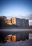 See more images |
| The Carew Cross | Carew SN0467603708 51°41′53″N 4°49′40″W / 51.698014678274°N 4.8278027897843°W / 51.698014678274; -4.8278027897843 (The Carew Cross) | 14 May 1970 | Cross | In Carew village, in a small roadside enclosure taken from Castle Green opposite the Carew Inn.[10][11] | 5938 |  See more images |
| Old Mortuary Chapel | Carew SN0453302831 51°41′24″N 4°49′46″W / 51.690089138599°N 4.8293777654072°W / 51.690089138599; -4.8293777654072 (Old Mortuary Chapel) | 14 May 1970 | Chapel | In St Mary's Churchyard, about 30m NW of the Church.[12][13] | 5945 |  See more images |
| St Michael's Church | Castlemartin SR9106098880 51°38′59″N 5°01′18″W / 51.649745206237°N 5.0216556179063°W / 51.649745206237; -5.0216556179063 (St Michael's Church) | 14 May 1970 | Church | In a lane NW of Castlemartin village.[14][15] | 5948 | 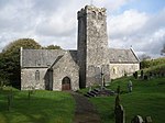 See more images |
| St James's Church | Manorbier SS0650197645 51°38′39″N 4°47′53″W / 51.644200724086°N 4.7980689201978°W / 51.644200724086; -4.7980689201978 (St James's Church) | 14 May 1970 | Church | Dating from the 12th century, the church was granted to Monkton Priory by Sir John de Barri in 1301. Following the Dissolution it became the Parish Church in Manorbier.[16] | 5975 |  See more images |
| Manorbier Castle | Manorbier SS0639597793 51°38′44″N 4°47′59″W / 51.645493225248°N 4.79968091366°W / 51.645493225248; -4.79968091366 (Manorbier Castle) | 14 May 1970 | Castle | Prominently sited at the S end of Manorbier village this early medieval castle was owned by the de Barri family.[17][18] | 5976 | 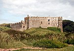 See more images |
| Lydstep Palace | Manorbier SS0863098375 51°39′05″N 4°46′04″W / 51.651487604333°N 4.767736624142°W / 51.651487604333; -4.767736624142 (Lydstep Palace) | 14 May 1970 | Bishop's palace | At N of the A4139 in the centre of Lydstep Village, immediately opposite to Lydstep Tavern.[19][20] | 5991 |  See more images |
| Church Of St Mary | Carew SN0456902804 51°41′23″N 4°49′44″W / 51.689859249631°N 4.8288424824323°W / 51.689859249631; -4.8288424824323 (Church Of St Mary) | 14 May 1970 | Church | In Carew Cheriton, 300m S of the A477.[21][22] | 6007 |  See more images |
| St Elidyr's Church | Stackpole Elidor, Stackpole, Stackpole and Castlemartin SR9872597303 51°38′18″N 4°54′36″W / 51.638391003695°N 4.9101065262818°W / 51.638391003695; -4.9101065262818 (St Elidyr's Church) | 14 May 1970 | Church | Mediaeval church in the hamlet of Cheriton dating to the 12th century or earlier, with restoration by George Gilbert Scott in 1851.[23][24] | 6020 |  See more images |
| Upton Chapel | Cosheston SN0209104699 51°42′22″N 4°51′57″W / 51.706005073458°N 4.8657210817632°W / 51.706005073458; -4.8657210817632 (Upton Chapel) | 14 May 1970 | Chapel | A small chapel in close proximity to Upton Castle. It is reached by a private path from the Castle.[25][26] | 6032 | 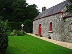 See more images |
| Amroth Castle | Amroth SN1697007241 51°44′02″N 4°39′07″W / 51.733903677124°N 4.6519738112808°W / 51.733903677124; -4.6519738112808 (Amroth Castle) | 4 December 1951 | Country House | At the N side of the unclassified coast road about ? km E of the village of Amroth. A high wall screens the castle grounds from the road, with an entrance archway at the SW corner. A tree-lined drive leads to the Castle.[27][28] | 6041 |  See more images |
| Picton Castle | Slebech SN0107613430 51°47′03″N 4°53′07″W / 51.784046211355°N 4.8853859624894°W / 51.784046211355; -4.8853859624894 (Picton Castle) | 21 June 1971 | Castle | 2 km S of the A40(T) road, in extensive private grounds overlooking the Daugleddau confluence.[29][30] | 6043 |  See more images |
| Llawhaden Castle | Llawhaden SN0730317465 51°49′21″N 4°47′51″W / 51.822468097315°N 4.7974692811161°W / 51.822468097315; -4.7974692811161 (Llawhaden Castle) | 21 June 1971 | Castle | To the W of Llawhaden Village, standing within a wide dry moat, at the head of a steep slope above the Eastern Cleddau.[31][32] | 6065 |  See more images |
| Church of Saint Mary in Liberty | Tenby SN1342400447 51°40′18″N 4°41′59″W / 51.671713308694°N 4.6996277776225°W / 51.671713308694; -4.6996277776225 (Church of Saint Mary in Liberty) | 19 March 1951 | Church | In a prominent position on the SW side of the High Street just NW of Tudor Square.[33][34] | 6177 |  See more images |
| Tudor Merchant's House | Tenby SN1353000440 51°40′18″N 4°41′53″W / 51.671685745827°N 4.6980929209997°W / 51.671685745827; -4.6980929209997 (Tudor Merchant's House) | 19 March 1951 | House | Situated on the W side of Quay Hill facing down Bridge Street.[35][36] | 6226 |  See more images |
| Pembroke Castle | Pembroke SM9816401620 51°40′37″N 4°55′15″W / 51.676953714184°N 4.9206956084913°W / 51.676953714184; -4.9206956084913 (Pembroke Castle) | 2 October 1951 | Castle | Situated prominently at the high W end of the ridge on which the old town of Pembroke is built.[37][38] | 6314 |  See more images |
| Priory Church of Saint Nicholas | Monkton, Pembroke SM9796201451 51°40′31″N 4°55′25″W / 51.675363309528°N 4.9235153718462°W / 51.675363309528; -4.9235153718462 (Priory Church of Saint Nicholas) | 2 October 1951 | Church | In a prominent position in Monkton approximately 200m SW of Pembroke Castle. Now parish church known as St Nicholas & St John, Monkton.[39][40][41] | 6330 | 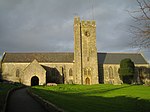 See more images |
| Monkton Old Hall | Monkton, Pembroke SM9805401432 51°40′31″N 4°55′20″W / 51.675225900933°N 4.9221756346237°W / 51.675225900933; -4.9221756346237 (Monkton Old Hall) | 2 October 1951 | Hall | On the N side of Church Terrace in Monkton some 60m E of the Priory Church of Saint Nicholas.[42][43] | 6332 | 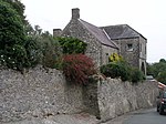 See more images |
| Parish Church of Saint Mary | Pembroke SM9835801540 51°40′35″N 4°55′04″W / 51.676305282553°N 4.9178473688°W / 51.676305282553; -4.9178473688 (Parish Church of Saint Mary) | 2 October 1951 | Church | In a prominent position on the N side of Main Street just E of its junction with Northgate Street.[44][45] | 6400 |  See more images |
| Church of Saint Daniel | Pembroke SM9821200476 51°40′00″N 4°55′10″W / 51.666698513145°N 4.9193412503401°W / 51.666698513145; -4.9193412503401 (Church of Saint Daniel) | 2 October 1951 | In a prominent position on a hill some 1.1km S of Pembroke Castle.[46][47] | 6453 | 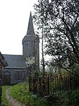 See more images | |
| Narberth Castle | Narberth SN1097814392 51°47′46″N 4°44′33″W / 51.796130042304°N 4.7425342640491°W / 51.796130042304; -4.7425342640491 (Narberth Castle) | 25 September 1951 | Castle | Built soon after 1257, and rebuilt after being burnt in 1299, the castle overlooks the valley and river crossing on the southern approaches to the town[48][49] | 6473 |  See more images |
| St Decuman's Church | Rhoscrowther, Hundleton SM9039502204 51°40′46″N 5°02′00″W / 51.67934146215°N 5.0332480739914°W / 51.67934146215; -5.0332480739914 (St Decuman's Church) | 14 May 1970 | Church | Medieval parish church situated in the centre of the village, with 19th and early 20th century restorations.[50][51] | 6591 |  See more images |
| Tower at Eastington Manor House | Hundleton SM9009702512 51°40′55″N 5°02′16″W / 51.681995121804°N 5.0377372135488°W / 51.681995121804; -5.0377372135488 (Tower at Eastington Manor House) | 14 May 1970 | Farmhouse | Medieval tower house situated 0.75 km NW of Rhoscrowther Church.[52][53] | 6594 |  See more images |
| Ffynone | Manordeifi SN2422338605 52°01′05″N 4°33′47″W / 52.017940473921°N 4.5630325133808°W / 52.017940473921; -4.5630325133808 (Ffynone) | 16 January 1952 | Country House | Country house designed by John Nash, 1792-9 situated 1.5km SE of Newchapel, overlooking Dulas valley. Repaired by W Hoare and Son in 1828 and remodelled by F Inigo Thomas 1902-7.[54][55] | 11980 |  See more images |
| Roch Castle | Roch, Nolton and Roch SM8802921212 51°50′57″N 5°04′44″W / 51.84910498642°N 5.0790178766808°W / 51.84910498642; -5.0790178766808 (Roch Castle) | 13 December 1951 | Castle | Situated in centre of Roch village, on a rocky knoll visible from considerable distances.[56][57] | 11982 | 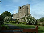 See more images |
| St Michael's Church | Rudbaxton SM9602720561 51°50′47″N 4°57′46″W / 51.846250689277°N 4.9626816243236°W / 51.846250689277; -4.9626816243236 (St Michael's Church) | 1 March 1963 | Church | Situated some 600m E of the A40 in the centre of Rudbaxton just NW of Great Rudbaxton.[58][59] | 12009 | 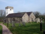 See more images |
| Haverfordwest Castle | Haverfordwest SM9534315728 51°48′09″N 4°58′11″W / 51.802604861847°N 4.9697399165267°W / 51.802604861847; -4.9697399165267 (Haverfordwest Castle) | 12 October 1951 | Castle | Situated on hill in centre of the town.[60][61] | 12031 |  See more images |
| St Mary's Church | Haverfordwest SM9519115569 51°48′04″N 4°58′19″W / 51.801121370591°N 4.9718473569213°W / 51.801121370591; -4.9718473569213 (St Mary's Church) | 12 October 1951 | Church | Situated at the head of the High Street.[62][63] | 12226 |  See more images |
| Remains of Priory of Saint Mary and Saint Thomas the Martyr | Haverfordwest SM9569115219 51°47′53″N 4°57′52″W / 51.798162322961°N 4.9643998172684°W / 51.798162322961; -4.9643998172684 (Remains of Priory of Saint Mary and Saint Thomas the Martyr) | 1 July 1974 | Priory (ruined) | Situated on the riverside at the end of Quay Street.[64][65] | 12240 |  See more images |
| St David's Cathedral | St David's and the Cathedral Close SM7515625430 51°52′55″N 5°16′06″W / 51.881910318675°N 5.2683484460942°W / 51.881910318675; -5.2683484460942 (St David's Cathedral) | 1 March 1963 | Cathedral | The principal cathedral of Wales is built on the site of the monastery founded by Saint David c.520. The present building was built mainly between 1180 and 1220 with numerous additions and restorations.[66][67] | 12537 | 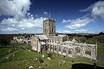 See more images |
| St David's Cathedral Hall (formerly chapel of St Mary's College) and attached cloister ruins | St David's and the Cathedral Close SM7514425474 51°52′56″N 5°16′07″W / 51.882300410337°N 5.26855117324°W / 51.882300410337; -5.26855117324 (St David's Cathedral Hall (formerly chapel of St Mary's College) and attached cloister ruins) | 13 December 1951 | Chapel | Founded 1365 by John of Gaunt and Bishop Adam Houghton, the former chapel of College of Saint Mary is situated on N side of former cathedral cloister, N of cathedral nave.[68][69] | 12538 |  See more images |
| Porth-y-Tŵr, including gateway and South Tower | St Davids and the Cathedral Close SM7520425363 51°52′53″N 5°16′03″W / 51.881328350578°N 5.2676085880808°W / 51.881328350578; -5.2676085880808 (Porth-y-Tŵr, including gateway and South Tower) | 1 March 1963 | Gateway | Large 14th century two-stage octagonal bell-tower and attached gate situated at entrance to The Cathedral Close from The Pebbles and restored in 1929 by W D Caroe.[70][71] | 12541 | 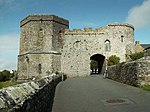 See more images |
| Cloister Hall | St David's and the Cathedral Close SM7517825487 51°52′57″N 5°16′05″W / 51.882430868617°N 5.2680664951354°W / 51.882430868617; -5.2680664951354 (Cloister Hall) | 1 March 1963 | Cloister hall | Situated to N of cathedral in walled enclosure on E side of River Alun, approached by unmetalled track from Treasurer's House.[72][73] | 12553 |  Upload Photo |
| Outbuilding to the north of the Cloister Hall | St David's and the Cathedral Close SM7518525499 51°52′57″N 5°16′05″W / 51.882541416989°N 5.2679727835366°W / 51.882541416989; -5.2679727835366 (Outbuilding to the north of the Cloister Hall) | 1 March 1963 | Outbuilding | Situated to N of cathedral in walled enclosure on E side of River Alun, approached by unmetalled track from Treasurer's House.[74][75] | 12554 | Upload Photo |
| Undercrofts of the former St Mary's Colle, beneath and to the rear of the Cloister Hall | St David's and the Cathedral Close SM7516125496 51°52′57″N 5°16′06″W / 51.882504770272°N 5.2683189357454°W / 51.882504770272; -5.2683189357454 (Undercrofts of the former St Mary's Colle, beneath and to the rear of the Cloister Hall) | 1 March 1963 | Undercroft | Situated to N of cathedral in walled enclosure on E side of River Alun, approached by unmetalled track from Treasurer's House.[76][77] | 12555 | Upload Photo |
| Enclosing wall and gateway on the north side of the rear yard of the Cloister Hall | St David's and the Cathedral Close SM7515925507 51°52′57″N 5°16′06″W / 51.882602698175°N 5.2683551133647°W / 51.882602698175; -5.2683551133647 (Enclosing wall and gateway on the north side of the rear yard of the Cloister Hall) | 1 March 1963 | Wall/Gateway | Situated to N of cathedral in walled enclosure on E side of River Alun, approached by unmetalled track from Treasurer's House.[78][79] | 12556 | Upload Photo |
| Bishop's Palace | St David's and the Cathedral Close SM7502825469 51°52′56″N 5°16′13″W / 51.882208540317°N 5.2702304196862°W / 51.882208540317; -5.2702304196862 (Bishop's Palace) | 1 March 1963 | Bishop's palace | Situated W of the Cathedral on the opposite bank of the River Alun.[80][81] | 12558 |  See more images |
| Ruins of St Justinian's Chapel | St Justinian's SM7231525240 51°52′45″N 5°18′34″W / 51.879047166887°N 5.3094283210591°W / 51.879047166887; -5.3094283210591 (Ruins of St Justinian's Chapel) | 1 March 1963 | Chapel (ruined) | Ruined early 16th century chapel reputedly the burial place of St Justinian.[82][83] | 12692 |  See more images |
| St David's Church | Hubberston, Milford Haven SM8906806233 51°42′54″N 5°03′17″W / 51.715016441932°N 5.054850391453°W / 51.715016441932; -5.054850391453 (St David's Church) | 17 July 1951 | Church | Situated in churchyard behind C20 shops in Gelleswick Road.[84][85] | 12925 |  See more images |
| Newport Castle, Feidr Felin | Newport SN0570838870 52°00′51″N 4°49′58″W / 52.014127074192°N 4.8326642743407°W / 52.014127074192; -4.8326642743407 (Newport Castle, Feidr Felin) | 16 January 1952 | Castle | Anglo-Norman castle situated prominently overlooking town. In 1859 the major surviving part, the gatehouse, was incorporated into a house.[86][87] | 13083 | 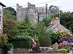 See more images |
| Ruins of St Mary's Abbey, Shinrig | St Dogmaels (part) SN1640445855 52°04′50″N 4°40′51″W / 52.080511295027°N 4.6807443334662°W / 52.080511295027; -4.6807443334662 (Ruins of St Mary's Abbey, Shinrig) | 15 November 1993 | Abbey (ruined) | Ruins of medieval abbey of the Order of Tiron situated to the South of the parish church.[88][89] | 13102 | 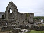 See more images |
| Paterchurch Tower, The Dockyard | Pembroke Dock SM9576303558 51°41′37″N 4°57′23″W / 51.693484302558°N 4.956507736873°W / 51.693484302558; -4.956507736873 (Paterchurch Tower, The Dockyard) | 14 July 1981 | Tower | This medieval tower stood outside the dockyard walls prior to realignment of the walls in 1844.[90][91] | 14341 |  See more images |
| Cilgerran Castle | Cilgerran SN1949843135 52°03′26″N 4°38′03″W / 52.057103422072°N 4.6342049013012°W / 52.057103422072; -4.6342049013012 (Cilgerran Castle) | 15 April 1994 | Castle | 13th century castle situated on a bluff where the Afon Plysgog joins the River Teifi.[92][93] | 14491 |  See more images |
| Stable and kitchen court, Ffynnonau | Manordeifi SN2426738641 52°01′06″N 4°33′45″W / 52.018277790528°N 4.5624104781571°W / 52.018277790528; -4.5624104781571 (Stable and kitchen court, Ffynnonau) | 16 January 1952 | House | Part of the Ffynone estate. The narrow kitchen court is to the immediate East of the house and the larger stable court lies beyond on the North ridge.[94][95] | 15122 | Upload Photo |
| West Tarr Mediaeval House | Penally SN0889600800 51°40′24″N 4°45′55″W / 51.673356571632°N 4.765222792103°W / 51.673356571632; -4.765222792103 (West Tarr Mediaeval House) | 26 April 1996 | House | At the rear of West Tarr farmhouse, 0.5 km SE of St Florence village.[96][97] | 16920 | Upload Photo |
| Whitewell Ruins – structure A | Penally SS0948499060 51°39′29″N 4°45′21″W / 51.657930439143°N 4.7557804918382°W / 51.657930439143; -4.7557804918382 (Whitewell Ruins – structure A) | 14 May 1970 | Manor house (ruined) | At the N side of the A4139 about 1 km E of Lydstep. The ruins are situated at the S of a caravan park behind Whitewell Farm.[98][99] | 6004 | Upload Photo |
| Whitewell Ruins – Structure B | Penally SS0948999035 51°39′28″N 4°45′21″W / 51.657707620188°N 4.7556946655567°W / 51.657707620188; -4.7556946655567 (Whitewell Ruins – Structure B) | 26 April 1996 | Ruin | At the N side of the A4139 about 1 km E of Lydstep. The ruins are situated at the S of a caravan park behind Whitewell Farm.[100][101] | 16922 | Upload Photo |
| Whitewell Ruins – Structure C | Penally SS0947299053 51°39′28″N 4°45′21″W / 51.657863492862°N 4.7559499486243°W / 51.657863492862; -4.7559499486243 (Whitewell Ruins – Structure C) | 26 April 1996 | Ruin | At the N side of the A4139 about 1 km E of Lydstep. The ruins are situated at the S of a caravan park behind Whitewell Farm.[102][103] | 16923 | Upload Photo |
| Sailors' Chapel | Angle SM8663902926 51°41′04″N 5°05′17″W / 51.684403945751°N 5.0879340565568°W / 51.684403945751; -5.0879340565568 (Sailors' Chapel) | 14 May 1970 | Chapel | At N side of St Mary's Church, within the Churchyard.[104][105] | 17147 |  See more images |
| Lamphey Bishop's Palace | Lamphey SN0185000895 51°40′18″N 4°52′01″W / 51.671760370698°N 4.8670436123277°W / 51.671760370698; -4.8670436123277 (Lamphey Bishop's Palace) | 14 May 1970 | Bishop's palace | Reached by minor road at N of Lamphey village.[106][107] | 17393 | 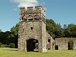 See more images |
| St Govan's Chapel | Stackpole, Stackpole and Castlemartin SR9670592962 51°35′55″N 4°56′12″W / 51.598682365878°N 4.936737789589°W / 51.598682365878; -4.936737789589 (St Govan's Chapel) | 8 February 1996 | Chapel | Early mediaeval chapel built where Saint Govan was believed to have hidden from pirates. The chapel and its well became a pilgrimage site with a reputation for the miraculous cure of lameness and eye-disease.[108][109] | 17980 |  See more images |
| Tenby Town Walls | Tenby SN1334600380 51°40′16″N 4°42′03″W / 51.671085578505°N 4.7007186322418°W / 51.671085578505; -4.7007186322418 (Tenby Town Walls) | 28 March 2002 | Town walls | The walls run W along White Lion Street from corner of Upper Frog St, and then S along South Parade and St Florence Parade to the sea.[110][111] | 26434 |  See more images |
| Wiston Castle | Wiston SN0226118180 51°49′38″N 4°52′15″W / 51.827121083612°N 4.8709400359035°W / 51.827121083612; -4.8709400359035 (Wiston Castle) | 16 June 2004 | Castle | In a prominent position near the centre of Wiston some 200m N of the Church of Saint Mary.[112][113] | 82851 |  See more images |
Notes
- ^ Sometimes known as OSGB36, the grid reference is based on the British national grid reference system used by the Ordnance Survey.
References
- ^ "Buildings & Conservation Areas". Cadw. Retrieved 18 June 2013.
- ^ "Coflein". online database of RCAHMW. Royal Commission on the Ancient and Historical Monuments of Wales. Retrieved 28 November 2016.
- ^ "Planning (Listed Buildings and Conservation Areas) Act 1990". The National Archives. Retrieved 18 June 2013.
- ^ Cadw. "Pele Tower (5923)". National Historic Assets of Wales. Retrieved 4 April 2019.
- ^ "Pele Tower". British Listed Buildings. Retrieved 4 April 2019.
- ^ Cadw. "Caldey Priory, including church and monastery remains (5932)". National Historic Assets of Wales. Retrieved 4 April 2019.
- ^ "Caldey Priory, including church and monastery remains". British Listed Buildings. Retrieved 4 April 2019.
- ^ Cadw. "Carew Castle (5937)". National Historic Assets of Wales. Retrieved 4 April 2019.
- ^ "Carew Castle". British Listed Buildings. Retrieved 4 April 2019.
- ^ Cadw. "The Carew Cross (5938)". National Historic Assets of Wales. Retrieved 4 April 2019.
- ^ "The Carew Cross". British Listed Buildings. Retrieved 4 April 2019.
- ^ Cadw. "Old Mortuary Chapel (5945)". National Historic Assets of Wales. Retrieved 4 April 2019.
- ^ "Old Mortuary Chapel". British Listed Buildings. Retrieved 4 April 2019.
- ^ Cadw. "Church of St. Michael (5948)". National Historic Assets of Wales. Retrieved 4 April 2019.
- ^ "Church of St. Michael". British Listed Buildings. Retrieved 4 April 2019.
- ^ Cadw. "St James' Church (5975)". National Historic Assets of Wales. Retrieved 4 April 2019.
- ^ Cadw. "Manorbier Castle (5976)". National Historic Assets of Wales. Retrieved 4 April 2019.
- ^ "Manorbier Castle". British Listed Buildings. Retrieved 4 April 2019.
- ^ Cadw. "early complete medieval castle (5991)". National Historic Assets of Wales. Retrieved 4 April 2019.
- ^ "early complete medieval castle". British Listed Buildings. Retrieved 4 April 2019.
- ^ Cadw. "Church Of St. Mary (6007)". National Historic Assets of Wales. Retrieved 4 April 2019.
- ^ "Church Of St. Mary". British Listed Buildings. Retrieved 4 April 2019.
- ^ Cadw. "St. Elidyr's Church (6020)". National Historic Assets of Wales. Retrieved 4 April 2019.
- ^ "St. Elidyr's Church". British Listed Buildings. Retrieved 4 April 2019.
- ^ Cadw. "Upton Chapel (6032)". National Historic Assets of Wales. Retrieved 4 April 2019.
- ^ "Upton Chapel". British Listed Buildings. Retrieved 4 April 2019.
- ^ Cadw. "Amroth Castle (6041)". National Historic Assets of Wales. Retrieved 4 April 2019.
- ^ "Amroth Castle". British Listed Buildings. Retrieved 4 April 2019.
- ^ Cadw. "Picton Castle (6043)". National Historic Assets of Wales. Retrieved 4 April 2019.
- ^ "Picton Castle". British Listed Buildings. Retrieved 4 April 2019.
- ^ Cadw. "Llawhaden Castle (6065)". National Historic Assets of Wales. Retrieved 4 April 2019.
- ^ "Llawhaden Castle". British Listed Buildings. Retrieved 4 April 2019.
- ^ Cadw. "Church of Saint Mary in Liberty (6177)". National Historic Assets of Wales. Retrieved 4 April 2019.
- ^ "Church of Saint Mary in Liberty". British Listed Buildings. Retrieved 4 April 2019.
- ^ Cadw. "The Tudor Merchant's House (6226)". National Historic Assets of Wales. Retrieved 4 April 2019.
- ^ "The Tudor Merchant's House". British Listed Buildings. Retrieved 4 April 2019.
- ^ Cadw. "Pembroke Castle (6314)". National Historic Assets of Wales. Retrieved 4 April 2019.
- ^ "Pembroke Castle". British Listed Buildings. Retrieved 4 April 2019.
- ^ Cadw. "Priory Church of Saint Nicholas (6330)". National Historic Assets of Wales. Retrieved 4 April 2019.
- ^ "Priory Church of Saint Nicholas". British Listed Buildings. Retrieved 4 April 2019.
- ^ "Benefice of South West Pembrokeshire". Retrieved 23 February 2021.
- ^ Cadw. "Monkton Old Hall (6332)". National Historic Assets of Wales. Retrieved 4 April 2019.
- ^ "Monkton Old Hall". British Listed Buildings. Retrieved 4 April 2019.
- ^ Cadw. "Parish Church of Saint Mary (6400)". National Historic Assets of Wales. Retrieved 4 April 2019.
- ^ "Parish Church of Saint Mary". British Listed Buildings. Retrieved 4 April 2019.
- ^ Cadw. "Church of Saint Daniel (6453)". National Historic Assets of Wales. Retrieved 4 April 2019.
- ^ "Church of Saint Daniel". British Listed Buildings. Retrieved 4 April 2019.
- ^ Cadw. "Narbeth Castle (6473)". National Historic Assets of Wales. Retrieved 4 April 2019.
- ^ "Narbeth Castle". British Listed Buildings. Retrieved 4 April 2019.
- ^ Cadw. "Church of St Decumanus (6591)". National Historic Assets of Wales. Retrieved 4 April 2019.
- ^ "Church of St Decumanus". British Listed Buildings. Retrieved 4 April 2019.
- ^ Cadw. "The Tower at Eastington Manor House (6594)". National Historic Assets of Wales. Retrieved 4 April 2019.
- ^ "The Tower at Eastington Manor House". British Listed Buildings. Retrieved 4 April 2019.
- ^ Cadw. "Ffynone (11980)". National Historic Assets of Wales. Retrieved 4 April 2019.
- ^ "Ffynone". British Listed Buildings. Retrieved 4 April 2019.
- ^ Cadw. "Roch Castle (11982)". National Historic Assets of Wales. Retrieved 4 April 2019.
- ^ "Roch Castle". British Listed Buildings. Retrieved 4 April 2019.
- ^ Cadw. "Church of Saint Michael (12009)". National Historic Assets of Wales. Retrieved 4 April 2019.
- ^ "Church of Saint Michael". British Listed Buildings. Retrieved 4 April 2019.
- ^ Cadw. "Haverfordwest Castle (12031)". National Historic Assets of Wales. Retrieved 4 April 2019.
- ^ "Haverfordwest Castle". British Listed Buildings. Retrieved 4 April 2019.
- ^ Cadw. "Church of Saint Mary (12226)". National Historic Assets of Wales. Retrieved 4 April 2019.
- ^ "Church of Saint Mary". British Listed Buildings. Retrieved 4 April 2019.
- ^ Cadw. "Remains of Priory of Saint Mary and Saint Thomas the Martyr (12240)". National Historic Assets of Wales. Retrieved 4 April 2019.
- ^ "Remains of Priory of Saint Mary and Saint Thomas the Martyr". British Listed Buildings. Retrieved 4 April 2019.
- ^ Cadw. "Cathedral of St Davids (12537)". National Historic Assets of Wales. Retrieved 4 April 2019.
- ^ "Cathedral of St Davids". British Listed Buildings. Retrieved 4 April 2019.
- ^ Cadw. "St David's Cathedral Hall (formerly Chapel of St Mary's College) & attached Cloister Ruins (12538)". National Historic Assets of Wales. Retrieved 4 April 2019.
- ^ "St David's Cathedral Hall (formerly Chapel of St Mary's College) & attached Cloister Ruins". British Listed Buildings. Retrieved 4 April 2019.
- ^ Cadw. "Porth-y-Twr, including Gateway & South Tower (12541)". National Historic Assets of Wales. Retrieved 4 April 2019.
- ^ "Porth-y-Twr, including Gateway & South Tower". British Listed Buildings. Retrieved 4 April 2019.
- ^ Cadw. "Cloister Hall (12553)". National Historic Assets of Wales. Retrieved 4 April 2019.
- ^ "Cloister Hall". British Listed Buildings. Retrieved 4 April 2019.
- ^ Cadw. "Outbuilding to N. of The Cloister Hall (12554)". National Historic Assets of Wales. Retrieved 4 April 2019.
- ^ "Outbuilding to N. of The Cloister Hall". British Listed Buildings. Retrieved 4 April 2019.
- ^ Cadw. "Undercrofts of former St Mary's College, beneath & to the rear of The Cloister Hall (12555)". National Historic Assets of Wales. Retrieved 4 April 2019.
- ^ "Undercrofts of former St Mary's College, beneath & to the rear of The Cloister Hall". British Listed Buildings. Retrieved 4 April 2019.
- ^ Cadw. "Enclosing Wall & Gateway on N.Side of rear yard of Cloister Hall (12556)". National Historic Assets of Wales. Retrieved 4 April 2019.
- ^ "Enclosing Wall & Gateway on N.Side of rear yard of Cloister Hall". British Listed Buildings. Retrieved 4 April 2019.
- ^ Cadw. "The Bishop's Palace (12558)". National Historic Assets of Wales. Retrieved 4 April 2019.
- ^ "The Bishop's Palace". British Listed Buildings. Retrieved 4 April 2019.
- ^ Cadw. "Ruins of St Justinian's Chapel (12692)". National Historic Assets of Wales. Retrieved 4 April 2019.
- ^ "Ruins of St Justinian's Chapel". British Listed Buildings. Retrieved 4 April 2019.
- ^ Cadw. "Church of St David (12925)". National Historic Assets of Wales. Retrieved 4 April 2019.
- ^ "Church of St David". British Listed Buildings. Retrieved 4 April 2019.
- ^ Cadw. "Newport Castle (13083)". National Historic Assets of Wales. Retrieved 4 April 2019.
- ^ "Newport Castle". British Listed Buildings. Retrieved 4 April 2019.
- ^ Cadw. "Ruins of Abbey of St Mary (13102)". National Historic Assets of Wales. Retrieved 4 April 2019.
- ^ "Ruins of Abbey of St Mary". British Listed Buildings. Retrieved 4 April 2019.
- ^ Cadw. "Paterchurch Tower (14341)". National Historic Assets of Wales. Retrieved 4 April 2019.
- ^ "Paterchurch Tower". British Listed Buildings. Retrieved 4 April 2019.
- ^ Cadw. "Cilgerran Castle (14491)". National Historic Assets of Wales. Retrieved 4 April 2019.
- ^ "Cilgerran Castle". British Listed Buildings. Retrieved 4 April 2019.
- ^ Cadw. "Stable and Kitchen Court (15122)". National Historic Assets of Wales. Retrieved 4 April 2019.
- ^ "Stable and Kitchen Court". British Listed Buildings. Retrieved 4 April 2019.
- ^ Cadw. "West Tarr Mediaeval House (16920)". National Historic Assets of Wales. Retrieved 4 April 2019.
- ^ "West Tarr Mediaeval House". British Listed Buildings. Retrieved 4 April 2019.
- ^ Cadw. "Whitewell Ruins - structure A (6004)". National Historic Assets of Wales. Retrieved 4 April 2019.
- ^ "Whitewell Ruins - structure A". British Listed Buildings. Retrieved 4 April 2019.
- ^ Cadw. "Whitewell Ruins - Structure B (16922)". National Historic Assets of Wales. Retrieved 4 April 2019.
- ^ "Whitewell Ruins - Structure B". British Listed Buildings. Retrieved 4 April 2019.
- ^ Cadw. "Whitewell Ruins - Structure C (16923)". National Historic Assets of Wales. Retrieved 4 April 2019.
- ^ "Whitewell Ruins - Structure C". British Listed Buildings. Retrieved 4 April 2019.
- ^ Cadw. "Sailors' Chapel (17147)". National Historic Assets of Wales. Retrieved 4 April 2019.
- ^ "Sailors' Chapel". British Listed Buildings. Retrieved 4 April 2019.
- ^ Cadw. "Lamphey Bishop's Palace (17393)". National Historic Assets of Wales. Retrieved 4 April 2019.
- ^ "Lamphey Bishop's Palace". British Listed Buildings. Retrieved 4 April 2019.
- ^ Cadw. "St. Govan's Chapel (17980)". National Historic Assets of Wales. Retrieved 5 April 2019.
- ^ "St. Govan's Chapel". British Listed Buildings. Retrieved 5 April 2019.
- ^ Cadw. "Tenby Town Walls (26434)". National Historic Assets of Wales. Retrieved 5 April 2019.
- ^ "Tenby Town Walls". British Listed Buildings. Retrieved 5 April 2019.
- ^ Cadw. "Wiston Castle (82851)". National Historic Assets of Wales. Retrieved 4 April 2019.
- ^ "Wiston Castle". British Listed Buildings. Retrieved 5 April 2019.
See also
 Wales portal

- Grade II* listed buildings in Pembrokeshire
- Listed buildings in Wales
- Scheduled monuments in Pembrokeshire
- Registered historic parks and gardens in Pembrokeshire
External links
![]() Media related to Grade I listed buildings in Pembrokeshire at Wikimedia Commons
Media related to Grade I listed buildings in Pembrokeshire at Wikimedia Commons
- v
- t
- e
 Architecture
 Wales
Wales


