Honey Run Covered Bridge
United States historic place
Honey Run Covered Bridge | |
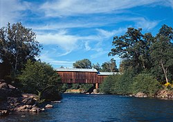 A picture from the Historic American Engineering Record | |
39°43′43″N 121°42′13″W / 39.72861°N 121.70361°W / 39.72861; -121.70361 | |
| Built | 1886 |
|---|---|
| Architect | American Bridge and Building Company of San Francisco |
| Demolished | 2018 |
| Restored | Planned for 2022[1] |
| Restored by | Honey Run Covered Bridge Association (HRCBA) |
| NRHP reference No. | 88000920 |
| Added to NRHP | June 23, 1988[2] |
Honey Run Covered Bridge was a wooden covered bridge crossing Butte Creek, in Butte County, northern California in the United States. It was located on Honey Run Road at Centerville Road, about halfway in between Chico and Paradise, until it was destroyed in the Camp Fire on November 8, 2018.[3]
History
Built in 1886 and accepted as completed by the Butte County Board of Supervisors on January 3, 1887, the Honey Run Bridge (originally Carr Hill Bridge) was constructed by the American Bridge and Building Company of San Francisco. George Miller was appointed Superintendent of Construction by Butte County to oversee the project.

The three-span wooden bridge was originally built uncovered, as evidenced by the timber trusses of the two original, remaining spans covered with sheet metal on three sides. The cover was added in 1901.
Crossing Butte Creek, the Honey Run Bridge was the only surviving example of a three-span timber Pratt-type covered bridge in the United States. It was listed on the National Register of Historic Places in 1988.[2]
The bridge was open to vehicular traffic until a truck crashed into the eastern span and damaged it in 1965, thus making the bridge virtually impassable. A new steel bridge was built upstream for vehicular traffic.
The covered bridge was then used as a pedestrian footbridge, protected within Honey Run Covered Bridge County Park. Local residents raised funds and rebuilt the eastern span from the ruins, and the bridge re-opened in 1972.[4]
It was destroyed by the Camp Fire on November 8, 2018.[5] There is a possibility that Historic American Engineering Record documentation of the bridge could be used in its reconstruction.[6]
See also
- List of bridges documented by the Historic American Engineering Record in California
- National Register of Historic Places listings in Butte County, California
References
- ^ "ABOUT HONEY RUN COVERED BRIDGE". HRCBA.
- ^ a b "National Register Information System". National Register of Historic Places. National Park Service. April 15, 2008.
- ^ Robertson, Michelle (2018-11-10). "132-year-old Honey Run Covered Bridge, the last of its kind, destroyed by wildfire". SFGate. Retrieved 2018-11-10.
- ^ Miller, Terry E. (25 March 2014). America's Covered Bridges. Tuttle. ISBN 9781462914203.
- ^ "Camp Fire in Paradise as Wildfire destroyed Buildings". November 2018.
- ^ *Witcher, T. R. (January 2019). "Fifty Years of Preservation: The Historic American Engineering Record" (PDF). Civil Engineering.
External links
Wikimedia Commons has media related to Honey Run Covered Bridge.
- Honey Run Covered Bridge
- Historic American Engineering Record (HAER) No. CA-312, "Honey Run Bridge, Spanning Butte Creek, bypassed section of Honey Run Road (originally Carr Hill Road), Paradise vicinity, Butte County, CA", 18 photos, 2 color transparencies, 9 measured drawings, 15 data pages, 2 photo caption pages
- v
- t
- e
Municipalities and communities of Butte County, California, United States
County seat: Oroville
- Biggs
- Chico
- Gridley
- Oroville
- Paradise

communities
‡This populated place also has portions in an adjacent county or counties
- California portal
- United States portal

 | This article about a property in Butte County, California on the National Register of Historic Places is a stub. You can help Wikipedia by expanding it. |
- v
- t
- e
 | This article about a bridge in California is a stub. You can help Wikipedia by expanding it. |
- v
- t
- e


