Houayxay
District & municipality in Bokeo Province, Laos
Houayxay 20°15′47″N 100°26′1″E / 20.26306°N 100.43361°E / 20.26306; 100.43361 | |
|---|---|
| Country |  Laos Laos |
| Admin. division | Bokeo Province |
| Elevation | 398 m (1,306 ft) |
| Population (2015)[1] | |
| • Total | 70,200 |
| • Religions | Buddhism |
| Time zone | UTC+7 (ICT) |
| Climate | Aw |
Houayxay (Lao: ຫ້ວຍຊາຍ, pronounced [hȕa̯j sáːj]) (also Huoeisay, Houei Sai or Huay Xai), is a district in Bokeo Province, Laos, on the border with Thailand. Ban Houayxay is the administrative centre of the district.
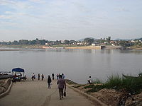
The town lies on the Mekong River opposite Chiang Khong in Thailand. The Fourth Thai-Lao Friendship Bridge at Ban Houayxay, which opened in December 2013 and replaced ferry service across the river, is now the northernmost road border crossing between the two countries. Asian Highway 3, which runs through Ban Houayxay, extends north to Yunnan Province of China and south to Chiang Rai Province of Thailand.
Houayxay has a domestic airport (HOE) with regular flights to Vientiane and Luang Prabang (depending on the season).
The town is the starting point for many boats (speed and slow boats, freighters, luxury cruisers for tourists and others) on the Mekong River to Pakbeng, Luang Prabang and other destinations.[2]
Houayxay is also home to the Gibbon Experience,[3] another highlight for tourists. It is a series of ziplines and treehouses providing a unique overnight experience.[4]
Fort Carnot, an ancient French fort in ruins, sits on a hill overlooking the town and the Mekong River.
-
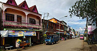 Town centre
 -
 Stairs to the hill of the temple
 -
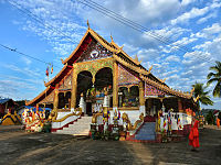 Vat Chom Khao Manilat
 -
 Border crossing to Thailand


Climate
| Climate data for Houayxay (1990–2019) | |||||||||||||
|---|---|---|---|---|---|---|---|---|---|---|---|---|---|
| Month | Jan | Feb | Mar | Apr | May | Jun | Jul | Aug | Sep | Oct | Nov | Dec | Year |
| Mean daily maximum °C (°F) | 28.3 (82.9) | 31.0 (87.8) | 33.5 (92.3) | 34.2 (93.6) | 32.6 (90.7) | 31.8 (89.2) | 30.5 (86.9) | 30.5 (86.9) | 31.1 (88.0) | 30.8 (87.4) | 29.3 (84.7) | 27.3 (81.1) | 30.9 (87.6) |
| Mean daily minimum °C (°F) | 14.6 (58.3) | 15.6 (60.1) | 18.3 (64.9) | 21.2 (70.2) | 22.7 (72.9) | 23.6 (74.5) | 23.4 (74.1) | 23.2 (73.8) | 22.7 (72.9) | 21.1 (70.0) | 18.1 (64.6) | 15.5 (59.9) | 20.0 (68.0) |
| Average precipitation mm (inches) | 23 (0.9) | 19 (0.7) | 43 (1.7) | 112 (4.4) | 226 (8.9) | 207 (8.1) | 395 (15.6) | 412 (16.2) | 249 (9.8) | 109 (4.3) | 50 (2.0) | 23 (0.9) | 1,868 (73.5) |
| Source: Food and Agriculture Organization of the United Nations[5] | |||||||||||||
References
- ^ "Results of Population and Housing Census 2015" (PDF). Lao Statistics Bureau. Retrieved 19 February 2024.
- ^ "Slow Boat To Luang Prabang, Laos: How To Survive! 2023". www.backpackerswanderlust.com. 2 November 2023. Retrieved 1 December 2023.
- ^ "Home". Gibbon Experience. Retrieved 1 December 2023.
- ^ "Treehouses on top of the world: Zip-lining to lodgings in Laos". Washington Post. 12 April 2023. ISSN 0190-8286. Retrieved 1 December 2023.
- ^ "Climatology and agroclimatology atlas of the Lao People's Democratic Republic" (PDF). Food and Agriculture Organization of the United Nations. Archived from the original (PDF) on 17 March 2024. Retrieved 17 March 2024.
External links
 Houay Xai travel guide from Wikivoyage
- v
- t
- e
Districts of Northern Laos
- Houayxay※
- Meung
- Nam Nhou
- Pak Tha
- Pha Oudom
- Ton Pheung
※ denotes provincial seat.
Wikimedia Commons has media related to Ban Houayxay.
Authority control databases | |
|---|---|
| International |
|
| National |
|


