Kedron Brook
River in Queensland, Australia


Location of the river mouth in Queensland
• location
• coordinates
• elevation
(formerly the Brisbane Forest Park
The Kedron Brook is a creek that flows through the northern suburbs of Brisbane in the south-east region of Queensland, Australia.[1]
Course and features
Kedron Brook arises from the confluence of Kedron Creek and Cedar Creek in the Brisbane suburb of Upper Kedron, and then flows in an easterly direction. Kedron Brook then meanders through suburbs including Stafford, Grange, Lutwyche, Wooloowin, Kalinga Park, Toombul and Hendra before it empties into the Schulz Canal, which flows into Moreton Bay at Nudgee Beach. The river descends 220 metres (720 ft) over its 29-kilometre (18 mi) course and has a catchment area of 110 square kilometres (42 sq mi).[3]
For much of its length, Kedron Brook is lined with parks and sporting facilities such as bikeways and football fields. Kedron Brook has been channelised where it passes suburbs such as Lutwyche and Wooloowin. Tidal influence reaches as far as Toombul.[4]
History

Kedron Brook was named by the German missionary group which established German Station (now Nundah) in March 1838. It is named after Kidron Valley near Jerusalem.[1] In the 1880s, small amounts of coal were found along the banks of the creek.[5]
The original course of Kedron Brook has been significantly altered in the vicinity of Brisbane Airport, where it has been redirected to a canal named the Schulz Canal.[6] This was done to allow expansion of the airport in recent decades.[7] The canal empties into Moreton Bay adjacent to the small bayside village of Nudgee Beach. At the lower end of the catchment, Boondall Wetlands is an internationally recognised habitat (Ramsar site) for migratory wader birds and other animals in Moreton Bay.[3]
Kedron Brook flooded during the 2022 Brisbane floods.[8] Flood damage eradicated a large section of a popular bike track.[9] Repairs to the bikeway took months to complete and cost millions of dollars.[9]
Gallery
-
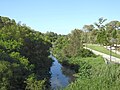 Kedron Brook stream, looking downstream from Gympie Road, Kedron (2021)
 -
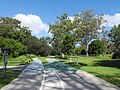 Bicycle and pedestrian paths, Kalinga Park, Kalinga (2021)
 -
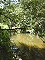 Kedron Brook looking upstream, Kalinga Park, Kalinga (2021)
 -
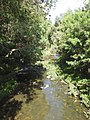 Kedron Brook looking downstream, Kalinga Park, Kalinga (2021)


See also
 Water portal
 Environment portal
 Queensland portal


References
- ^ a b c "Kedron Brook – watercourse in the City of Brisbane (entry 17849)". Queensland Place Names. Queensland Government. Retrieved 31 December 2022.
- ^ "Map of Upper Kedron, QLD". Bonzle Digital of Australia. Retrieved 24 September 2015.
- ^ a b c "Kedron Brook catchment" (PDF). Know your creek. City of Brisbane. 2012. Archived from the original (PDF) on 14 November 2022. Retrieved 24 September 2015.
- ^ "Physical Environment". Kedron Brook Catchment Network. Archived from the original on 23 June 2007.
- ^ Nally, Alicia; Feeney, Katherine (12 May 2022). "Under Brisbane lies coal, gold, quartz in small geological pockets". ABC News. Retrieved 21 January 2024.
- ^ "Kedron Brook". Councillor Kim Flesser, Northgate Ward. Archived from the original on 25 September 2015. Retrieved 31 December 2022.
- ^ Brisbane Airport Corporation Limited (December 2010). "New Parallel Runway Project Minor Variation to MDP (Approved 8 February 2011)" (PDF). City of Brisbane. Archived from the original (PDF) on 2 April 2016. Retrieved 24 September 2015.
- ^ "Kedron Brook restoration works". Brisbane City Council. Retrieved 31 December 2022.
- ^ a b Stone, Lucy (17 May 2022). "Flood-damaged Kedron Brook Bikeway repairs to take Brisbane City Council years". ABC News. Retrieved 21 January 2024.
External links
 Media related to Kedron Brook at Wikimedia Commons
- Kedron Brook Catchment Network
- "Location map for bushcare sites" (Map). Bushcare groups. Wildlife Preservation Society of Queensland Kedron Brook Catchment Branch (Inc.). 2015.
- "Kedron Brook trail". Cycling in Brisbane: Brisbane Bike Adventures. City of Brisbane. 7 April 2014.
- v
- t
- e
Waterways of the Brisbane Metropolitan catchment, Queensland, Australia
- Bramble Bay
- Deception Bay
- Moreton Bay
- Raby Bay
- Redland Bay
- Bremer
- Brisbane
Rivers of Queensland | |||||||||||||||
|---|---|---|---|---|---|---|---|---|---|---|---|---|---|---|---|
| |||||||||||||||
| |||||||||||||||
| |||||||||||||||
| |||||||||||||||
| |||||||||||||||
| |||||||||||||||


