Kozina
Place in Littoral, Slovenia
45°36′32.8″N 13°56′11.57″E / 45.609111°N 13.9365472°E / 45.609111; 13.9365472 Slovenia
 (2020)
Kozina (pronounced [kɔˈziːna] ⓘ; Italian: Cosina) is a settlement in the Municipality of Hrpelje-Kozina in the Littoral region of Slovenia, close to the border with Italy.[2]
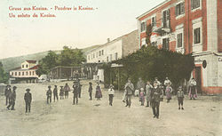
The village developed only after the railway was established; in 1825 there were only three houses in Kozina. It became an important center for teamsters, with twelve inns with stalls for teamsters' horses.[3] Today it lies at the intersection of the A1 motorway (Ljubljana–Koper) with Route 7 (Trieste–Rijeka).
References
External links
 Media related to Kozina at Wikimedia Commons
- Kozina on Geopedia
- v
- t
- e
Municipality of Hrpelje-Kozina
Administrative seat: Hrpelje
- Artviže
- Bač pri Materiji
- Beka
- Brezovica
- Brezovo Brdo
- Golac
- Gradišče pri Materiji
- Gradišica
- Hotična
- Javorje
- Klanec pri Kozini
- Kovčice
- Kozina
- Krvavi Potok
- Markovščina
- Materija
- Mihele
- Mrše
- Nasirec
- Obrov
- Ocizla
- Odolina
- Orehek pri Materiji
- Ostrovica
- Petrinje
- Poljane pri Podgradu
- Povžane
- Prešnica
- Ritomeče
- Rodik
- Rožice
- Skadanščina
- Slivje
- Slope
- Tatre
- Tublje pri Hrpeljah
- Velike Loče
- Vrhpolje

 | This article about the Municipality of Hrpelje-Kozina in Slovenia is a stub. You can help Wikipedia by expanding it. |
- v
- t
- e


