Lake Traverse Indian Reservation
Indian reservation in United States, Sisseton Wahpeton Oyate
Lake Traverse Indian Reservation | |
|---|---|
Indian reservation | |
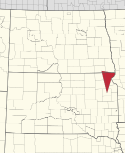 Location in North Dakota and South Dakota | |
| Tribe | Sisseton Wahpeton Oyate |
| Country | United States |
| States | North Dakota South Dakota |
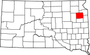
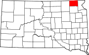
| Counties | Richland Sargent Codington Day Grant Marshall Roberts |
| Headquarters | Agency Village |
| Government | |
| • Body | Tribal Council |
| • Chairman | J. Garret Renville |
| • Vice-Chairman | Lexie Fancher-Lincoln |
| • Secretary | Curtis Bissonette |
| Population (2024)[1] | |
| • Total | 14,800 |
| Website | swo-nsn.gov |
The Lake Traverse Indian Reservation is the homeland of the federally recognized Sisseton Wahpeton Oyate, a branch of the Santee Dakota group of Native Americans. Most of the reservation covers parts of five counties in northeastern South Dakota, while smaller parts are in two counties in southeastern North Dakota, United States.
The Reservation was created by treaty on April 22, 1867 A.D. and called the Flatiron Reservation, in reference to its triangular shape.[2] It was created for the "friendly Dakota" from the Minnesota hostilities of 1862-1866. Signatories of the treaty were Gabriel Renville, John Otherday plus twenty-one other Sisseton and Wahpeton leaders.[2] Gabriel Renville was the first Chief of the Reservation.
Its resident population of 10,408 people, was counted during the 2000 census. About one-third of its inhabitants identify as of solely Native American heritage. Its largest community is the city of Sisseton, South Dakota. It operates a tribal college, Sisseton-Wahpeton Community College.
Geography
Over 60% of its land area lies in Roberts County, South Dakota, but there are lesser amounts in Marshall, Day, Grant and Codington counties in South Dakota, as well as Sargent and Richland counties in North Dakota.
Tribal information
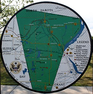
- Reservation: Former Lake Traverse; parts of Marshall, Day, Codington, Grant and Roberts counties
- Division: Santee
- Bands: Sisseton (Sinsin Tunwan: "Swamp Village"), Wahpeton (Wahpetowan: "Leaf Village")
- Land area: 106,153 acres/ 42,959 hectares (without boundaries)[vague]
- Tribal headquarters: Agency Village, SD
- Time zone: Central
- Traditional language: Dakota
- Enrolled members living within former reservation area: 9,894
- Major employers: Dakota Magic Casino, Dakota Sioux Casino, Dakota Western, Dakota Crossing Grocery, Dakota Connection Casino, tribal government, Bureau of Indian Affairs
Tribal government
- Charter: None; Constitution and Bylaws: Yes -IRA
- Date Approved: October 16, 1946
- Name of Governing Body: Sisseton-Wahpeton Sioux Tribal Council
- Number of council members: (7) seven council members
- Dates of Constitutional amendments: November 21, 1978, June 9, 1980
- Number of Executive Officers: (3) Tribal Chairman, Vice Chairman, and Tribal Secretary
Tribal elections
- Primary election is held in October and the general election in November. Members of council shall serve terms of four years. Any council and executive committee member shall serve no more than two consecutive terms for a total of eight years in the same office. Any council member or executive committee member may again file for office after a two-year time period.
- Number of election districts or communities: 10
Tribal Council meetings
- The council shall meet regularly on the first Tuesday, Wednesday and third Thursday of each month or upon call of the chairman of the council.
- Quorum number: General Council members is ten percent of eligible members
Education and media
- Tribal College: Sisseton-Wahpeton Community College, Agency Village
- Weekly newspaper: Sota Iya Ye Yapi ("smoke signals")
Notable people
- Paul War Cloud, (1930–1973), Sisseton-Wahpeton, was born in 1930 near Sica Hollow. A self-taught artist, War Cloud depicted Dakota culture and tradition in his paintings. Many of his works are on display at the Tekakwitha Fine Arts Center in Sisseton. A War Cloud mural, Unity Through the Great Spirit, hangs at the Cultural Heritage Center in Pierre, South Dakota.
- Gabriel Renville (1824–1892) was the last chief of the Sissetowan and Wahpetowan (non-hereditary). Born in Chief Sweet Corn's village on Lake Traverse, he was born into the Rainville/Renville clan, a Métis family of French and Dakota ancestry who had operated a trading post in Minnesota. His appointment by the federal government as chief in 1866 was seconded by the Sisseton-Wahpeton in 1867.
- Woodrow W. Keeble (1917–1982) was born in Waubay, but after the death of his mother, he was enrolled at Wahpeton Indian School in North Dakota. He became a soldier in the US Army and fought in WWII (Guadalcanal and other Pacific islands) and later in the Korean War. He was awarded the Distinguished Service Cross for his actions in Korea. He was posthumously awarded the Medal of Honor in 2008 for his actions in the Korean War.[3] He is buried on Lake Traverse Indian Reservation at Sisseton.
Communities
- Agency Village, South Dakota
- Claire City, South Dakota
- Goodwill, South Dakota
- Lake City, South Dakota (most, population 46)
- Long Hollow, South Dakota
- New Effington, South Dakota
- Ortley, South Dakota
- Peever, South Dakota
- Rosholt, South Dakota
- Sisseton, South Dakota
- Summit, South Dakota
- Veblen, South Dakota
- Waubay, South Dakota (part, population 15)
References
Wikimedia Commons has media related to Lake Traverse Indian Reservation.
- Lake Traverse Reservation, South Dakota/North Dakota United States Census Bureau
45°36′44″N 97°08′29″W / 45.61222°N 97.14139°W / 45.61222; -97.14139
- v
- t
- e

- Fort Berthold
- Lake Traverse
- Spirit Lake
- Standing Rock
- Turtle Mountain
| |
|---|---|
1 No reservation in the state, trust lands or legal status only |

| |||||||||||||||||||||||||||||||||||||||||||||||||||||||||||||||||||||||||||||||||||||||||||||||||||||||||||||||||||||||||||||||||||||||||||||||||||||||||||


Authority control databases | |
|---|---|
| International |
|
| National |
|
| Other |
|


