Lar Dam
Dam in Mazandaran, Amol county
35°53′21.58″N 51°59′45.54″E / 35.8893278°N 51.9959833°E / 35.8893278; 51.9959833Lavarak: 2012-2013
Lavarak: 2 x 23.5 MW Francis-type
Lavarak: 47 MW
https://thrw.ir/st/73
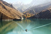
Lar Dam (Persian: سد لار sad-de lār) is a dam located at the foot of Mount Damavand in Amol county, Mazandaran, Iran. The dam is located within the protected Lar National Park, and situated just 70 kilometers northeast of the capital and the most populous city of the country, Iran. The primary purpose of the dam is municipal water supply to Tehran but prior to the water reaching the city filtration plant, it is used to power the Kalan and Lavarak Hydroelectric Power Stations, with a combined installed capacity of 162.5 MW.
Construction
Bridge
Lar Dam bridge | |
|---|---|
| Coordinates | 35°53′21″N 51°59′48″E / 35.8892°N 51.9967°E / 35.8892; 51.9967 |
| Characteristics | |
| Width | 13 m |
| Location | |
 | |
The construction began on the dam in 1974, and ended four years later in 1981. When the reservoir began in 1980, leakage was discovered downstream. The leakage is due to a karst foundation. The foundation was grouted from 1983 until 1989 with no success.[1] With the population growth occurring in Amol, there was a need for more water and energy. The ideal place for the dam was over the Lar river, in the northeast section of the city, at the elevated heights of the Kalanbasteh mountain on the slope of Mount Damavand. The area is called Polour, and operations began in 1984.
One of the aims for building the Lar dam was to supply part of Amol with drinking water; it was not possible initially to operate the dam at its nominal capacity, because of a water seepage problem. Water stored in the dam's reservoir is first transferred to the Kalan Power Station (35°48′24.87″N 51°47′29.46″E / 35.8069083°N 51.7915167°E / 35.8069083; 51.7915167 (Kalan Hydroelectric Power Station)) then to the Lavark Power Station (35°48′34.97″N 51°44′54.67″E / 35.8097139°N 51.7485194°E / 35.8097139; 51.7485194 (Lavarak Hydroelectric Power Station)), a distance of 3 kilometers from the Latyan Dam's reservoir, through the 20 kilometer long Kalan tunnel (3 meters in size). After electricity generation, the water joins and feeds the Latyan dam's reservoir. The Kalan Power Station was commissioned in 1998 and the Lavarak in March 2012 and July 2013.[2]
Uncontrolled growth and expansion of Tehran created a situation where the existing water resources at Karaj, Latyan and Lar dams and the deep wells which were supposed to be exploited only in the during the peak water consumption period. These were no longer capable of meeting the city's water demand, so inevitable abstraction from ground resources started to increase in a manner that at the present situation, the quantity of drilled deep wells has amounted to 230 rings. In fact, from 1997-2000, it had been orderly abstracted, 317, 289, 374 and 357 MCM (million cubic metres) of water from groundwater resources of the city.[3]
Lake

The lake is 84 km northeast of Tehran.
See also
Dams in Iran
References
- ^ Feghhi, Kh (2006). "Contribution of the Lar Dam-Polur Lineament in the Lar Dam Leakage". Dams and Reservoirs, Societies and Environment in the 21st Century. 1. London: Taylor & Francis Group: 699–706. ISBN 9780203963555. Retrieved 21 March 2013.
- ^ "News: Second Unit of Lavark Power Plant Joins the National Power Network". Iran Water and Power Resources Development Co. Retrieved 2 August 2013.
- ^ http://www.edu.joensuu.fi/eno/documents/global2.pdf#search=%22%22Lar%20Dam%22%22[permanent dead link]
External links
 Iran portal
 Water portal
 Renewable energy portal


Map all coordinates using OpenStreetMap
Download coordinates as:
- KML
- GPX (all coordinates)
- GPX (primary coordinates)
- GPX (secondary coordinates)
- Soil-water.com: Profile of Lar Dam
- FAO: Report on Lar Dam
- Ingenierie.fr: Lar Dam Project—(in French)
- v
- t
- e

- Alavian Dam
- Amir Kabir Dam
- Azad Dam
- Bust-e gez Dam
- Daryan Dam
- Dez Dam
- Doroodzan Dam
- Ashavan Dam
- Garan Dam
- Gavoshan Dam
- Giz Galasi Dam
- Cheragh Veys Dam
- Iran–Turkmenistan Friendship Dam
- Jiroft dam
- Shahid Abbaspour Dam
- Masjed Soleyman Dam
- Karun-3 Dam
- Karun-4 Dam
- Karkheh dam
- Khoda Afarin Dam
- Kouhrang 1 Dam
- Kouhrang 2 Dam
- Lar Dam
- Latyan Dam
- Mahabad Dam
- Mamloo Dam
- Marun Dam
- Rudbar Lorestan Dam
- Sardasht Dam
- Sefidrud Dam
- Seimare Dam
- Shahid Kazemi Dam
- Shahid Rajaee Dam
- Shahid Talebi Dam
- Shamo Dam
- Siah Bishe Pumped Storage Power Plant
- Silveh Dam
- Sivand Dam
- Sumbar Dam
- Tarik Dam
- Upper Gotvand Dam
- Zayanderud Dam
Also See: Dams and reservoirs in Iran


