Lira Airport
Airport

HULI
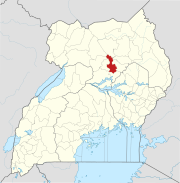
Location of the airport in Uganda
| Direction | Length | Surface | |
|---|---|---|---|
| m | ft | ||
| 10/28 | 940 | 3,084 | Murram |
Lira Airport (ICAO: HULI) is an airport serving Lira, a town in the Lira District of Uganda. Lira Airport is one of twelve upcountry airports that are administered by the Civil Aviation Authority of Uganda.[1][4] It is also one of the 46 airports in the country.[5]
Location
Lira Airport is in northern Uganda, approximately 250 kilometres (160 mi) by air, north of Entebbe International Airport, the country's largest civilian and military airport.[6]
See also
- Transport in Uganda
- List of airports in Uganda
- Lango sub-region
References
- ^ a b Lira Airfield, Uganda Civil Aviation Authority, 25 February 2014, accessed 15 November 2015
- ^ Google Maps - Lira
- ^ Airport information for HULI at Great Circle Mapper.
- ^ Uganda CAA Archived 2018-03-21 at the Wayback Machine dropdown list of airfields
- ^ "Uganda". CIA World Factbook.
Airports: 46 (2010)
- ^ "Distance between Entebbe and Lira with map". Distance Calculator. Globefeed.com. Retrieved 9 March 2010.
249.2 km (approximate travel/road distance 286.6 km to 311.6 km)
External links
- OpenStreetMap - Lira
- OurAirports - Lira
- Lira Airport
Portals:
 Uganda
 Aviation
 Africa


- v
- t
- e
 Lira District
Capital: Lira
sub-counties
Otuke County
villages
- Lira
- Barlonyo
- Boroboro
landmarks
- Lira Regional Referral Hospital
- Lira University Hospital


