List of historic places in northern and central British Columbia Interior
Map all coordinates using OpenStreetMap
Download coordinates as:
- KML
- GPX (all coordinates)
- GPX (primary coordinates)
- GPX (secondary coordinates)
The following list includes all of the Canadian Register of Historic Places listings in:
- Bulkley-Nechako Regional District,
- Cariboo Regional District,
- Fraser-Fort George Regional District,
- Peace River Country, and
- Stikine Country.
| Name | Address | Coordinates | Government recognition (CRHP №) | Image | |
|---|---|---|---|---|---|
| Barkerville | 53°3′57″N 121°31′2″W / 53.06583°N 121.51722°W / 53.06583; -121.51722 (Barkerville) | Federal (14309), British Columbia (1749) | Q808269 |  More images | |
| Fish Cache | Fort St. James BC | 54°26′06″N 124°15′22″W / 54.435°N 124.256°W / 54.435; -124.256 (Fish Cache) | Federal (2961) |  Upload Photo | |
| General Warehouse | Fort St. James BC | 54°26′06″N 124°15′22″W / 54.435°N 124.256°W / 54.435; -124.256 (General Warehouse) | Federal (2963) |  | |
| St. Andrew's Church | Bennett Lake BC | 59°46′09″N 135°07′05″W / 59.7692°N 135.118°W / 59.7692; -135.118 (St. Andrew's Church) | Federal (3653) |  More images | |
| Men's House | Fort St. James BC | 54°26′06″N 124°15′25″W / 54.435°N 124.257°W / 54.435; -124.257 (Men's House) | Federal (3665) | 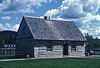 | |
| Officer's Dwelling | Fort St. James BC | 54°26′06″N 124°15′25″W / 54.435°N 124.257°W / 54.435; -124.257 (Officer's Dwelling) | Federal (3666) | Upload Photo | |
| Fort St. James National Historic Site of Canada | PO Box 1148 Fort St. James BC | 54°26′07″N 124°15′25″W / 54.4352°N 124.257°W / 54.4352; -124.257 (Fort St. James National Historic Site of Canada) | Federal (7617) | | |
| Chilkoot Trail National Historic Site of Canada | Cassiar BC | 59°46′02″N 135°06′36″W / 59.7673°N 135.11°W / 59.7673; -135.11 (Chilkoot Trail National Historic Site of Canada) | Federal (9087) |  More images | |
| Federal Building | 10401 10th Street, Dawson Creek Peace River Country BC | Federal (9522) | Upload Photo | ||
| Chee Kung Tong Building National Historic Site of Canada | Box 19 Barkerville BC | 53°04′00″N 121°31′01″W / 53.0667°N 121.517°W / 53.0667; -121.517 (Chee Kung Tong Building National Historic Site of Canada) | Federal (11971) |  | |
| Cottonwood House | 4660 Highway 26 Cottonwood BC | 53°03′02″N 122°09′25″W / 53.0505°N 122.157°W / 53.0505; -122.157 (Cottonwood House) | British Columbia (15813) |  | |
| Fort McLeod National Historic Site of Canada | Carp Lake Road, Fort McLeod Historic Park McLeod Lake BC | 54°59′00″N 123°03′00″W / 54.9833°N 123.05°W / 54.9833; -123.05 (Fort McLeod National Historic Site of Canada) | Federal (16523) | 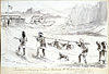 | |
| McLeod's Lake Post | Old Carp Lake Road McLeod Lake BC | 54°59′35″N 123°02′20″W / 54.993°N 123.039°W / 54.993; -123.039 (McLeod's Lake Post) | British Columbia (16592) |  | |
| Canadian National Railway Station | Main Street at Railway Avenue Smithers BC | 54°46′41″N 127°10′33″W / 54.778026°N 127.175833°W / 54.778026; -127.175833 (Canadian National Railway Station (Smithers)) | Federal (6493) |  | |
| Canadian National Railway Station | First Avenue and Main Street McBride BC | 53°18′04″N 120°10′12″W / 53.301003°N 120.169973°W / 53.301003; -120.169973 (Canadian National Railway Station (McBride)) | Federal (6631) |  | |
| Fort Alexandria National Historic Site of Canada | Alexandria BC | 52°33′47″N 122°28′48″W / 52.563°N 122.48°W / 52.563; -122.48 (Fort Alexandria National Historic Site of Canada) | Federal (17741) | 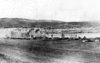 | |
| 108 Mile Heritage Site | Highway 97 108 Mile Ranch BC | 51°45′00″N 121°20′53″W / 51.7501°N 121.348°W / 51.7501; -121.348 (108 Mile Heritage Site) | 108 Mile Ranch municipality (18409) |  | |
| 150 Mile Little Red Schoolhouse | 3081 Old Schoolhouse Road 150 Mile House BC | 52°06′28″N 121°55′40″W / 52.1079°N 121.9277°W / 52.1079; -121.9277 (150 Mile Little Red Schoolhouse) | 150 Mile House municipality (18749) | Upload Photo | |
| 150 Mile Courthouse | Highway 97 150 Mile House BC | 52°06′35″N 121°55′42″W / 52.1097°N 121.9284°W / 52.1097; -121.9284 (150 Mile Courthouse) | 150 Mile House municipality (19032) | Upload Photo | |
| Knoll House | Chilanko Forks BC | Chilanko Forks municipality (19031) | Upload Photo | ||
| Telegraph Trail | Roughly, Highway 97 in the Cariboo Regional District Cariboo Regional District BC | 51°45′04″N 121°20′55″W / 51.7511°N 121.3487°W / 51.7511; -121.3487 (Telegraph Trail) | Cariboo Regional District municipality (20623) |  | |
| Blessing's Grave | Highway 26, 43 km east of Quesnel Pinegrove BC | 53°03′48″N 121°56′53″W / 53.0632°N 121.948°W / 53.0632; -121.948 (Blessing's Grave) | British Columbia (21414) | Upload Photo | |
| Potato House | 49 Borland Street Williams Lake BC | 52°07′47″N 122°08′46″W / 52.1296°N 122.1462°W / 52.1296; -122.1462 (Potato House) | British Columbia (20622) | Upload Photo |
References
- (references appear in the table above as external links)
- v
- t
- e
- CRHP
- Alberni-Clayoquot RD
- BC Coast
- Capital RD
- Kootenay RD
- Columbia-Shuswap RD
- Comox Valley RD
- Cowichan Valley RD
- East Kootenay RD
- Fraser Valley RD
- Kootenay Boundary RD
- Nanaimo RD
- New Westminster
- North Okanagan RD
- North Shore
- Northern/Central BC Interior
- Okanagan-Similkameen RD
- Squamish-Lillooet RD
- Strathcona RD
- Surrey
- Thompson-Nicola RD
- Vancouver
- Victoria
| |||||
| |||||||
| |||||
| |||||
Wildlife Management Areas | |
|---|---|
|
Other | |
|---|---|
|
 Category
- BC Parks
 Commons


