Manzanola Bridge
Demolished historical bridge
38°07′38″N 103°51′42″W / 38.12713°N 103.86156°W / 38.12713; -103.86156Manzanola Bridge
1950 (Second Manzanola Bridge - moved to new location)

Manzanola Bridge was a truss bridge which was originally built in 1911 by the Patterson-Burghardt Bridge Company over the Colorado River and later moved over the Arkansas River (on Colorado State Highway 207) in the year 1950.[2] The bridge used to connect the town of Manzanola, Otero County, with Crowley County in Colorado.
History
The first Manzanola Bridge was built in 1908, near Clifton in Mesa County over the Colorado River. It was replaced by a new design in 1950 and moved to a new location over the Arkansas River connecting Manzanola, Colorado with Crowley County, Colorado. At the new location, the new bridge replaced a "three-span pinned truss" which was built in 1908.[3][4]
On June 24, 1985, the bridge was added to the National Register of Historic Places.[5] In 1994, it was demolished and a more modern structure was constructed to handle the traffic of Colorado State Highway 207.
The 1950s structure was considered one of the earliest rigid-connected vehicular trusses in Colorado and one of seven riveted Pennsylvania through-truss bridges. At the time of its existence, it was recorded as the longest span roadway truss in the state.[3]
On July 7, 1994, the bridge's name was removed from the National Register of Historic Places.[6]
Gallery
This gallery consists of the photographs taken for the Historic American Engineering Record, dated August 18, 1983.[3]
-
 View: Looking east, showing west web
 -
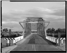 View: Looking south, showing portal
 -
 View: Looking southeast, showing bottom chord, floor structure, and west web detail
 -
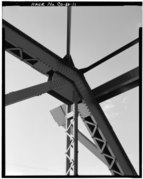 View: Looking southeast, showing upper chord and portal bracing detail
 -
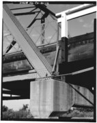 View: Looking southwest, showing pier and roller bearing shoe detail
 -
 View: Looking southwest, showing vertical, diagonal, and guardrail detail
 -
 View: Looking south, showing deck, vertical, upper strut and bracing detail
 -
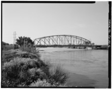
 Overall view of Manzanola Bridge, State Highway 202 and Arkansas River, looking southwest


See also
References
- ^ "National Register Information System". National Register of Historic Places. National Park Service. November 2, 2013.
- ^ "Manzanola Bridge". Bridgehunter.com. Retrieved 2020-09-20.
- ^ a b c Yearby, Jean P.; Fraser, Clayton; Hallberg, Carl (1985). "Manzanola Bridge (Clifton Bridge)" (PDF). Historic American Engineering Record. Washington, D.C.: Library of Congress. Retrieved December 28, 2021.
- ^ "National Register of Historic Places Inventory/Nomination: Manzanola Bridge". National Park Service. Retrieved September 22, 2020. With accompanying photos
- ^ "List of properties have been entered in the National Register of Historic Places beginning June 23, 1985, and ending June 29, 1985" (PDF). Wikimedia Commons. Washington, D.C. 20240: United States Department of the Interior, National Park Service. June 29, 1985. p. 1. Retrieved September 20, 2020.
{{cite web}}: CS1 maint: location (link) - ^ Manzanola Bridge at archINFORM. Retrieved 20 September 2020.
External links
- Historic American Engineering Record (HAER) No. CO-20, "Manzanola Bridge, State Highway 207, spanning Arkansas River, Manzanola, Otero County, CO", 12 photos, 3 data pages, 1 photo caption page
- v
- t
- e
- List of U.S. National Historic Landmarks by state:
- Alabama
- Alaska
- Arizona
- Arkansas
- California
- Colorado
- Connecticut
- Delaware
- Florida
- Georgia
- Hawaii
- Idaho
- Illinois
- Indiana
- Iowa
- Kansas
- Kentucky
- Louisiana
- Maine
- Maryland
- Massachusetts
- Michigan
- Minnesota
- Mississippi
- Missouri
- Montana
- Nebraska
- Nevada
- New Hampshire
- New Jersey
- New Mexico
- New York
- North Carolina
- North Dakota
- Ohio
- Oklahoma
- Oregon
- Pennsylvania
- Rhode Island
- South Carolina
- South Dakota
- Tennessee
- Texas
- Utah
- Vermont
- Virginia
- Washington
- West Virginia
- Wisconsin
- Wyoming
 National Register of Historic Places portal
 Category


