Moodna Viaduct
Bridge in United States of America
41°25′49″N 74°05′57″W / 41.43028°N 74.09917°W / 41.43028; -74.09917(owned by Norfolk Southern)

The Moodna Viaduct is a steel[1] railroad trestle spanning Moodna Creek and its valley at the north end of Schunemunk Mountain in Cornwall, New York, near the hamlet of Salisbury Mills.
Significance
The bridge was constructed between 1906 and 1909 by the Erie Railroad as part of its Graham Line freight bypass, and was opened for service in January 1909. The trestle spans the valley for 3,200 feet (975 m) and is 193 feet (59 m) high at its highest point, making it the second-highest and -longest railroad trestle east of the Mississippi River (after the 1889 Poughkeepsie Bridge of the New York, New Haven and Hartford Railroad, which is 6,768 ft (2,063 m) long and 212 ft (65 m) high). Apart from the valley below, the viaduct crosses two roads (Otterkill Rd. and Orrs Mills Rd.), the Moodna Creek, and the Erie Railroad's now-abandoned Newburgh Branch. The open design of the trestle was used to reduce wind resistance and is a major reason why the trestle is still in service today.[2]
Current use
The viaduct carries New Jersey Transit/Metro-North Port Jervis commuter line trains and Norfolk Southern freight trains. The Metro-North Salisbury Mills–Cornwall station sits near the north end of the viaduct. In summer 2007, timber replacement on the viaduct caused delays on the line due to slow orders placed on it, and required that service be halted during weekend days.[3] Repairs were made to several of the concrete piers in October 2009, but traffic remained uninterrupted.
It is also a tourist attraction for the small town of Salisbury Mills. Two major roads cross under it, the major one is Orange County Route 94. The viaduct creates a spectacular landscape when viewed from the corner of Orrs Mills Road and Jackson Avenue outside of town, frequently photographed during fall foliage season.
The Moodna Viaduct appears as a prominent feature in the 2007 film Michael Clayton[4] and in the 2020 film The Half of It.[5]

Gallery
-
 View point across the length of the Moodna Viaduct from one of the ends.
 -
 View from Moodna Viaduct looking east.
 -
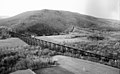 View of the Moodna Viaduct in 1971.


See also
- List of bridges documented by the Historic American Engineering Record in New York (state)
- List of Erie Railroad structures documented by the Historic American Engineering Record
References
- ^ Patrick, Clifton (November 8, 2009). "Moodna Viaduct Historical Marker". www.hmdb.org. The Historical Marker Database. Retrieved March 12, 2023.
- ^ "Port Jervis line – Page 3 – I Ride The Harlem Line…". www.iridetheharlemline.com. 10 April 2012. Retrieved 2016-01-24.
- ^ Rife, Judy (July 24, 2007). "Moodna Viaduct repairs scheduled for this weekend". Times Herald-Record. Middletown. Archived from the original on 2018-07-29. Retrieved 2007-08-06.
- ^ "Trivia for Michael Clayton (IMDB)". IMDb. Retrieved 2008-07-09.
- ^ "The Squahamish Town Filming Location: Where was The Half of It filmed?". Atlas of Wonders. Retrieved 2020-11-19.
External links
Wikimedia Commons has media related to Moodna Viaduct.
- Historic American Engineering Record (HAER) No. NY-62, "Erie Railway, Moodna Creek Viaduct"
- NJT MNRR Moodna Viaduct on YouTube. Video taken from a train crossing the viaduct.
- Happy 100th Birthday Moodna Viaduct on YouTube. Video taken August 2007 showing the span.
- Moodna Viaduct Filmed with a UAV on YouTube. Drone footage of the Moodna Viaduct.


