Mount Blackburn
Volcano


Mount Blackburn
Location in Alaska
Mount Blackburn (Ahtna: K’ats’i Tl’aadi) is the highest peak in the Wrangell Mountains of Alaska in the United States. It is the fifth-highest peak[a] in the United States and the twelfth-highest peak in North America. The mountain is an old, eroded shield volcano, the second-highest volcano in the U.S. behind Mount Bona and the fifth-highest in North America. It was named in 1885 by Lt. Henry T. Allen of the U.S. Army after Joseph Clay Stiles Blackburn, a U.S. senator from Kentucky.[2] It is located in the heart of Wrangell – St. Elias National Park, the largest national park in the country.
Description
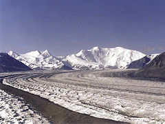
The mountain's massif is covered almost entirely by icefields and glaciers and is the principal source of ice for the Kennicott Glacier, which flows southeast over 20 miles (32 km) to just above the town of McCarthy. The mountain also contributes a large volume of ice to the north-flowing Nabesna Glacier and the Kuskulana Glacier system.
Mount Blackburn is a large, dramatic peak, with great local relief and independence from higher peaks. Its west face drops over 11,000 ft (3,350 m) to the Kuskulana Glacier in less than 4 horizontal miles (6.4 km). Its other faces drop 8,000–10,000 ft (2,440–3,050 m), all in less than 8 miles (13 km). The toe of the Kuskulana Glacier, less than 12 miles (19 km) from the summit, lies at an elevation of 2,400 ft (730 m), giving a rise of 14,000 ft (4,270 m). While these figures speak to the peak's relief, one measure of its independence is that it is the 50th-most topographically prominent peak in the world.[3]
The western of Blackburn's two summits is the mountain's highest point, a fact that was not understood until the 1960s when new USGS maps were published. The first ascent of the west peak, and hence Mount Blackburn, was done on May 30, 1958, by Bruce Gilbert, Dick Wahlstrom, Hans Gmoser, Adolf Bitterlich, and Leon Blumer via the North (also called the Northwest) Ridge. This team made the first ascent of Blackburn but did not even know it at the time due to the incorrect identification of the highest point. Blumer's article in the 1959 American Alpine Journal is titled "Mount Blackburn – Second Ascent."
Other subfeatures

Kennedy Peak, or East Blackburn, 16,286 ft (4,964 m), is the eastern summit and was originally thought to be the highest point. The first ascent of this summit was made in 1912 by Dora Keen and George Handy via the Kennicott Glacier (on the south side of the mountain) and East Face. This heady exploit was ahead of its time. Dora Keen, driven by a deep desire for the climb, solicited miners from the nearby Kennecott Copper Mines, and forged a route up the heavily crevassed East Face to the East Peak, but did not traverse over to the West Peak. Keen went on to write a famous article for the Saturday Evening Post titled, "First up Mount Blackburn." In 1912, Keen and Handy thought they were on Blackburn's highest point.
Geology
Mount Blackburn represents the heavily eroded core of a shield volcano. Because it is shrouded in permanent ice, its internal structure cannot be determined. It is believed to have a summit caldera, greatly modified by glaciation. The oldest rocks in the area are granites, about 4.2 million years old, representing an intrusive mass. The majority of the mountain is 3.4 million year old granite, intruding between andesite flows. From this it is inferred that a caldera collapse took place between 4.2 and 3.4 million years ago, after which activity ceased.[4]
Climbing
Today's standard route on the peak is the 1958 ascent route, the North (or Northwest) Ridge, which is approached from the Nabesna Glacier, on the north side of the mountain, opposite from Keen and Hardy's route. The route starts from an airstrip on the glacier at an altitude of 7,200 feet (2,200 m). It is a moderate climb by Alaskan standards (Alaska Grade 2).
See also
 North America portal
 United States portal
 Alaska portal
 Mountains portal
 Volcanoes portal


- List of mountain peaks of North America
- List of the highest major summits of the United States
- List of the most prominent summits of the United States
- List of the most isolated major summits of the United States
- List of volcanoes in the United States
References and notes
Notes
References
- ^ a b c "Mount Blackburn, Alaska". Peakbagger.com. Retrieved December 30, 2015.
- ^ "USGS GNIS: Mount Blackburn". Retrieved March 8, 2007.
- ^ "Peaklist.org: 50 Most Prominent Peaks on Earth". peaklist.org. Retrieved March 9, 2007.
- ^ Richter, Donald H.; Rosenkrans, Danny S.; Steigerwald, Margaret J. "Guide to the Volcanoes of the Western Wrangll Mountains, Alaska, U.S. Geological Survey Bulletin 2072" (PDF). U.S. Geological Survey.
Sources
- Wood, Michael; Coombs, Colby (2001). Alaska: A Climbing Guide. Mountaineers Books. ISBN 0-89886-724-X.
- Richter, Donald H.; Rosenkrans, Danny S.; Steigerwald, Margaret J. (1995). Guide to the Volcanoes of the Western Wrangell Mountains, Alaska (PDF). USGS Bulletin 2072.
- Winkler, Gary R. (2000). A Geologic Guide to Wrangell—Saint Elias National Park and Preserve, Alaska: A Tectonic Collage of Northbound Terranes. USGS Professional Paper 1616. ISBN 0-607-92676-7.
- Richter, Donald H.; Preller, Cindi C.; Labay, Keith A.; Shew, Nora B. (2006). Geologic Map of the Wrangell-Saint Elias National Park and Preserve, Alaska. USGS Scientific Investigations Map 2877.
External links
Mount Blackburn at Wikipedia's sister projects
 Definitions from Wiktionary
 Media from Commons
 News from Wikinews
 Quotations from Wikiquote
 Texts from Wikisource
 Textbooks from Wikibooks
 Resources from Wikiversity
- v
- t
- e
- Denali
- Mount Logan
- Pico de Orizaba
- Mount Saint Elias
- Volcán Popocatépetl
- Mount Foraker
- Mount Lucania
- Volcán Iztaccíhuatl
- King Peak
- Mount Bona
- Mount Steele
- Mount Blackburn
- Mount Sanford
- Mount Wood
- Mount Vancouver
- Mount Slaggard
- Nevado de Toluca
- Mount Fairweather
- Sierra Negra
- Mount Hubbard
- Mount Bear
- Mount Walsh
- Mount Hunter
- Volcán La Malinche
- Mount Whitney
- Mount Alverstone
- University Peak
- Mount Elbert
- Mount Massive
- Mount Harvard
- Mount Rainier
- Mount Williamson
- McArthur Peak
- Blanca Peak
- La Plata Peak
- Uncompahgre Peak
- Crestone Peak
- Mount Lincoln
- Castle Peak
- Grays Peak
- Mount Antero
- Mount Blue Sky
- Longs Peak
- Mount Wilson
- White Mountain Peak
- North Palisade
- Mount Princeton
- Mount Yale
- Mount Shasta
- Maroon Peak
- Mount Wrangell
- Mount Sneffels
- Capitol Peak
- Pikes Peak
- Windom Peak/Mount Eolus
- Mount Augusta
- Handies Peak
- Culebra Peak
- Cofre de Perote
- San Luis Peak
- Mount of the Holy Cross
- Nevado de Colima
- Grizzly Peak
- Mount Humphreys
- Mount Keith
- Mount Strickland
- Mount Ouray
- Vermilion Peak
- Avalanche Peak
- Atna Peaks
- Volcán Tajumulco
- Regal Mountain
- Mount Darwin
- Mount Hayes
- Mount Silverheels
- Rio Grande Pyramid
- Gannett Peak
- Mount Kaweah
- Grand Teton
- Mount Cook
- Mount Morgan
- Mount Gabb
- Bald Mountain
- Mount Oso
- Mount Jackson
- Mount Tom
- Bard Peak
- Cerro Tláloc
- West Spanish Peak
- Mount Powell
- Hagues Peak
- Mount Dubois
- Tower Mountain
- Treasure Mountain
- Kings Peak
- North Arapaho Peak
- Mount Pinchot
- Mount Natazhat
- Mount Jarvis
- Parry Peak
- Bill Williams Peak
- Sultan Mountain
- Mount Herard
- Volcán Tacaná
- West Buffalo Peak
- Mount Craig
- Tressider Peak
- Summit Peak
- Middle Peak/Dolores Peak
- Antora Peak
- Henry Mountain
- Hesperus Mountain
- Mount Silverthrone
- Jacque Peak
- Bennett Peak
- Wind River Peak
- Mount Waddington
- Conejos Peak
- Mount Marcus Baker
- Cloud Peak
- Wheeler Peak
- Francs Peak
- Twilight Peak
- South River Peak
- Mount Ritter
- Red Slate Mountain

Authority control databases | |
|---|---|
| International |
|
| National |
|


