Mount Sarrail
Mountain in the country of Canada


Mount Sarrail
Location of Mount Sarrail in Alberta
Show map of Alberta
Mount Sarrail
Mount Sarrail (Canada)
Show map of CanadaCanadian Rockies
Mount Sarrail is a 3,159-metre (10,364-foot) mountain summit located in Kananaskis Country in the Canadian Rockies of Alberta, Canada. Mount Sarrail is situated 1.0 kilometre north of the Continental Divide, within Peter Lougheed Provincial Park. Its nearest higher peak is Mount Foch, 1.0 km (0.62 mi) to the southeast.[3] Mount Sarrail can be seen from Upper Kananaskis Lake and Alberta Highway 40.
History
The mountain was named in 1918 for General Maurice Sarrail (1856-1929), the commander of the French Third Army in World War I.[3][6][1]
The mountain's name was officially adopted in 1924 by the Geographical Names Board of Canada.[4]
The first ascent of the mountain was made in 1930 by Kate (Katie) Gardiner and Walter Feuz.[3] The duo also made the first ascents of nearby Mount Foch and Mount Lyautey that same year.[7]
Geology
Mount Sarrail is composed of sedimentary rock laid down during the Precambrian to Jurassic periods. Formed in shallow seas, this sedimentary rock was pushed east and over the top of younger rock during the Laramide orogeny.[8]
Climate
Based on the Köppen climate classification, Mount Sarrail is located in a subarctic climate with cold, snowy winters, and mild summers.[9] Temperatures can drop below −20 °C with wind chill factors below −30 °C. In terms of favorable weather, June through September are the best months to climb Mount Sarrail. Precipitation runoff from the mountain drains into tributaries of the Kananaskis River.
See also
References
- ^ a b "Mount Sarrail". cdnrockiesdatabases.ca. Retrieved 2021-11-07.
- ^ "Topographic map of Mount Sarrail". opentopomap.org. Retrieved 2021-11-07.
- ^ a b c d e f "Mount Sarrail". Bivouac.com. Retrieved 2018-11-08.
- ^ a b c "Mount Sarrail". Geographical Names Data Base. Natural Resources Canada. Retrieved 2018-12-14.
- ^ Kane, Alan (2016). "Mount Sarrail". Scrambles in the Canadian Rockies (3rd ed.). Calgary: Rocky Mountain Books. Kindle Edition. ISBN 978-1-77160-098-9.
- ^ Place-names of Alberta. Ottawa: Geographic Board of Canada. 1928. p. 113.
- ^ "Mount Foch". cdnrockiesdatabases.ca. Retrieved 2021-11-07.
- ^ Gadd, Ben (2008), Geology of the Rocky Mountains and Columbias
- ^ Peel, M. C.; Finlayson, B. L.; McMahon, T. A. (2007). "Updated world map of the Köppen−Geiger climate classification". Hydrol. Earth Syst. Sci. 11: 1633–1644. ISSN 1027-5606.
Gallery
-
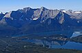
 Upper Kananaski Lake with Mount Sarrail to right
 -
 Aerial view of Foch and Sarrail with the Kananaskis Lakes
 -
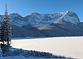 Mount Sarrail in winter
 -
 Mount Sarrail
 -
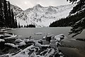 Mount Sarrail seen from Rawson Lake


External links
- Mount Sarrail weather: Mountain Forecast
- Scrambling Mount Sarrail: Explor8ion.com
Places adjacent to Mount Sarrail | ||||||||||||||||
|---|---|---|---|---|---|---|---|---|---|---|---|---|---|---|---|---|
| ||||||||||||||||


- v
- t
- e
- Ball
- Bare
- Beaverfoot
- Blue
- Bow
- Crowsnest
- Elk
- Fairholme
- Fiddle
- Flathead
- Foothills
- High Rock
- Kananaskis
- Livingstone
- Lizard
- Maligne
- Massive
- Misty
- Morrissey
- Palliser
- President
- Queen Elizabeth
- Rainbow
- Ram
- Sawback
- Sentinel
- Slate
- South Jasper
- Sundance
- Terminal
- Tower of London
- Vermilion
- Victoria Cross
- Waputik
- Winston Churchill
- Continental Ranges
- Hart Ranges
- Muskwa Ranges
- Alberta
- Andromeda
- Assiniboine
- Athabasca
- Brazeau
- Bryce
- Cascade
- Castle
- Castleguard
- Clemenceau
- Columbia
- Cory
- Edith Cavell
- Forbes
- Hector
- Hosmer
- Hungabee
- Joffre
- Kitchener
- Lyell
- Heart
- Pilot
- Pyramid
- Resplendent
- Robson
- Rundle
- Sarbach
- Saskatchewan
- Smythe
- Snow Dome
- Stanley Peak
- Sulphur
- Temple
- Three Sisters
- Trinity
- Twin
- Ulysses
- Unnamed Alberta–BC mountain (formerly Mount Pétain)
- Whymper
see List of rivers of the Canadian Rockies and Category:Rivers of the Canadian Rockies
- Mountain Stoney
- Mountain Metis
| International | |
|---|---|
| National |
|
| Provincial (AB) |
|
| Provincial (BC) |
- See also
- Geography portal
- Canada portal


