National Register of Historic Places listings in Meade County, South Dakota

This is a list of the National Register of Historic Places listings in Meade County, South Dakota.
This is intended to be a complete list of the properties and districts on the National Register of Historic Places in Meade County, South Dakota, United States. The locations of National Register properties and districts for which the latitude and longitude coordinates are included below, may be seen in a map.[1]
There are 32 properties and districts listed on the National Register in the county, including 1 National Historic Landmark.
This National Park Service list is complete through NPS recent listings posted June 14, 2024.[2]
Map all coordinates using OpenStreetMap
Download coordinates as:
- KML
- GPX (all coordinates)
- GPX (primary coordinates)
- GPX (secondary coordinates)
Current listings
| [3] | Name on the Register[4] | Image | Date listed[5] | Location | City or town | Description |
|---|---|---|---|---|---|---|
| 1 | Archeological Site No. 39MD20 | Upload image | August 6, 1993 (#93000798) | Address restricted[6] | Tilford | |
| 2 | Archeological Site No. 39MD81 | Upload image | April 14, 1994 (#93000818) | Address restricted[6] | Sturgis | |
| 3 | Archeological Site No. 39MD82 | Upload image | April 14, 1994 (#93000797) | Address restricted[6] | Sturgis | |
| 4 | Joseph Baker House | Upload image | April 30, 1986 (#86000942) | County Road 19A Coordinates missing | Hereford | |
| 5 | L.L. Bartlett House | Upload image | April 30, 1986 (#86000946) | County Road 26 Coordinates missing | Stoneville | |
| 6 | Bear Butte |  | June 19, 1973 (#73001746) | Northeast of Sturgis 44°28′25″N 103°25′33″W / 44.473611°N 103.425833°W / 44.473611; -103.425833 (Bear Butte) | Sturgis | |
| 7 | Bethel Lutheran Church | Upload image | April 30, 1986 (#86000941) | Main and 5th Sts. 45°01′10″N 102°02′19″W / 45.019444°N 102.038611°W / 45.019444; -102.038611 (Bethel Lutheran Church) | Faith | |
| 8 | Black Hawk Elementary School | Upload image | April 30, 1986 (#86000939) | Main and Elm Sts. 44°09′04″N 103°18′35″W / 44.151111°N 103.309722°W / 44.151111; -103.309722 (Black Hawk Elementary School) | Blackhawk | |
| 9 | Black Hills National Cemetery | 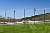 | May 17, 2016 (#16000258) | 20901 Pleasant Valley Dr. 44°22′11″N 103°28′28″W / 44.369811°N 103.474324°W / 44.369811; -103.474324 (Black Hills National Cemetery) | Sturgis | |
| 10 | Covered Wagon Resort | Upload image | November 20, 2007 (#07001213) | 14189 County Road 79 44°13′01″N 103°22′23″W / 44.216871°N 103.373110°W / 44.216871; -103.373110 (Covered Wagon Resort) | Piedmont | |
| 11 | Erskine School | 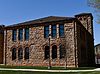 | August 16, 1984 (#84003354) | Sherman St. 44°24′45″N 103°30′52″W / 44.4125°N 103.514444°W / 44.4125; -103.514444 (Erskine School) | Sturgis | |
| 12 | John and Coralin Evans Ranch | Upload image | April 30, 1986 (#86000943) | County Road 4 Coordinates missing | Piedmont | |
| 13 | Fort Meade National Historic District |  | May 22, 1973 (#73001747) | East of Sturgis on Highway 34 44°24′46″N 103°28′22″W / 44.412778°N 103.472778°W / 44.412778; -103.472778 (Fort Meade National Historic District) | Sturgis | |
| 14 | Fort Meade Veterans Administration Hospital | Upload image | May 29, 2018 (#100002467) | 113 Comanche Rd. 44°24′44″N 103°28′11″W / 44.4121°N 103.4697°W / 44.4121; -103.4697 (Fort Meade Veterans Administration Hospital) | Fort Meade | |
| 15 | Frozenman Stage Station | Upload image | June 18, 1992 (#92000691) | Address restricted[6] | Bison | |
| 16 | Stephen and Maria Graf House | 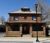 | October 31, 2002 (#02001283) | 1233 Main St. 44°24′52″N 103°30′49″W / 44.414444°N 103.513611°W / 44.414444; -103.513611 (Stephen and Maria Graf House) | Sturgis | |
| 17 | H O Ranch Log House | Upload image | June 21, 1990 (#90000954) | 3 miles west of Marcus 44°39′49″N 102°20′10″W / 44.663611°N 102.336111°W / 44.663611; -102.336111 (H O Ranch Log House) | Marcus | |
| 18 | Ole and Carris Johnson Ranch | Upload image | April 30, 1986 (#86000938) | County Road 7 Coordinates missing | Blackhawk | |
| 19 | John and Elsie McMillan House | 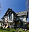 | October 30, 2015 (#15000765) | 1611 Davenport St. 44°24′30″N 103°30′29″W / 44.408404°N 103.508065°W / 44.408404; -103.508065 (John and Elsie McMillan House) | Sturgis | |
| 20 | Minneapolis Brewing Company Beer Warehouse | Upload image | February 9, 2001 (#01000100) | Highway 212 45°01′24″N 102°02′07″W / 45.023333°N 102.035278°W / 45.023333; -102.035278 (Minneapolis Brewing Company Beer Warehouse) | Faith | |
| 21 | Municipal Building-City Hall | Upload image | June 22, 2000 (#00000722) | 206 Main St. 45°01′20″N 102°02′18″W / 45.0221893°N 102.0383824°W / 45.0221893; -102.0383824 (Municipal Building-City Hall) | Faith | Architect U.L. Freed. Now the Municipal Bar/Liquor Store. |
| 22 | Elias B. Olsen Ranch | Upload image | April 30, 1986 (#86000940) | County Road 6 Coordinates missing | Elm Springs | |
| 23 | Jacob and Elizabeth Raskob Ranch | Upload image | April 30, 1986 (#86000945) | Highway 34 44°28′12″N 103°20′54″W / 44.47°N 103.348333°W / 44.47; -103.348333 (Jacob and Elizabeth Raskob Ranch) | Sturgis | |
| 24 | Royal Center School | Upload image | February 21, 2023 (#100008632) | Northwest corner of intersection of Sulphur Cutoff and Stoneville Rds. 44°54′27″N 102°39′17″W / 44.9074°N 102.6548°W / 44.9074; -102.6548 (Royal Center School) | Opal vicinity | |
| 25 | South Dakota Dept. of Transportation Bridge No. 47-151-389 | Upload image | December 9, 1993 (#93001263) | Local road over Bear Butte Creek 44°28′33″N 103°15′58″W / 44.4758085°N 103.2661736°W / 44.4758085; -103.2661736 (South Dakota Dept. of Transportation Bridge No. 47-151-389) | Sturgis | Replaced in 2010[7] |
| 26 | Stevens Ranch | Upload image | April 30, 1986 (#86000944) | County Road 4 Coordinates missing | Piedmont | |
| 27 | Stomprude Trail Ruts | Upload image | June 18, 1992 (#92000690) | Address restricted[6] | Bison | |
| 28 | Sturgis Commercial Block | 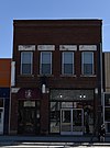 | June 20, 1975 (#75001719) | 1000-1028 Main St. 44°24′50″N 103°30′33″W / 44.413889°N 103.509167°W / 44.413889; -103.509167 (Sturgis Commercial Block) | Sturgis | |
| 29 | Sturgis High School |  | August 16, 2000 (#00000998) | 1425 Cedar St. 44°24′35″N 103°31′16″W / 44.409722°N 103.521111°W / 44.409722; -103.521111 (Sturgis High School) | Sturgis | |
| 30 | Sturgis Water Works Company Supply Works Site | Upload image | December 6, 2016 (#16000827) | 2835 Davenport St. 44°21′41″N 103°30′58″W / 44.361527°N 103.516183°W / 44.361527; -103.516183 (Sturgis Water Works Company Supply Works Site) | Sturgis | |
| 31 | Annie Tallent House | 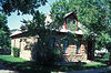 | May 28, 1976 (#76001746) | 1603 Main St. 44°24′53″N 103°31′01″W / 44.414722°N 103.516944°W / 44.414722; -103.516944 (Annie Tallent House) | Sturgis | |
| 32 | John G. Wenke House |  | May 28, 1976 (#76001747) | 1340 Junction Ave. 44°24′39″N 103°30′30″W / 44.410833°N 103.508333°W / 44.410833; -103.508333 (John G. Wenke House) | Sturgis |
Former listings
| [3] | Name on the Register | Image | Date listed | Date removed | Location | City or town | Description |
|---|---|---|---|---|---|---|---|
| 1 | South Dakota Dept. of Transportation Bridge No. 47-215-363 | Upload image | December 9, 1993 (#93001303) | December 15, 1999 | SD 34 over the Belle Fourche R. | Sturgis vicinity | |
| 2 | Poker Alice Tubbs House | Upload image | June 5, 1975 (#75001720) | May 29, 1990 | N. Junction St.(Original location: Now located at:) 44°24′23″N 103°30′31″W / 44.4064422°N 103.508569°W / 44.4064422; -103.508569 (Poker Alice Tubbs House) | Sturgis | Delisted in 1990 after being relocated to Sturgis.[8] |
See also
Wikimedia Commons has media related to National Register of Historic Places in Meade County, South Dakota.
- List of National Historic Landmarks in South Dakota
- National Register of Historic Places listings in South Dakota
References
- ^ The latitude and longitude information provided in this table was derived originally from the National Register Information System, which has been found to be fairly accurate for about 99% of listings. Some locations in this table may have been corrected to current GPS standards.
- ^ National Park Service, United States Department of the Interior, "National Register of Historic Places: Weekly List Actions", retrieved June 14, 2024.
- ^ a b Numbers represent an alphabetical ordering by significant words. Various colorings, defined here, differentiate National Historic Landmarks and historic districts from other NRHP buildings, structures, sites or objects.
- ^ "National Register Information System". National Register of Historic Places. National Park Service. April 24, 2008.
- ^ The eight-digit number below each date is the number assigned to each location in the National Register Information System database, which can be viewed by clicking the number.
- ^ a b c d e Federal and state laws and practices restrict general public access to information regarding the specific location of this resource. In some cases, this is to protect archeological sites from vandalism, while in other cases it is restricted at the request of the owner. See: Knoerl, John; Miller, Diane; Shrimpton, Rebecca H. (1990), Guidelines for Restricting Information about Historic and Prehistoric Resources, National Register Bulletin, National Park Service, U.S. Department of the Interior, OCLC 20706997.
- ^ https://uglybridges.com/1493439 [dead link]
- ^ "Movers move Poker Alice's 'bawdiest of bawdy' house". Rapid City Journal. March 29, 1990. p. B5. Retrieved August 27, 2022 – via Newspapers.com.
- v
- t
- e

county
- Aurora
- Beadle
- Bennett
- Bon Homme
- Brookings
- Brown
- Brule
- Buffalo
- Butte
- Campbell
- Charles Mix
- Clark
- Clay
- Codington
- Corson
- Custer
- Davison
- Day
- Deuel
- Dewey
- Douglas
- Edmunds
- Fall River
- Faulk
- Grant
- Gregory
- Haakon
- Hamlin
- Hand
- Hanson
- Harding
- Hughes
- Hutchinson
- Hyde
- Jackson
- Jerauld
- Jones
- Kingsbury
- Lake
- Lawrence
- Lincoln
- Lyman
- Marshall
- McCook
- McPherson
- Meade
- Mellette
- Miner
- Minnehaha
- Moody
- Oglala Lakota
- Pennington
- Perkins
- Potter
- Roberts
- Sanborn
- Spink
- Stanley
- Sully
- Todd
- Tripp
- Turner
- Union
- Walworth
- Yankton
- Ziebach
 Category
 List
List National Register of Historic Places Portal


Municipalities and communities of Meade County, South Dakota, United States | ||
|---|---|---|
County seat: Sturgis | ||
| Cities |  | |
| CDPs | ||
| Former CDP | ||
| Other communities | ||
| Indian reservations | ||
| Ghost towns | ||
| Footnotes | ‡This populated place also has portions in an adjacent county or counties | |
| ||


