National Register of Historic Places listings in Spotsylvania County, Virginia

This is a list of the National Register of Historic Places listings in Spotsylvania County, Virginia.
This is intended to be a complete list of the properties and districts on the National Register of Historic Places in Spotsylvania County, Virginia, United States. The locations of National Register properties and districts for which the latitude and longitude coordinates are included below, may be seen in an online map.[1]
There are 17 properties and districts listed on the National Register in the county.
This National Park Service list is complete through NPS recent listings posted June 14, 2024.[2]
Map all coordinates using OpenStreetMap
Download coordinates as:
- KML
- GPX (all coordinates)
- GPX (primary coordinates)
- GPX (secondary coordinates)
Current listings
| [3] | Name on the Register[4] | Image | Date listed[5] | Location | City or town | Description |
|---|---|---|---|---|---|---|
| 1 | Andrews Tavern |  | July 30, 1976 (#76002121) | 2.6 miles (4.2 km) northeast of Glenora on Lawyers Rd. 38°07′19″N 77°46′09″W / 38.121944°N 77.769167°W / 38.121944; -77.769167 (Andrews Tavern) | Glenora | Federal provincial home constructed for Samuel Andrews in 1815. Around 1848, a frame wing was added to the brick structure for a tavern. |
| 2 | Fairview | 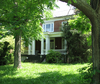 | December 30, 1993 (#93001460) | 2020 Whitelake Dr. 38°14′25″N 77°30′51″W / 38.240278°N 77.514167°W / 38.240278; -77.514167 (Fairview) | Fredericksburg | Federal-style home built in 1837 by Samuel Alsop, Jr., architect and builder who designed a number of buildings in Spotsylvania |
| 3 | Fredericksburg and Spotsylvania County Battlefields Memorial National Military Park | 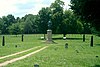 | October 15, 1966 (#66000046) | Fredericksburg and western and southwestern areas in Spotsylvania County 38°17′34″N 77°28′09″W / 38.292778°N 77.469167°W / 38.292778; -77.469167 (Fredericksburg and Spotsylvania County Battlefields Memorial National Military Park) | Fredericksburg | Extends into Fredericksburg and other nearby counties. |
| 4 | Kenmore | 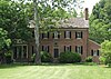 | June 24, 1993 (#93000569) | 8300 State Route 208 38°11′07″N 77°35′48″W / 38.185278°N 77.596667°W / 38.185278; -77.596667 (Kenmore) | Spotsylvania Courthouse | Also known as Kenmore Woods - not to be confused with Kenmore (Fredericksburg, Virginia) |
| 5 | La Vista | 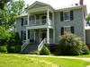 | December 1, 1997 (#97001508) | 4420 Guinea Station Rd. 38°10′07″N 77°29′27″W / 38.168611°N 77.490833°W / 38.168611; -77.490833 (La Vista) | Guinea | Federal / Greek revival house built in 1838. |
| 6 | La Vue |  | January 11, 1994 (#93001459) | Southern side of U.S. Route 17 at its junction with the Richmond, Fredericksburg and Potomac Railroad tracks 38°13′09″N 77°26′35″W / 38.219167°N 77.443056°W / 38.219167; -77.443056 (La Vue) | Fredericksburg | Formerly known as Prospect Vue. The home was built in 1848 for John Alsop. |
| 7 | Lansdowne |  | February 5, 2013 (#12001270) | 4919 Lansdowne Rd. 38°15′17″N 77°28′22″W / 38.254861°N 77.472778°W / 38.254861; -77.472778 (Lansdowne) | Fredericksburg | |
| 8 | Massaponax Baptist Church | 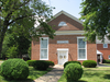 | January 24, 1991 (#90002137) | Junction of U.S. Route 1 and Massaponax Church Rd. 38°11′37″N 77°30′36″W / 38.193611°N 77.510000°W / 38.193611; -77.510000 (Massaponax Baptist Church) | Massaponax | Built in 1859 and site of council of war with Grant, Meade, and other Union generals |
| 9 | Oakley |  | May 22, 2002 (#02000533) | 10000 Corbin Ln. 38°14′08″N 77°42′25″W / 38.235556°N 77.706944°W / 38.235556; -77.706944 (Oakley) | Spotsylvania Courthouse | Built in 1828 by Samuel Alsop, Jr. |
| 10 | Prospect Hill | 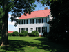 | September 9, 1982 (#82004597) | 1507 Monrovia Rd. 38°07′28″N 77°52′43″W / 38.124583°N 77.878611°W / 38.124583; -77.878611 (Prospect Hill) | Mineral | Built in 1811/1812 for local politician Waller Holladay. Plantation was the site of the 1st Post Office in Spotsylvania County (1809) |
| 11 | Rapidan Dam Canal of the Rappahannock Navigation | Upload image | July 26, 1973 (#73002063) | Extending from the mouth of the Rapidan River down the Rappahannock River for 1.5 miles (2.4 km) 38°21′07″N 77°36′17″W / 38.351944°N 77.604722°W / 38.351944; -77.604722 (Rapidan Dam Canal of the Rappahannock Navigation) | Spotsylvania Courthouse | Best preserved section of the Rappahannock Navigation, a 19th-century effort to open 50 miles of the Rappahannock River to navigation |
| 12 | St. Julien |  | June 5, 1975 (#75002038) | South of Fredericksburg between State Route 2 and Thornton Rolling Rd. 38°13′08″N 77°24′50″W / 38.218750°N 77.413750°W / 38.218750; -77.413750 (St. Julien) | Fredericksburg | Home of prominent Virginia republican Francis Taliaferro Brooke[6] |
| 13 | Spotsylvania Court House Historic District |  | September 8, 1983 (#83003317) | State Route 208 38°12′00″N 77°35′16″W / 38.200000°N 77.587778°W / 38.200000; -77.587778 (Spotsylvania Court House Historic District) | Spotsylvania Courthouse | |
| 14 | Stirling |  | May 5, 1989 (#89000366) | Guinea Station Rd. at Interstate 95 38°10′54″N 77°30′10″W / 38.181528°N 77.502778°W / 38.181528; -77.502778 (Stirling) | Massaponax | |
| 15 | Sylvania Plant Historic District |  | February 13, 2020 (#100004980) | 11900, 11800, and 11700 blocks of Main St. 38°16′44″N 77°26′54″W / 38.278889°N 77.448333°W / 38.278889; -77.448333 (Sylvania Plant Historic District) | Fredericksburg | |
| 16 | Tubal Furnace Archeological Site |  | October 19, 1982 (#82001825) | Address Restricted 38°19′52″N 77°36′41″W / 38.331111°N 77.611389°W / 38.331111; -77.611389 (Tubal Furnace Archeological Site) | Chancellor | Oldest iron furnace in Virginia, one of the oldest in the United States |
| 17 | Walnut Grove | 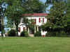 | August 20, 2004 (#04000889) | Belmont Rd., west of Spotsylvania[7] 38°09′50″N 77°51′54″W / 38.163750°N 77.865000°W / 38.163750; -77.865000 (Walnut Grove) | Spotsylvania Courthouse | Built in 1840 by William A. Jennings for Jonathan Johnson |
Former listing
| [3] | Name on the Register | Image | Date listed | Date removed | Location | City or town | Description |
|---|---|---|---|---|---|---|---|
| 1 | Bloomsbury Farm |  | May 8, 2000 (#00000479) | February 7, 2017 | 9736 Courthouse Rd. 38°14′02″N 77°33′58″W / 38.233889°N 77.566111°W / 38.233889; -77.566111 (Bloomsbury Farm) | Spotsylvania Courthouse | Also known as Harris Farm;[8] site of the Harris Farm Engagement during the American Civil War.[9] Demolished in 2014.[10] |
See also
Wikimedia Commons has media related to National Register of Historic Places in Spotsylvania County, Virginia.
- List of National Historic Landmarks in Virginia
- National Register of Historic Places listings in Virginia
- National Register of Historic Places listings in Fredericksburg, Virginia
References
- ^ The latitude and longitude information provided in this table was derived originally from the National Register Information System, which has been found to be fairly accurate for about 99% of listings. Some locations in this table may have been corrected to current GPS standards.
- ^ National Park Service, United States Department of the Interior, "National Register of Historic Places: Weekly List Actions", retrieved June 14, 2024.
- ^ a b Numbers represent an alphabetical ordering by significant words. Various colorings, defined here, differentiate National Historic Landmarks and historic districts from other NRHP buildings, structures, sites or objects.
- ^ "National Register Information System". National Register of Historic Places. National Park Service. April 24, 2008.
- ^ The eight-digit number below each date is the number assigned to each location in the National Register Information System database, which can be viewed by clicking the number.
- ^ "National Register of Historic Places Nomination Form: St. Julien" (PDF). Virginia Department of Historic Resources. 1975. Retrieved January 21, 2009.
- ^ Location derived from its coordinates; the NRIS lists the site as "Address Restricted" but provides coordinates
- ^ "National Register Information System". National Register of Historic Places. National Park Service. July 9, 2010.
- ^ "Bloomsbury Farm" (PDF). National Register of Historic Places Nomination Form. Virginia Department of Historic Resources. Retrieved 29 May 2012.
- ^ Branscome, Jeff (24 December 2014). "Historic Spotsylvania Farm House Demolished". Fredericksburg.com. Retrieved 24 July 2016.
- v
- t
- e
by county
- Accomack
- Albemarle
- Alleghany
- Amelia
- Amherst
- Appomattox
- Arlington
- Augusta
- Bath
- Bedford
- Bland
- Botetourt
- Brunswick
- Buchanan
- Buckingham
- Campbell
- Caroline
- Carroll
- Charles City
- Charlotte
- Chesterfield
- Clarke
- Craig
- Culpeper
- Cumberland
- Dickenson
- Dinwiddie
- Essex
- Fairfax
- Fauquier
- Floyd
- Fluvanna
- Franklin
- Frederick
- Giles
- Gloucester
- Goochland
- Grayson
- Greene
- Greensville
- Halifax
- Hanover
- Henrico
- Henry
- Highland
- Isle Of Wight
- James City
- King and Queen
- King George
- King William
- Lancaster
- Lee
- Loudoun
- Louisa
- Lunenburg
- Madison
- Mathews
- Mecklenburg
- Middlesex
- Montgomery
- Nelson
- New Kent
- Northampton
- Northumberland
- Nottoway
- Orange
- Page
- Patrick
- Pittsylvania
- Powhatan
- Prince Edward
- Prince George
- Prince William
- Pulaski
- Rappahannock
- Richmond
- Roanoke
- Rockbridge
- Rockingham
- Russell
- Scott
- Shenandoah
- Smyth
- Southampton
- Spotsylvania
- Stafford
- Surry
- Sussex
- Tazewell
- Warren
- Washington
- Westmoreland
- Wise
- Wythe
- York

by city
- Alexandria
- Bristol
- Buena Vista
- Charlottesville
- Chesapeake
- Colonial Heights
- Covington
- Danville
- Emporia
- Fairfax
- Falls Church
- Franklin
- Fredericksburg
- Galax
- Hampton
- Harrisonburg
- Hopewell
- Lexington
- Lynchburg
- Manassas
- Manassas Park
- Martinsville
- Newport News
- Norfolk
- Norton
- Petersburg
- Poquoson (no listings)
- Portsmouth
- Radford
- Richmond
- Roanoke
- Salem
- Staunton
- Suffolk
- Virginia Beach
- Waynesboro
- Williamsburg
- Winchester
Municipalities and communities of Spotsylvania County, Virginia, United States | ||
|---|---|---|
County seat: Spotsylvania Courthouse | ||
| CDPs |  | |
| Unincorporated communities |
| |
| Footnotes | ‡This populated place also has portions in an adjacent county or counties | |
| ||


