National Register of Historic Places listings in the West Texas region of Texas
This is a list of the National Register of Historic Places listings in Texas's Northwest region.
The West Texas region is an area of 30 counties defined by the Texas Comptroller for economic reporting in 2022, as mapped here.
The region included 2020 population of 650,000, or 2 percent of Texas' population.[1]
Map all coordinates using OpenStreetMap
Download coordinates as:
- KML
- GPX (all coordinates)
- GPX (primary coordinates)
- GPX (secondary coordinates)
To see all locations together in a map, click on "Map all coordinates using OpenSourceMap" at right.
Andrews County
| [2] | Name on the Register[3] | Image | Date listed[4] | Location | City or town | Description |
|---|---|---|---|---|---|---|
| 1 | Andrews Lake Sites | Upload image | November 22, 1978 (#78002886) | Address restricted[5] | Andrews |
Borden County
(has no NRHP listings)
Coke County
| [2] | Name on the Register | Image | Date listed[4] | Location | City or town | Description |
|---|---|---|---|---|---|---|
| 1 | Coke County Jail | 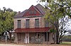 | December 23, 2004 (#04001395) | 6th at Chadbourne 31°53′34″N 100°29′16″W / 31.892778°N 100.487778°W / 31.892778; -100.487778 (Coke County Jail) | Robert Lee | |
| 2 | Fort Chadbourne | 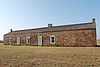 | April 2, 1973 (#73001962) | Off US 277 near Runnels and Coke county line 32°02′07″N 100°14′48″W / 32.035278°N 100.246667°W / 32.035278; -100.246667 (Fort Chadbourne) | Bronte |
Concho County
| [2] | Name on the Register | Image | Date listed[4] | Location | City or town | Description |
|---|---|---|---|---|---|---|
| 1 | Bishop Site |  | June 17, 1977 (#77001434) | Address restricted[5] | Salt Gap | |
| 2 | Concho County Courthouse |  | November 7, 1977 (#77001433) | Public Sq. 31°30′30″N 99°55′11″W / 31.508333°N 99.919722°W / 31.508333; -99.919722 (Concho County Courthouse) | Paint Rock | State Antiquities Landmark, Recorded Texas Historic Landmark |
| 3 | Eola School |  | December 22, 2005 (#05001458) | 12119 FM 381 31°24′08″N 100°05′19″W / 31.402222°N 100.088611°W / 31.402222; -100.088611 (Eola School) | Eola | |
| 4 | Paint Rock Indian Pictograph Site | | June 21, 1971 (#71000927) | Address restricted[5] | Paint Rock |
Crane County
(has no NRHP listings)
Crockett County
| [2] | Name on the Register | Image | Date listed[4] | Location | City or town | Description |
|---|---|---|---|---|---|---|
| 1 | Camp Melvin Site | | November 15, 1978 (#78002909) | Address restricted[5] | Iraan | |
| 2 | Ira and Wilma Carson House |  | September 26, 2002 (#02001062) | 1103 Avenue C 30°42′35″N 101°11′58″W / 30.709861°N 101.199514°W / 30.709861; -101.199514 (Ira and Wilma Carson House) | Ozona | |
| 3 | Crockett County Courthouse |  | December 27, 1974 (#74002066) | 907 Ave. D 30°42′39″N 101°12′02″W / 30.710903°N 101.200486°W / 30.710903; -101.200486 (Crockett County Courthouse) | Ozona | State Antiquities Landmark, Recorded Texas Historic Landmark |
| 4 | Fort Lancaster |  | March 11, 1971 (#71000928) | 10 mi. E of Sheffield on U.S. 290 30°39′58″N 101°41′46″W / 30.666111°N 101.696111°W / 30.666111; -101.696111 (Fort Lancaster) | Sheffield | State Historic Site, State Antiquities Landmark |
| 5 | Harris Ranch Petroglyph Site 41 CX 110 | | May 5, 1978 (#78002908) | Address restricted[5] | Iraan | |
| 6 | Live Oak Creek Archeological District | | April 2, 1976 (#76002018) | Address restricted[5] | Sheffield | |
| 7 | Turkey Roost Petroglyph Site | | October 19, 1978 (#78002910) | Address restricted[5] | Ozona |
Dawson County
| [2] | Name on the Register | Image | Date listed[4] | Location | City or town | Description |
|---|---|---|---|---|---|---|
| 1 | Lamesa Farm Workers Community Historic District |  | August 9, 1993 (#93000771) | Approx 1 mile north of the junction of US 87 and US 180 32°43′08″N 101°55′04″W / 32.7190°N 101.9178°W / 32.7190; -101.9178 (Lamesa Farm Workers Community Historic District) | Los Ybanez |
Ector County
| [2] | Name on the Register | Image | Date listed[4] | Location | City or town | Description |
|---|---|---|---|---|---|---|
| 1 | White-Pool House | 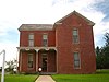 | January 8, 1980 (#80004099) | 112 E. Murphy St. 31°50′31″N 102°21′52″W / 31.842083°N 102.364444°W / 31.842083; -102.364444 (White-Pool House) | Odessa | State Antiquities Landmark, Recorded Texas Historic Landmark |
Gaines County
(has no NRHP listings)
Glasscock County
| [2] | Name on the Register | Image | Date listed[4] | Location | City or town | Description |
|---|---|---|---|---|---|---|
| 1 | Glasscock County Courthouse and Jail | 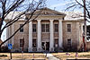 | March 21, 2011 (#11000129) | 117 E. Currie St. 31°51′49″N 101°28′49″W / 31.863488°N 101.480377°W / 31.863488; -101.480377 (Glasscock County Courthouse and Jail) | Garden City | State Antiquities Landmark, Recorded Texas Historic Landmark |
Howard County
| [2] | Name on the Register | Image | Date listed[4] | Location | City or town | Description |
|---|---|---|---|---|---|---|
| 1 | Big Spring Hospital | 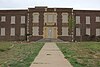 | October 6, 2023 (#100009404) | 810 Goliad St. 32°14′56″N 101°28′11″W / 32.2490°N 101.4696°W / 32.2490; -101.4696 (Big Spring Hospital) | Big Spring | |
| 2 | Big Spring Veterans Administration Hospital | 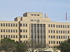 | October 24, 2022 (#100008282) | 300 Veterans Blvd. 32°13′54″N 101°28′18″W / 32.2316°N 101.4718°W / 32.2316; -101.4718 (Big Spring Veterans Administration Hospital) | Big Spring | |
| 3 | Petroleum Building | Upload image | April 21, 2021 (#100006397) | 111 Scurry St. 32°15′12″N 101°28′42″W / 32.2532°N 101.4783°W / 32.2532; -101.4783 (Petroleum Building) | Big Spring | |
| 4 | Potton-Hayden House | 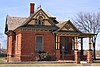 | April 14, 1975 (#75001992) | SW corner Gregg and 2nd Sts. 32°15′00″N 101°28′42″W / 32.25°N 101.4783°W / 32.25; -101.4783 (Potton-Hayden House) | Big Spring | State Antiquities Landmark, Recorded Texas Historic Landmark |
| 5 | Settles Hotel |  | April 16, 2013 (#13000207) | 200 E. 3rd St. 32°15′10″N 101°28′31″W / 32.2528°N 101.4753°W / 32.2528; -101.4753 (Settles Hotel) | Big Spring | Recorded Texas Historic Landmark |
Irion County
| [2] | Name on the Register | Image | Date listed[4] | Location | City or town | Description |
|---|---|---|---|---|---|---|
| 1 | Irion County Courthouse |  | August 29, 1977 (#77001455) | Public Sq. 31°16′47″N 100°47′41″W / 31.279722°N 100.794722°W / 31.279722; -100.794722 (Irion County Courthouse) | Sherwood |
Kimble County
| [2] | Name on the Register | Image | Date listed[4] | Location | City or town | Description |
|---|---|---|---|---|---|---|
| 1 | Brambletye | 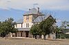 | July 15, 1982 (#82004511) | Off SR 2291 30°33′51″N 99°51′21″W / 30.5642°N 99.8558°W / 30.5642; -99.8558 (Brambletye) | Junction | Recorded Texas Historic Landmark[6] |
| 2 | Kimble County Courthouse | 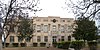 | August 12, 2021 (#100006858) | 501 Main St. 30°29′20″N 99°45′57″W / 30.4890°N 99.7659°W / 30.4890; -99.7659 (Kimble County Courthouse) | Junction | [7][8] |
| 3 | State Highway 27 Bridge at Johnson Fork | 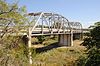 | October 10, 1996 (#96001113) | I-10, .6 mi. W of jct. with FM 2169 30°25′34″N 99°40′47″W / 30.4261°N 99.6797°W / 30.4261; -99.6797 (State Highway 27 Bridge at Johnson Fork) | Junction | [9] |
| 4 | State Highway 27 Bridge at the South Llano River |  | October 10, 1996 (#96001124) | Loop 481, .2 mi. E of 6th St. 30°29′16″N 99°45′45″W / 30.4878°N 99.7625°W / 30.4878; -99.7625 (State Highway 27 Bridge at the South Llano River) | Junction | [10] |
Loving County
| [2] | Name on the Register | Image | Date listed[4] | Location | City or town | Description |
|---|---|---|---|---|---|---|
| 1 | Loving County Courthouse | 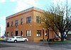 | May 10, 2006 (#06000362) | Bounded by Pecos St., Collins St., Dallas St., and TX 302 31°42′23″N 103°35′55″W / 31.706389°N 103.598611°W / 31.706389; -103.598611 (Loving County Courthouse) | Mentone |
Martin County
| [2] | Name on the Register | Image | Date listed[4] | Location | City or town | Description |
|---|---|---|---|---|---|---|
| 1 | Carmelite Monastery | Upload image | November 3, 1999 (#99000566) | 400 E. Carpenter St. 32°08′02″N 101°47′21″W / 32.133889°N 101.789167°W / 32.133889; -101.789167 (Carmelite Monastery) | Stanton | Recorded Texas Historic Landmark |
Mason County
| [2] | Name on the Register | Image | Date listed[4] | Location | City or town | Description |
|---|---|---|---|---|---|---|
| 1 | Heinrich and Fredericka Hasse House |  | March 14, 1990 (#90000336) | TX 29, W of Art 30°44′21″N 99°07′16″W / 30.739167°N 99.121111°W / 30.739167; -99.121111 (Heinrich and Fredericka Hasse House) | Art | |
| 2 | Mason Historic District |  | September 17, 1974 (#74002086) | Irregular pattern along both sides of U.S. 87 and TX 29 30°44′56″N 99°13′27″W / 30.748889°N 99.224167°W / 30.748889; -99.224167 (Mason Historic District) | Mason | Boundary increase on Oct. 16, 1991 (#91001526); includes State Antiquities Landmark and numerous Recorded Texas Historic Landmarks |
| 3 | Reynolds-Seaquist House |  | November 20, 1974 (#74002087) | 400 Broad St. 30°45′05″N 99°13′54″W / 30.751389°N 99.231667°W / 30.751389; -99.231667 (Reynolds-Seaquist House) | Mason | Recorded Texas Historic Landmark; part of Mason Historic District |
| 4 | State Highway 9 Bridge at the Llano River |  | October 10, 1996 (#96001128) | US 87, 10 mi (16 km). S of TX 29 30°39′40″N 99°06′34″W / 30.661111°N 99.109444°W / 30.661111; -99.109444 (State Highway 9 Bridge at the Llano River) | Mason |
McCulloch County
| [2] | Name on the Register | Image | Date listed[4] | Location | City or town | Description |
|---|---|---|---|---|---|---|
| 1 | McCulloch County Courthouse | 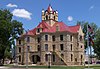 | December 16, 1977 (#77001515) | Public Sq. 31°08′06″N 99°20′05″W / 31.135°N 99.334722°W / 31.135; -99.334722 (McCulloch County Courthouse) | Brady | State Antiquities Landmark, Recorded Texas Historic Landmark |
| 2 | Old McCulloch County Jail |  | April 3, 1975 (#75002073) | 117 N. High St. 31°08′07″N 99°20′12″W / 31.135278°N 99.336667°W / 31.135278; -99.336667 (Old McCulloch County Jail) | Brady | Recorded Texas Historic Landmark |
Menard County
| [2] | Name on the Register | Image | Date listed[4] | Location | City or town | Description |
|---|---|---|---|---|---|---|
| 1 | Fort McKavett Historic District |  | July 14, 1971 (#71000955) | S bank of the San Saba River 30°49′43″N 100°06′27″W / 30.828611°N 100.1075°W / 30.828611; -100.1075 (Fort McKavett Historic District) | Fort McKavett | Texas State Historic Site, includes Recorded Texas Historic Landmark |
| 2 | Menard County Courthouse | 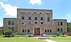 | September 12, 2003 (#03000935) | 206 E. San Saba St. 30°54′55″N 99°47′02″W / 30.915278°N 99.783889°W / 30.915278; -99.783889 (Menard County Courthouse) | Menard | State Antiquities Landmark, Recorded Texas Historic Landmark |
| 3 | Site of Presidio San Luis de las Amarillas |  | August 25, 1972 (#72001369) | 1 mile west of Menard 30°55′21″N 99°48′06″W / 30.9225°N 99.801667°W / 30.9225; -99.801667 (Site of Presidio San Luis de las Amarillas) | Menard | State Antiquities Landmark |
Midland County
| [2] | Name on the Register | Image | Date listed[4] | Location | City or town | Description |
|---|---|---|---|---|---|---|
| 1 | Brown-Dorsey House | 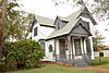 | June 17, 1982 (#82004516) | 213 N. Weatherford 31°59′55″N 102°04′19″W / 31.998611°N 102.071944°W / 31.998611; -102.071944 (Brown-Dorsey House) | Midland | Recorded Texas Historic Landmark |
| 2 | George W. Bush Childhood Home | 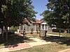 | July 28, 2004 (#04000768) | 1412 W. Ohio 32°00′02″N 102°05′24″W / 32.000556°N 102.09°W / 32.000556; -102.09 (George W. Bush Childhood Home) | Midland | Recorded Texas Historic Landmark |
| 3 | Midland Tower |  | January 27, 2015 (#14001228) | 223 West Wall Street 31°59′50″N 102°04′36″W / 31.997206°N 102.076565°W / 31.997206; -102.076565 (Midland Tower) | Midland | |
| 4 | Fred and Juliette Turner House | 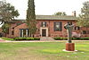 | August 15, 1988 (#88001148) | 1705 W. Missouri 31°59′36″N 102°05′29″W / 31.993333°N 102.091389°W / 31.993333; -102.091389 (Fred and Juliette Turner House) | Midland | |
| 5 | Vaughn Building |  | June 7, 2016 (#16000352) | 400 W. Texas Ave. 31°59′55″N 102°04′42″W / 31.998647°N 102.078439°W / 31.998647; -102.078439 (Vaughn Building) | Midland | [11] |
Pecos County
| [2] | Name on the Register | Image | Date listed[4] | Location | City or town | Description |
|---|---|---|---|---|---|---|
| 1 | Canon Ranch Archeological District | | August 11, 1982 (#82004519) | Address restricted[5] | Sheffield | |
| 2 | Canon Ranch Railroad Eclipse Windmill | 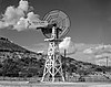 | September 22, 1977 (#77001465) | West of Sheffield on Canon Ranch 30°44′44″N 101°58′30″W / 30.745556°N 101.975°W / 30.745556; -101.975 (Canon Ranch Railroad Eclipse Windmill) | Sheffield | |
| 3 | Fort Stockton Historic District |  | April 2, 1973 (#73001971) | E edge of town 30°53′15″N 102°52′32″W / 30.8875°N 102.875556°W / 30.8875; -102.875556 (Fort Stockton Historic District) | Fort Stockton | Contains Recorded Texas Historic Landmarks |
Reagan County
| [2] | Name on the Register | Image | Date listed[4] | Location | City or town | Description |
|---|---|---|---|---|---|---|
| 1 | Old Reagan County Courthouse | 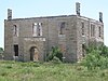 | May 5, 1978 (#78002976) | Off SH 137 31°24′23″N 101°33′56″W / 31.406389°N 101.565556°W / 31.406389; -101.565556 (Old Reagan County Courthouse) | Stiles | State Antiquities Landmark, Recorded Texas Historic Landmark |
Reeves County
(has no NRHP listings)
Schleicher County
| [2] | Name on the Register | Image | Date listed[4] | Location | City or town | Description |
|---|---|---|---|---|---|---|
| 1 | Mittel Site | | January 4, 1990 (#89002278) | Address restricted[5] | Eldorado | Smithsonian trinomial 41SL15 |
Sterling County
| [2] | Name on the Register | Image | Date listed[4] | Location | City or town | Description |
|---|---|---|---|---|---|---|
| 1 | Sterling City Gulf, Colorado & Santa Fe Railway Passenger Depot | 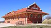 | October 21, 2020 (#100005690) | 415 Stadium Ave. 31°50′32″N 100°59′04″W / 31.8421°N 100.9845°W / 31.8421; -100.9845 (Sterling City Gulf, Colorado & Santa Fe Railway Passenger Depot) | Sterling City |
Sutton County
| [2] | Name on the Register | Image | Date listed[4] | Location | City or town | Description |
|---|---|---|---|---|---|---|
| 1 | deBerry Ranch | Upload image | February 21, 2011 (#11000134) | Private Rd. 1105, approximately 1.5 miles east of County Road 108 30°37′33″N 100°41′31″W / 30.625972°N 100.692014°W / 30.625972; -100.692014 (deBerry Ranch) | Sonora vicinity | |
| 2 | Old Mercantile Building |  | January 30, 1978 (#78002979) | 222 Main St. 30°34′18″N 100°38′40″W / 30.571667°N 100.644444°W / 30.571667; -100.644444 (Old Mercantile Building) | Sonora | Recorded Texas Historic Landmark |
| 3 | Sutton County Courthouse | 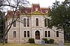 | July 15, 1977 (#77001476) | Public Sq. 30°34′20″N 100°38′37″W / 30.572222°N 100.643611°W / 30.572222; -100.643611 (Sutton County Courthouse) | Sonora | State Antiquities Landmark, Recorded Texas Historic Landmark |
Terrell County
| [2] | Name on the Register[3] | Image | Date listed[4] | Location | City or town | Description |
|---|---|---|---|---|---|---|
| 1 | Bullis' Camp Site | | August 2, 1978 (#78002985) | Address restricted[5] | Dryden | |
| 2 | Geddis Canyon Rock Art Site |  | May 22, 1978 (#78002986) | Address restricted[5] | Dryden | |
| 3 | Meyers Springs Pictograph Site | 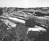 | September 14, 1972 (#72001373) | Address restricted[5] | Dryden | |
| 4 | Wroe Ranch Shelter No. 1 | | January 4, 1990 (#89002279) | Address restricted[5] | Sheffield |
Tom Green County
| [2] | Name on the Register[3] | Image | Date listed[4] | Location | City or town | Description |
|---|---|---|---|---|---|---|
| 1 | Angelo Heights Historic District |  | November 25, 1988 (#88002605) | Roughly bounded by Colorado St., the Concho River, Live Oak St., S. Bishop St., Twohig St., and S. Washington St. 31°27′18″N 100°27′21″W / 31.455°N 100.455833°W / 31.455; -100.455833 (Angelo Heights Historic District) | San Angelo | San Angelo Multiple Resource Area (MRA) |
| 2 | Aztec Cleaners and Laundry Building |  | November 25, 1988 (#88002577) | 119 S. Irving 31°27′39″N 100°26′17″W / 31.460833°N 100.438056°W / 31.460833; -100.438056 (Aztec Cleaners and Laundry Building) | San Angelo | San Angelo MRA |
| 3 | Frederick Beck Farm |  | November 25, 1988 (#88002566) | 1231 Culberson 31°27′44″N 100°25′03″W / 31.462222°N 100.4175°W / 31.462222; -100.4175 (Frederick Beck Farm) | San Angelo | Recorded Texas Historic Landmark, San Angelo MRA |
| 4 | J. B. Blakeney House |  | November 25, 1988 (#88002600) | 438 W. Twohig 31°27′32″N 100°26′42″W / 31.45882°N 100.44504°W / 31.45882; -100.44504 (J. B. Blakeney House) | San Angelo | House completed in 1929, designed by Anton Korn, included in San Angelo MRA. |
| 5 | C. A. Broome House | 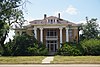 | November 25, 1988 (#88002567) | 123 S. David 31°27′31″N 100°26′43″W / 31.458611°N 100.445278°W / 31.458611; -100.445278 (C. A. Broome House) | San Angelo | San Angelo MRA |
| 6 | R. Wilbur Brown House |  | November 25, 1988 (#88002585) | 1004 Pecos 31°27′34″N 100°27′08″W / 31.459444°N 100.452222°W / 31.459444; -100.452222 (R. Wilbur Brown House) | San Angelo | San Angelo MRA |
| 7 | Building at 113–119 East Concho |  | September 13, 1990 (#88002564) | 113–119 E. Concho 31°27′38″N 100°25′57″W / 31.460556°N 100.4325°W / 31.460556; -100.4325 (Building at 113–119 East Concho) | San Angelo | San Angelo MRA |
| 8 | Clayton House |  | November 25, 1988 (#88002570) | 1101 S. David 31°27′01″N 100°26′36″W / 31.450278°N 100.443333°W / 31.450278; -100.443333 (Clayton House) | San Angelo | San Angelo MRA |
| 9 | Collyns House |  | November 25, 1988 (#88002597) | 315 W. Twohig 31°27′32″N 100°26′32″W / 31.45902°N 100.44228°W / 31.45902; -100.44228 (Collyns House) | San Angelo | San Angelo MRA |
| 10 | Develin House | 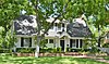 | November 25, 1988 (#88002568) | 913 S. David 31°27′07″N 100°26′36″W / 31.451944°N 100.443333°W / 31.451944; -100.443333 (Develin House) | San Angelo | San Angelo MRA |
| 11 | Eckert House |  | November 25, 1988 (#88002578) | 503 Koberlin 31°28′04″N 100°25′42″W / 31.46776°N 100.428274°W / 31.46776; -100.428274 (Eckert House) | San Angelo | San Angelo MRA |
| 12 | Emmanuel Episcopal Church |  | November 25, 1988 (#88002590) | 3 S. Randolph 31°27′44″N 100°26′27″W / 31.462222°N 100.440833°W / 31.462222; -100.440833 (Emmanuel Episcopal Church) | San Angelo | Recorded Texas Historic Landmark, San Angelo MRA |
| 13 | First Presbyterian Church |  | November 25, 1988 (#88002604) | 32 N. Irving 31°27′52″N 100°26′21″W / 31.464329°N 100.439295°W / 31.464329; -100.439295 (First Presbyterian Church) | San Angelo | San Angelo MRA |
| 14 | O. C. Fisher Federal Building |  | November 25, 1988 (#88002592) | 33 E. Twohig 31°27′42″N 100°26′04″W / 31.46156°N 100.43458°W / 31.46156; -100.43458 (O. C. Fisher Federal Building) | San Angelo | San Angelo MRA |
| 15 | Fort Concho Historic District |  | October 15, 1966 (#66000823) | South edge of downtown San Angelo 31°27′10″N 100°25′45″W / 31.452778°N 100.429167°W / 31.452778; -100.429167 (Fort Concho Historic District) | San Angelo | State Antiquities Landmark; includes multiple Recorded Texas Historic Landmarks |
| 16 | Freeze Building |  | June 20, 1997 (#97000615) | 18 W. Concho Ave. 31°27′36″N 100°26′11″W / 31.45991°N 100.43648°W / 31.45991; -100.43648 (Freeze Building) | San Angelo | |
| 17 | Greater St. Paul AME Church |  | November 25, 1988 (#88002548) | 215 W. 3rd St. 31°27′57″N 100°26′32″W / 31.46577°N 100.44225°W / 31.46577; -100.44225 (Greater St. Paul AME Church) | San Angelo | San Angelo MRA |
| 18 | Hagelstein Commercial Building |  | November 25, 1988 (#88002560) | 616–620 S. Chadbourne 31°27′17″N 100°26′04″W / 31.45481°N 100.43432°W / 31.45481; -100.43432 (Hagelstein Commercial Building) | San Angelo | San Angelo MRA |
| 19 | R. A. Hall House |  | November 25, 1988 (#88002595) | 215 W. Twohig 31°27′34″N 100°26′24″W / 31.459444°N 100.44°W / 31.459444; -100.44 (R. A. Hall House) | San Angelo | San Angelo MRA |
| 20 | Harris Drug Store |  | June 14, 2001 (#01000665) | 114 S. Chadbourne St. 31°27′43″N 100°26′11″W / 31.46197°N 100.43630°W / 31.46197; -100.43630 (Harris Drug Store) | San Angelo | |
| 21 | S. L. Henderson House | 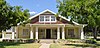 | November 25, 1988 (#88002583) | 1303 S. Park 31°26′54″N 100°26′50″W / 31.448333°N 100.447222°W / 31.448333; -100.447222 (S. L. Henderson House) | San Angelo | San Angelo MRA |
| 22 | Hilton Hotel |  | September 20, 1984 (#84001999) | 36 E. Twohig St. 31°27′43″N 100°26′05″W / 31.46186°N 100.43475°W / 31.46186; -100.43475 (Hilton Hotel) | San Angelo | |
| 23 | Holcomb-Blanton Print Shop | Upload image | November 25, 1988 (#88002554) | 24 W. Beauregard 31°27′44″N 100°26′17″W / 31.46234°N 100.43795°W / 31.46234; -100.43795 (Holcomb-Blanton Print Shop) | San Angelo | San Angelo MRA. Demolished. |
| 24 | House at 1017 South David |  | November 25, 1988 (#88002569) | 1017 S. David 31°27′04″N 100°26′36″W / 31.451111°N 100.443333°W / 31.451111; -100.443333 (House at 1017 South David) | San Angelo | San Angelo MRA |
| 25 | House at 123 Allen |  | November 25, 1988 (#88002601) | 123 Allen 31°27′31″N 100°25′52″W / 31.45854°N 100.43109°W / 31.45854; -100.43109 (House at 123 Allen) | San Angelo | San Angelo MRA |
| 26 | House at 1325 South David |  | November 25, 1988 (#88002571) | 1325 S. David 31°26′51″N 100°26′36″W / 31.4475°N 100.443333°W / 31.4475; -100.443333 (House at 1325 South David) | San Angelo | San Angelo MRA |
| 27 | House at 140 Allen |  | November 25, 1988 (#88002550) | 140 Allen 31°27′33″N 100°25′51″W / 31.45919°N 100.43087°W / 31.45919; -100.43087 (House at 140 Allen) | San Angelo | San Angelo MRA |
| 28 | House at 1621 North Chadbourne |  | November 25, 1988 (#88002559) | 1621 N. Chadbourne 31°28′38″N 100°26′48″W / 31.47722°N 100.44673°W / 31.47722; -100.44673 (House at 1621 North Chadbourne) | San Angelo | San Angelo MRA |
| 29 | House at 221 North Magdalen |  | November 25, 1988 (#88002579) | 221 N. Magdalen 31°28′04″N 100°26′06″W / 31.467778°N 100.435°W / 31.467778; -100.435 (House at 221 North Magdalen) | San Angelo | San Angelo MRA |
| 30 | House at 405 Preusser |  | November 25, 1988 (#88002586) | 405 Preusser 31°27′58″N 100°25′47″W / 31.466111°N 100.429722°W / 31.466111; -100.429722 (House at 405 Preusser) | San Angelo | San Angelo MRA |
| 31 | House at 419 West Avenue C | Upload image | November 25, 1988 (#88002544) | 419 West Ave. C 31°27′15″N 100°26′27″W / 31.454167°N 100.440833°W / 31.454167; -100.440833 (House at 419 West Avenue C) | San Angelo | San Angelo MRA |
| 32 | House at 421 West Twohig | 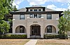 | November 25, 1988 (#88002598) | 421 W. Twohig 31°27′30″N 100°26′37″W / 31.45844°N 100.443611°W / 31.45844; -100.443611 (House at 421 West Twohig) | San Angelo | San Angelo MRA |
| 33 | House at 427 West Twohig |  | September 13, 1990 (#88002599) | 427 W. Twohig 31°27′30″N 100°26′40″W / 31.45837°N 100.44458°W / 31.45837; -100.44458 (House at 427 West Twohig) | San Angelo | San Angelo MRA |
| 34 | House at 521 West Highland Boulevard |  | November 25, 1988 (#88002575) | 521 W. Highland Blvd. 31°27′05″N 100°26′35″W / 31.451375°N 100.443158°W / 31.451375; -100.443158 (House at 521 West Highland Boulevard) | San Angelo | San Angelo MRA |
| 35 | House at 715 Austin |  | November 25, 1988 (#88002551) | 715 Austin 31°27′14″N 100°26′42″W / 31.45400°N 100.44491°W / 31.45400; -100.44491 (House at 715 Austin) | San Angelo | San Angelo MRA |
| 36 | House at 731 Preusser | 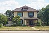 | November 25, 1988 (#88002589) | 731 Preusser 31°27′58″N 100°25′27″W / 31.466111°N 100.424167°W / 31.466111; -100.424167 (House at 731 Preusser) | San Angelo | San Angelo MRA |
| 37 | Household Furniture Co. |  | November 25, 1988 (#88002558) | 11 N. Chadbourne 31°27′51″N 100°26′16″W / 31.46417°N 100.43769°W / 31.46417; -100.43769 (Household Furniture Co.) | San Angelo | San Angelo MRA |
| 38 | Iglesia Santa Maria | 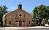 | November 25, 1988 (#88002547) | 7 West Ave. N 31°26′33″N 100°26′04″W / 31.4425°N 100.434444°W / 31.4425; -100.434444 (Iglesia Santa Maria) | San Angelo | San Angelo MRA |
| 39 | Lone Wolf Crossing Bridge | 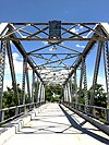 | November 25, 1988 (#88002546) | Ave. K extension, E of Oakes 31°26′45″N 100°25′30″W / 31.445833°N 100.425°W / 31.445833; -100.425 (Lone Wolf Crossing Bridge) | San Angelo | San Angelo MRA |
| 40 | Mason-Hughes House |  | November 25, 1988 (#88002557) | 1104 W. Beauregard 31°27′27″N 100°27′08″W / 31.4575°N 100.452222°W / 31.4575; -100.452222 (Mason-Hughes House) | San Angelo | San Angelo MRA |
| 41 | Masonic Lodge 570 |  | November 25, 1988 (#88002580) | 130 S. Oakes 31°27′44″N 100°26′03″W / 31.462104°N 100.434258°W / 31.462104; -100.434258 (Masonic Lodge 570) | San Angelo | San Angelo MRA |
| 42 | J. T. and Minnie McClelland House |  | November 25, 1988 (#88002576) | 715 W. Highland 31°27′05″N 100°26′42″W / 31.451389°N 100.445°W / 31.451389; -100.445 (J. T. and Minnie McClelland House) | San Angelo | San Angelo MRA |
| 43 | Monogram Square |  | November 25, 1988 (#88002602) | 305 W. Concho 31°27′28″N 100°26′28″W / 31.457778°N 100.441111°W / 31.457778; -100.441111 (Monogram Square) | San Angelo | San Angelo MRA |
| 44 | Montgomery Ward Building | Upload image | November 25, 1988 (#88002553) | 10 W. Beauregard 31°27′45″N 100°26′13″W / 31.4625°N 100.436944°W / 31.4625; -100.436944 (Montgomery Ward Building) | San Angelo | San Angelo MRA |
| 45 | Municipal Swimming Pool | 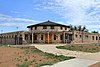 | November 25, 1988 (#88002543) | 18 East Ave. A 31°27′24″N 100°25′59″W / 31.456667°N 100.433056°W / 31.456667; -100.433056 (Municipal Swimming Pool) | San Angelo | Recorded Texas Historic Landmark, San Angelo MRA |
| 46 | Murrah House |  | November 25, 1988 (#88002594) | 212 W. Twohig 31°27′37″N 100°26′24″W / 31.460278°N 100.44°W / 31.460278; -100.44 (Murrah House) | San Angelo | San Angelo MRA |
| 47 | Oakes Hotel Building |  | November 25, 1988 (#88002581) | 204 S. Oakes 31°27′42″N 100°26′03″W / 31.46155°N 100.43408°W / 31.46155; -100.43408 (Oakes Hotel Building) | San Angelo | San Angelo MRA |
| 48 | Princess Ice Cream Co. |  | November 25, 1988 (#88002556) | 217 W. Beauregard 31°27′39″N 100°26′26″W / 31.460833°N 100.440556°W / 31.460833; -100.440556 (Princess Ice Cream Co.) | San Angelo | San Angelo MRA |
| 49 | J. J. Rackley Building |  | June 30, 1983 (#83003163) | 118 S. Chadbourne 31°27′42″N 100°26′10″W / 31.461794°N 100.436204°W / 31.461794; -100.436204 (J. J. Rackley Building) | San Angelo | |
| 50 | Roosevelt Hotel | 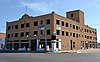 | May 14, 2018 (#100002436) | 50 N Chadbourne St. 31°27′55″N 100°26′15″W / 31.465377°N 100.437568°W / 31.465377; -100.437568 (Roosevelt Hotel) | San Angelo | |
| 51 | San Angelo City Hall |  | November 25, 1988 (#88002563) | City Hall Plaza 31°27′53″N 100°26′21″W / 31.464722°N 100.439167°W / 31.464722; -100.439167 (San Angelo City Hall) | San Angelo | San Angelo MRA |
| 52 | San Angelo National Bank Building |  | December 16, 1982 (#82001740) | 201 S. Chadbourne St. 31°27′40″N 100°26′11″W / 31.46102°N 100.43628°W / 31.46102; -100.43628 (San Angelo National Bank Building) | San Angelo | Bank designed by Anton Korn and built in 1927. |
| 53 | San Angelo National Bank, Johnson and Taylor, and Schwartz and Raas Buildings |  | April 7, 1978 (#78002988) | 20–22, 24, 26 E. Concho Ave. 31°27′38″N 100°26′03″W / 31.460556°N 100.434167°W / 31.460556; -100.434167 (San Angelo National Bank, Johnson and Taylor, and Schwartz and Raas Buildings) | San Angelo | Recorded Texas Historic Landmark |
| 54 | San Angelo Telephone Company Building |  | November 25, 1988 (#88002593) | 14 W. Twohig 31°27′41″N 100°26′11″W / 31.461389°N 100.436389°W / 31.461389; -100.436389 (San Angelo Telephone Company Building) | San Angelo | San Angelo MRA |
| 55 | Santa Fe Passenger Depot |  | November 27, 1989 (#88002561) | 700 S. Chadbourne 31°27′14″N 100°26′05″W / 31.453889°N 100.434722°W / 31.453889; -100.434722 (Santa Fe Passenger Depot) | San Angelo | Recorded Texas Historic Landmark, San Angelo MRA |
| 56 | Santa Fe Railway Freight Depot |  | November 27, 1989 (#88002562) | 700 S. Chadbourne 31°27′16″N 100°26′02″W / 31.454444°N 100.433889°W / 31.454444; -100.433889 (Santa Fe Railway Freight Depot) | San Angelo | Recorded Texas Historic Landmark, San Angelo MRA |
| 57 | William Schneemann House |  | November 25, 1988 (#88002588) | 724 Preusser St. 31°28′01″N 100°25′28″W / 31.466944°N 100.424444°W / 31.466944; -100.424444 (William Schneemann House) | San Angelo | San Angelo MRA |
| 58 | Shepperson House |  | November 25, 1988 (#88002587) | 716 Preusser 31°28′01″N 100°25′33″W / 31.466944°N 100.425833°W / 31.466944; -100.425833 (Shepperson House) | San Angelo | San Angelo MRA |
| 59 | Texas Highway Department Building, Warehouse and Motor Vehicle Division |  | November 25, 1988 (#88002582) | 100 Paint Rock Rd. 31°26′42″N 100°25′08″W / 31.445°N 100.418889°W / 31.445; -100.418889 (Texas Highway Department Building, Warehouse and Motor Vehicle Division) | San Angelo | San Angelo MRA |
| 60 | Tom Green County Courthouse |  | November 25, 1988 (#88002555) | 100 W. Beauregard 31°27′45″N 100°26′22″W / 31.4625°N 100.439444°W / 31.4625; -100.439444 (Tom Green County Courthouse) | San Angelo | San Angelo MRA |
| 61 | Tom Green County Jail |  | October 22, 1976 (#76002246) | US 67 31°27′47″N 100°26′22″W / 31.463056°N 100.439444°W / 31.463056; -100.439444 (Tom Green County Jail) | San Angelo | Demolished in 1977[12] |
| 62 | Twin Mountain Fence Company | Upload image | October 6, 2023 (#100009406) | 7513 South US 67 31°24′46″N 100°32′37″W / 31.41266°N 100.5437°W / 31.41266; -100.5437 (Twin Mountain Fence Company) | San Angelo vicinity | |
| 63 | C. C. Walsh House |  | September 13, 1990 (#88002584) | 922 Pecos 31°27′36″N 100°27′06″W / 31.46°N 100.451667°W / 31.46; -100.451667 (C. C. Walsh House) | San Angelo | San Angelo MRA |
| 64 | Dr. Herbert A. Wardlaw House |  | November 25, 1988 (#88002596) | 233 W. Twohig 31°27′32″N 100°26′31″W / 31.458889°N 100.441944°W / 31.458889; -100.441944 (Dr. Herbert A. Wardlaw House) | San Angelo | San Angelo MRA |
| 65 | West Texas Utilities Office |  | November 25, 1988 (#88002552) | 15 E. Beauregard 31°27′45″N 100°26′08″W / 31.4625°N 100.435556°W / 31.4625; -100.435556 (West Texas Utilities Office) | San Angelo | San Angelo MRA |
| 66 | John C. Westbrook House | Upload image | November 25, 1988 (#88002545) | 600 West Ave. C 31°27′17″N 100°26′17″W / 31.454722°N 100.438056°W / 31.454722; -100.438056 (John C. Westbrook House) | San Angelo | San Angelo MRA |
| 67 | John and Anton Willeke House |  | November 25, 1988 (#88002573) | 941 E. Harris 31°27′53″N 100°25′17″W / 31.46468°N 100.42148°W / 31.46468; -100.42148 (John and Anton Willeke House) | San Angelo | San Angelo MRA |
| 68 | John Willeke Jr. House |  | November 25, 1988 (#88002574) | 1005 E. Harris 31°27′54″N 100°25′16″W / 31.46511°N 100.42099°W / 31.46511; -100.42099 (John Willeke Jr. House) | San Angelo | San Angelo MRA |
| 69 | John Willeke Sr. House | 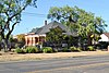 | November 25, 1988 (#88002572) | 931 E. Harris 31°27′54″N 100°25′18″W / 31.46506°N 100.42167°W / 31.46506; -100.42167 (John Willeke Sr. House) | San Angelo | San Angelo MRA |
| 70 | Dr. M. M. Woodward House |  | November 25, 1988 (#88002549) | 44 W. 25th St. 31°29′05″N 100°27′12″W / 31.48478°N 100.45329°W / 31.48478; -100.45329 (Dr. M. M. Woodward House) | San Angelo | San Angelo MRA |
Upton County
(has no NRHP listings)
Ward County
(has no NRHP listings)
Winkler County
| [2] | Name on the Register | Image | Date listed[4] | Location | City or town | Description |
|---|---|---|---|---|---|---|
| 1 | Rig Theater | 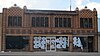 | August 14, 2003 (#03000770) | 213-215 E. Hendricks Blvd. 31°45′21″N 103°09′25″W / 31.755833°N 103.157083°W / 31.755833; -103.157083 (Rig Theater) | Wink |
References
- ^ "The West Texas Region 2022 Regional Report". Texas Comptroller of Public Accounts. Retrieved April 8, 2023.
- ^ a b c d e f g h i j k l m n o p q r s t u v w x Numbers represent an alphabetical ordering by significant words. Various colorings, defined here, differentiate National Historic Landmarks and historic districts from other NRHP buildings, structures, sites or objects.
- ^ a b c "National Register Information System". National Register of Historic Places. National Park Service. July 9, 2010.
- ^ a b c d e f g h i j k l m n o p q r s t u v w x The eight-digit number below each date is the number assigned to each location in the National Register Information System database, which can be viewed by clicking the number.
- ^ a b c d e f g h i j k l m Federal and state laws and practices restrict general public access to information regarding the specific location of this resource. In some cases, this is to protect archeological sites from vandalism, while in other cases it is restricted at the request of the owner. See: Knoerl, John; Miller, Diane; Shrimpton, Rebecca H. (1990), Guidelines for Restricting Information about Historic and Prehistoric Resources, National Register Bulletin, National Park Service, U.S. Department of the Interior, OCLC 20706997.
- ^ "Details - Brambletye - Atlas Number 2082004511 - Atlas: Texas Historical Commission". atlas.thc.state.tx.us. Retrieved May 4, 2024.
- ^ "073 Kimble County". 254 Texas Courthouses. Retrieved May 4, 2024.
- ^ "Details - Kimble County Courthouse - Atlas Number 2100006858 - Atlas: Texas Historical Commission". atlas.thc.state.tx.us. Retrieved May 4, 2024.
- ^ "Details - State Highway 27 Bridge at Johnson Fork - Atlas Number 2096001113 - Atlas: Texas Historical Commission". atlas.thc.state.tx.us. Retrieved May 4, 2024.
- ^ "Details - State Highway 27 Bridge at the South Llano River - Atlas Number 2096001124 - Atlas: Texas Historical Commission". atlas.thc.texas.gov. Retrieved May 4, 2024.
- ^ http://www.thc.state.tx.us/public/upload/preserve/national_register/draft_nominations/Midland,%20Vaughn%20Building%20NR%20SBR.pdf [dead link]
- ^ "The journey — and challenges — of the Tom Green County Jail, from 1875 until today".


