Nevada City Downtown Historic District
Historic district in California, United States
United States historic place
Nevada City Downtown Historic District | |
 | |
   | |
| Location | Roughly bounded by Spring, Bridge, Commercial, York, Washington, Coyote, and Main Sts., Nevada City, California |
|---|---|
| Area | 16 acres (6.5 ha) |
| Built | 1917 |
| Architect | Multiple |
| Architectural style | Moderne, Italianate |
| NRHP reference No. | 85002520[1] |
| Added to NRHP | September 23, 1985 |
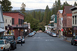
The Nevada City Downtown Historic District is a 16-acre (6.5 ha) historic district in Nevada City within the U.S. state of California. Located in Nevada County, it was listed on the National Register of Historic Places in 1985. It dates from 1917, with examples of Moderne and Italianate architecture.[2] The period of significance is 1856–1917. The historic district covers the downtown section roughly bounded by Spring, Bridge, Commercial, York, Washington, Coyote, and Main Streets. It includes 70 contributing buildings including the National Hotel, which is separately listed on the National Register.[1] Several historical buildings have received California Historical Landmark status, and have been preserved.
Numbering
- Buildings on Broad Street, numbered from 211 to 420
- Buildings on Commercial Street, numbered from 200 to 405
- Buildings on Main Street, numbered from 30 through 308
- Buildings on South Pine Street, numbered from 108 to 203
- Buildings on North Pine Street, numbered from 108-1/2 to 231
- Buildings on Springs Street, numbered from 300 to 325
- Buildings on Church Street, numbered 214 to 222
- Buildings on Washington Street, numbered 310 and 317
Buildings
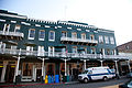
- National Hotel, 211 Broad Street
- Court house in Courthouse Square and city hall Art deco facades are attributable to Works Progress Administration projects.
- St. Canice Catholic Church, 317 Washington Street
- Doris Foley Library for Historical Research (NRHP No. 90001809), 211 (re-numbered 231) North Pine Street, is a Carnegie library.
- Miners Foundry (CHL No. 1012), 325 Spring Street, was the first manufacturing location of the Pelton wheel.
- National Hotel (CHL No. 899), 211 Broad Street, is one of the oldest continuously operating hotels west of the Rocky Mountains.
- Nevada City Firehouse No. 2 is a Neoclassical-Greek Revival style building. The firehouse was built in 1860 and was added to the National Register of Historic Places on May 3, 1974.
- Nevada Brewery (NRHP No. 85002303), 107 Sacramento Street, was used for brewing and serving lager beer to the mining community.
- Nevada Theatre (CHL No. 863), 401 Broad Street, is California's oldest original-use theatre.
- Ott's Assay Office
- The South Yuba Canal Office (CHL No. 832) was the headquarters for the largest network of water flumes and ditches in California.[3] Located at 134 Main Street, it was the headquarters for the largest network of water flumes and ditches in California.[3] It became a California Historical Landmark in May 1970.
Built in 1855, it was originally known as the Potter Building. A two-story brick structure,[4] it was fitted with iron doors and shutters, plus a filigree balcony railing.[5] The company's original ditch was put into use in 1850. The South Yuba Canal is now part of the public lands of the Tahoe National Forest.[6] The South Yuba Canal System is used for delivering domestic and agricultural water to Nevada City and its neighbor Grass Valley. The water also generates electricity in Northern California. It is approximately 18 mi (29 km) in length. Crossing private and National Forest lands, the canal is bordered by conifers and hardwoods.[6]
Gallery
-
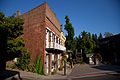
 Corner of Broadway and Pine
 -
 Masonic Building, 108 N Pine Street
 -
 Alpha Building, 210 Broad Street
 -
 Commercial Street
 -
 Left: Ott's Assay Office, 130 Main Street; Right: South Yuba Canal Building
 -
 Historic New York Hotel building, 408 Broad Street
 -
 Left: McGees Annex, 315 Broad St. Right: City Hall, 317 Broad St.
 -
 Nevada Theatre, 401 Broad Street
 -
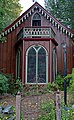
 Nevada City United Methodist Church
 -

-
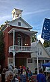 Nevada City Firehouse No. 2, Main Street
 -
 The Independent building, 310 Broad Street
 -
 I.O.O.F building, 225 Broad Street
 -
 Two Room Inn, 431 Broad Street
 -
 Fire House Museum (on far left), 214 Main Street
 -
 A fifteen-ton Pelton wheel in front of the South Yuba Canal Building on Main Street
 -
 Ott's Assay Office with Pelton Wheel monument to the right.
 -
 St. Canice Catholic Church
 -
 Doris Foley Library
 -
-
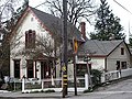 Charles Marsh house


References
Wikimedia Commons has media related to Nevada City Downtown Historic District (California).
- ^ a b "National Register Information System". National Register of Historic Places. National Park Service. July 9, 2010.
- ^ "National Register of Historic Places Inventory/Nomination: Nevada City Downtown Historic District". National Park Service. and accompanying photos
- ^ a b "California State Historical Landmarks in Nevada County". California Environmental Resources Evaluation System. Archived from the original on May 11, 2008. Retrieved May 28, 2010.
- ^ Hoover, Mildred Brooke; Kyle, Douglas E. (2002). Historic spots in California. Stanford University Press. p. 259. ISBN 0-8047-4482-3.
- ^ "Ott's Assay Office & The South Yuba Canal Building". malakoff.com. Retrieved June 30, 2013.
- ^ a b Forest Service, USDA (February 14, 2006). "South Yuba Canal Maintenance Project". Federal Register. 71 (30).
- v
- t
- e
- List of U.S. National Historic Landmarks by state:
- Alabama
- Alaska
- Arizona
- Arkansas
- California
- Colorado
- Connecticut
- Delaware
- Florida
- Georgia
- Hawaii
- Idaho
- Illinois
- Indiana
- Iowa
- Kansas
- Kentucky
- Louisiana
- Maine
- Maryland
- Massachusetts
- Michigan
- Minnesota
- Mississippi
- Missouri
- Montana
- Nebraska
- Nevada
- New Hampshire
- New Jersey
- New Mexico
- New York
- North Carolina
- North Dakota
- Ohio
- Oklahoma
- Oregon
- Pennsylvania
- Rhode Island
- South Carolina
- South Dakota
- Tennessee
- Texas
- Utah
- Vermont
- Virginia
- Washington
- West Virginia
- Wisconsin
- Wyoming
 National Register of Historic Places portal
 Category


