Old Laund Booth
Human settlement in England
- Old Laund Booth
- Pendle
- Lancashire
- North West
- Pendle
- List of places
- UK
- England
- Lancashire
Old Laund Booth is a civil parish in the Pendle district of Lancashire, England. It has a population of 1,459,[1] and contains the villages of Fence and Wheatley Lane.
Old Laund Booth was once a township in the ancient parish of Whalley. This became a civil parish in 1866, forming part of the Burnley Rural District from 1894 (until 1974). Until 1898 when the parish was enlarged, part of Goldshaw Booth and a detached area Higham with West Close Booth, divided the township into two parts with Fence in the eastern and Wheatley Lane and Old Laund hall in the western.[2][3] In 1935 the civil parish of Wheatley Carr Booth was abolished and the area also joined this parish.[4]
The parish adjoins the Pendle parishes of Roughlee Booth, Barrowford, Nelson, Brierfield, Reedley Hallows, Higham-with-West Close Booth and Goldshaw Booth. Higher areas of the parish, north-east of the villages are part of the Forest of Bowland Area of Outstanding Natural Beauty (AONB).[5]
According to the United Kingdom Census 2011, the parish has a population of 1,459,[1] a decrease from 1,586 in the 2001 census.[6]
Media gallery
-
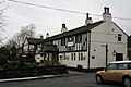 Ye Old Sparrow Hawk, Wheatley Lane
 -
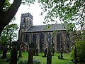 St Anne's Church, Fence
 -
 Inghamite Church, Wheatley Lane
 -
 The White Swan, Wheatley Lane


See also
 Lancashire portal

References
Citations
- ^ a b UK Census (2011). "Local Area Report – Old Laund Booth Parish (1170215073)". Nomis. Office for National Statistics. Retrieved 11 February 2018.
- ^ Lancashire and Furness (Map) (1st ed.). 1 : 10,560. County Series. Ordnance Survey. 1848.
- ^ "Old Laund Booth Tn/CP through time". visionofbritain.org.uk. GB Historical GIS / University of Portsmouth. Retrieved 7 September 2015.
- ^ "Wheatley Carr Booth Tn/CP through time". visionofbritain.org.uk. GB Historical GIS / University of Portsmouth. Retrieved 7 September 2015.
- ^ Forest of Bowland map (Map). forestofbowland.com. Lancashire County Council.
- ^ Office for National Statistics : Census 2001 : Parish Headcounts : Pendle Retrieved 2009-09-18
External links
![]() Media related to Old Laund Booth at Wikimedia Commons
Media related to Old Laund Booth at Wikimedia Commons
- Map of modern parish boundary at Lancashire County Council website
- Old Laund Booth township - British History Online
- Wheatley Carr Booth township - British History Online
- v
- t
- e
Geography of the Borough of Pendle
| Footpaths | |
|---|---|
| Hills | |
| Reservoirs | |
| Waterways | |
| Notes |
|
 | This Lancashire location article is a stub. You can help Wikipedia by expanding it. |
- v
- t
- e


