Oudeschoot
Village in Friesland, Netherlands
Oudeschoot Aldskoat | |
|---|---|
Village | |
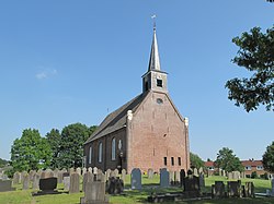 Oudeschoot, chapel: Skoattertsjerke | |
 Flag  Coat of arms | |
 Map of Oudeschoot | |
52°56′5″N 5°57′17″E / 52.93472°N 5.95472°E / 52.93472; 5.95472 | |
| Country |  Netherlands Netherlands |
| Province |  Friesland Friesland |
| Municipality |  Heerenveen Heerenveen |
| Area | |
| • Total | 3.72 km2 (1.44 sq mi) |
| Elevation | 2 m (7 ft) |
| Population (2021)[1] | |
| • Total | 1,500 |
| • Density | 400/km2 (1,000/sq mi) |
| Postal code | 8451[1] |
| Dialing code | 0513 |
Oudeschoot (West Frisian: Aldskoat) is a village in Heerenveen in the province of Friesland, the Netherlands. It had a population of around 1,580 in January 2017.[3]
History
The village was first mentioned in 1299 as van Scoeten. The name means "corner of higher land". Oude (old) has been added to distinguish between Nieuweschoot. In 1299, a nunnery of the German order was founded in Oudeschoot, and has existed until 1580.[4] Oudeschoot used to be the capital of the grietenij (predecessor of a municipality) Schoterland [nl] until 1934. In 1828, the main road from Leeuwarden to Zwolle was built through the village, and was later joined by a railway line.[5] Since 1600, the Skoattermerk, an annual market is held on the second day of Pentecost, and is the oldest extant market in the northern provinces.[6]
The Dutch Reformed church was built in 1752.[5] In 1840, it was home to 452 people.[6] Julia Jan Woutersstichting is a retirement home which was built in 1901 on the grounds of the 1763 manor house Veenwijk. The home is built in Renaissance Revival style and is surrounded by a large park.[5]
Before 1934, Oudeschoot was part of the Schoterland municipality.[6] In 1965, a large part of the village was annexed by Heerenveen.[6]
Gallery
-
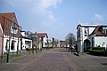 Street view
 -
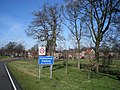 Welcome to Oudeschoot
 -
 Former railway station (1952)


References
- ^ a b c "Kerncijfers wijken en buurten 2021". Central Bureau of Statistics. Retrieved 30 March 2022.
- ^ "Postcodetool for 8451BA". Actueel Hoogtebestand Nederland (in Dutch). Het Waterschapshuis. Retrieved 30 March 2022.
- ^ Kerncijfers wijken en buurten 2017 - CBS Statline
- ^ "Oudeschoot - (geografische naam)". Etymologiebank (in Dutch). Retrieved 30 March 2022.
- ^ a b c Ronald Stenvert & Sabine Broekhoven (2000). "Oudeschoot" (in Dutch). Zwolle: Waanders. ISBN 90 400 9476 4. Retrieved 30 March 2022.
- ^ a b c d "Oudeschoot". Plaatsengids (in Dutch). Retrieved 30 March 2022.
External links
![]() Media related to Oudeschoot at Wikimedia Commons
Media related to Oudeschoot at Wikimedia Commons
- v
- t
- e
Populated places in the municipality of Heerenveen
- Former municipalities:
- Aengwirden
- Schoterland
- Akkrum
- Aldeboarn
- Bontebok
- Gersloot
- Gersloot-Polder [nl]
- Haskerdijken
- Hoornsterzwaag
- Jubbega
- Katlijk
- De Knipe
- Luinjeberd
- Mildam
- Nes
- Nieuwebrug
- Nieuwehorne
- Nieuweschoot
- Oranjewoud
- Oudehorne
- Oudeschoot
- Terband
- Tjalleberd
- Former villages:
- Nijehaske


