Ram Island Ledge Light
Lighthouse in Maine, US
Lighthouse
43°37′53.3″N 70°11′14.5″W / 43.631472°N 70.187361°W / 43.631472; -70.187361Ram Island Ledge Light Station
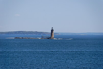
Ram Island Ledge Light is a lighthouse in Casco Bay, Maine, United States, marking the northern end of the main channel leading the harbor of Portland, Maine.
History
The Ram Island Ledges are a series of stone ledges, some of which break the waters at the southern end of Casco Bay, a short way south of Cushing Island. In 1855 an iron spindle was erected to protect sailors from these dangerous underwater ledges. The ledge continued to be the site of repeated shipwrecks. On February 24, 1900, the Allan Line steamship Californian (formerly named the State of California) ran aground on the ledge while en route from Portland to Glasgow, Scotland via Halifax, Nova Scotia. As a result of that accident, the United States Congress appropriated funds to build a lighthouse.
Construction began on May 1, 1903, and was completed in 1905. It is a twin of the Graves Light off Boston. The lighthouse was built of granite quarried from Vinalhaven, Maine. The lighthouse originally included a third-order Fresnel lens. The lighthouse was electrified in 1958, and then automated in 1959. The light was converted to solar power in January 2001. The Ram Island Ledge Light was added to the National Register of Historic Places as Ram Island Ledge Light Station on March 14, 1988, reference number 88000157.[3]
In July 2010, Ram Island Ledge Light was put up for sale to the general public. The minimum bid was $10,000.[4] The property had initially been made available at no charge to other government agencies, educational institutions, and non-profit organizations, but no interest was shown, so bids were opened to the general public. The winning bid, $190,000, came from Jeffrey Florman, a surgeon and resident of Windham, Maine.[5]
-
 Ram Island Ledge Light
 -
 The Ram Island Ledge Light is visible from the Portland Head Light


See also
References
Wikimedia Commons has media related to Ram Island Ledge Light.
- ^ "Historic Light Station Information and Photography: Maine". United States Coast Guard Historian's Office. Archived from the original on 2017-05-01.
- ^ United States Coast Guard (2009). Light List, Volume I, Atlantic Coast, St. Croix River, Maine to Shrewsbury River, New Jersey. p. 62.
- ^ a b "National Register Information System". National Register of Historic Places. National Park Service. March 13, 2009.
- ^ Anderson, Amy (22 July 2010). "Ram Island Ledge light off Cape Elizabeth for sale, in need of care". The Forecaster. Retrieved 27 July 2010.
- ^ Maxwell, Trevor (20 June 2011). "Still in the dark about Ram Island Ledge Light". Portland Press Herald. Retrieved 20 June 2011.
- v
- t
- e
Lighthouses of Maine
- Avery Rock Light
- Baker Island Light
- Bass Harbor Head Light
- Bear Island Light
- Blue Hill Bay Light
- Boon Island Light
- Browns Head Light
- Burnt Coat Harbor Light
- Burnt Island Light
- Cape Elizabeth Lights
- Cape Neddick Light
- Crabtree Ledge Light
- The Cuckolds Light
- Curtis Island Light
- Deer Isle Thorofare Light
- Dice Head Light
- Doubling Point Light
- Doubling Point Range Lights
- Eagle Island Light
- Egg Rock Light
- Fiddler's Reach Fog Signal
- Fort Point Light
- Franklin Island Light
- Goat Island Light
- Goose Rocks Light
- Great Duck Island Light
- Grindel Point Light
- Halfway Rock Light
- Hendricks Head Light
- Heron Neck Light
- Indian Island Light
- Isle au Haut Light
- Ladies Delight Light
- Libby Island Light
- Little River Light
- Lubec Channel Light
- Machias Seal Island*
- Marshall Point Light
- Matinicus Rock Light
- Monhegan Island Light
- Moose Peak Light
- Mount Desert Light
- Narraguagus Light
- Nash Island Light
- Owls Head Light
- Pemaquid Point Light
- Perkins Island Light
- Petit Manan Light
- Pond Island Light
- Portland Breakwater Light
- Portland Head Light
- Prospect Harbor Point Light
- Pumpkin Island Light
- Ram Island Light
- Ram Island Ledge Light
- Rockland Harbor Breakwater Light
- Saddleback Ledge Light
- Saint Croix River Light
- Seguin Light
- Spring Point Ledge Light
- Squirrel Point Light
- Tenants Harbor Light
- Two Bush Island Light
- West Quoddy Head Light
- Whaleback Light
- Whitehead Light
- Whitlocks Mill Light
- Winter Harbor Light
- Wood Island Light

* Disputed territory claimed by Maine but de facto controlled by Canada
| |
|---|---|
| Topics | |
| Lists by state |
|
| Lists by insular areas | |
| Lists by associated state | |
| Other areas | |
| Related | |
| |


Authority control databases | |
|---|---|
| International |
|
| Geographic |
|


