Rincon Peak


Rincon Peak
Location in Arizona
Show map of Arizona
Rincon Peak
Rincon Peak (the United States)
Show map of the United StatesRincon Peak is an 8,482-foot-elevation (2,585-meter) mountain summit in Pima County, Arizona, United States.
Description
Rincon Peak is located in the Rincon Mountains, 25 miles (40 km) east-southeast of Tucson in Saguaro National Park. It ranks as the second-highest peak within the park, second-highest in the range, and fourth-highest in the county.[1][2] The nearest higher neighbor is Mica Mountain 6.84 miles (11 km) to the north.[4] Precipitation runoff from this mountain drains into the Gila River watershed.[4] Topographic relief is significant as the summit rises 3,000 feet (914 meters) above Paige Creek in one mile (1.6 km) and 3,400 feet (1,036 meters) above Rincon Valley in three miles (4.8 km). Because of the higher elevation on Rincon Peak, animals such as the black bear, Mexican spotted owl, Arizona mountain king snake, and white-tailed deer make this mountain their habitat.[6] An ascent of the peak involves an 8.1-mile hike (one-way) with 4,288-feet of elevation gain via the Rincon Peak Trail in combination with the Miller Creek Trail.[2] The mountain's toponym has been officially adopted by the United States Board on Geographic Names.[3] Rincón is Spanish for "corner", referring to the topographic outline of the mountain range.
Climate
According to the Köppen climate classification system, Rincon Peak is located in a Hot-summer Mediterranean climate zone which is surrounded by the Sonoran Desert.[7] This climate supports a pine and conifer forest on the peak's slopes. Climbers can expect afternoon rain and lightning from the seasonal monsoon in late July and August.
See also
 Mountains portal
- List of mountain peaks of Arizona

Gallery
-
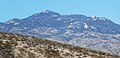 Southwest aspect
 -
 North aspect


References
- ^ a b c d e f "Rincon Peak - 8,482' AZ". listsofjohn.com. Retrieved 2023-11-05.
- ^ a b c Betty Leavengood, Tucson Hiking Guide, Graphic Arts Books, 2013, ISBN 9780871089762
- ^ a b "Rincon Peak". Geographic Names Information System. United States Geological Survey, United States Department of the Interior. Retrieved 2023-11-05.
- ^ a b c "Rincon Peak, Arizona". Peakbagger.com. Retrieved 2023-11-05.
- ^ Learning about the secrets of the Rincon Mountains, Western National Parks Association wnpa.org, Retrieved 2023-11-05.
- ^ Saguaro National Park - Nature, nps.gov, Retrieved 2023-11-05.
- ^ Peel, M. C.; Finlayson, B. L.; McMahon, T. A. (2007). "Updated world map of the Köppen−Geiger climate classification". Hydrol. Earth Syst. Sci. 11. ISSN 1027-5606.
External links
Wikimedia Commons has media related to Rincon Peak.
- Weather forecast: Rincon Peak
- v
- t
- e
(Yavapai County)
- Boundary Cone
- Fortification Hill
- Mount Wilson
- Mount Union
- Castle Dome
- Carr Peak
- Miller Peak
- Aubrey Peak
- Hualapai Peak
- Lime Peak
- Mae West Peaks
- Four Peaks
- Mount Ord
- East End
- McDowell Peak
- Mount McDowell
- Thompson Peak
- Mount Ballard (Arizona)
- Camelback Mountain
- Mummy Mountain
- Piestewa Peak
- South Mountains
- Sunnyslope Mountain
- Ibex Peak
- Mica Mountain
- Rincon Peak
- Agassiz Peak
- Doyle Peak
- Fremont Peak
- Mount Bigelow
- Mount Lemmon
- Pusch Ridge
- Thimble Peak
- Mount Hopkins
- Mount Wrightson
- Mount Turnbull
- Mistake Peak
- Granite Mountain
- Black Dome
- Sentinel Peak
- Tumamoc Hill
- Apache Peak
- Black Mesa (Navajo County)
- Escudilla Mountain
- Mount Baldy
- Agathla Peak
- Agua Caliente Mountains
- Agua Dulce Mountains
- Antelope Hill
- Aquarius Mountains
- Artillery Mountains
- Atascosa Mountains
- Aubrey Hills
- Baboquivari Peak
- Balakai Mesa
- Beaver Dam Mountains
- Belmont Mountains
- Bill Williams Mountain
- Bitsihuitsos Butte
- Black Hills (Greenlee County)
- Black Mesa (Apache-Navajo Counties)
- Black Mesa (Warm Springs)
- Black Mountain (Maricopa County)
- Black Mountain (Pima County)
- Blackjack Mountains
- Bryan Mountains
- Buckskin Mountain (Arizona-Utah)
- Buckskin Mountains (La Paz County)
- Bush Head
- Cabeza Prieta Mountains
- Canelo Hills
- Carrizo Mountains
- Cerro Colorado Mountains
- Chocolate Mountains
- Copper Mountains
- Coyote Mountains
- Date Creek Mountains
- Dome Rock Mountains
- Dos Cabezas Mountains
- Etoi Ki
- Excalibur
- Galiuro Mountains
- Gavilan Peak
- Gila Bend Mountains
- Gila Mountains (Graham County)
- Gila Mountains (Yuma County)
- Goldfield Mountains
- Grand Wash Cliffs
- Granite Mountains
- Granite Wash Mountains
- Growler Mountains
- Gu Achi Peak
- Guadalupe Mountains
- Harcuvar Mountains
- Harquahala Mountains
- House Mountain
- Hunts Mesa
- Isis Temple
- John the Baptist Mountains
- Juniper Mesa
- Kaibab Plateau
- Kofa Mountains
- Laguna Mountains
- Las Guijas Mountains
- Lime Mountain (Maricopa County}
- Little Harquahala Mountains
- Little Rincon Mountains
- Lukachukai Mountains
- Madrean Sky Islands
- Mescal Mountains
- Mineral Mountains
- Moccasin Mountains
- Mohave Mountains
- Mohawk Mountains
- Mount Trumbull
- Muggins Mountains
- Mustang Mountains
- Navajo Mountain
- The Needles
- New River Mountains
- New Water Mountains
- Newton Butte
- Painted Rock Mountains
- Pajarito Mountains
- Patagonia Mountains
- Peacock Mountains
- Picacho Peak
- Picketpost Mountain
- Pinnacle Peak
- Poachie Range
- Poston Butte
- Rawhide Mountains
- Sacaton Mountains
- San Luis Mountains
- Santa Maria Mountains
- Sevenmile Mountains
- Sierra San Antonio
- Sierra Estrella
- Sierra Madre Occidental
- Sierra Pinta
- Silver Bell Mountains
- Squaw Tits
- Sugarloaf Mountain
- Sunset Mountains
- Swisshelm Mountains
- Tempe Butte
- Temple Butte
- Tinajas Altas Mountains
- Tordillo Mountain
- Tortolita Mountains
- Trigo Mountains
- Tule Mountains
- Tumacacori Mountains
- Virgin Mountains
- Vulcan's Throne
- Vulture Mountains
- Waterman Mountains
- Weaver Mountains
- West Silver Bell Mountains
- White Tank Mountains
- Wickenburg Mountains


