Rural Municipality of Kelsey
Rural municipality in Manitoba, Canada
Rural municipality in Manitoba, Canada
53°44′08″N 101°23′42″W / 53.73556°N 101.39500°W / 53.73556; -101.39500 (2016)
R9A 1K6
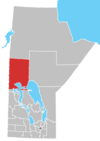
Kelsey is a Manitoban rural municipality embedded within the province's Northern Region. It consists of several disjoint parts. The largest part is Carrot Valley, located around and southwest of The Pas along the Carrot River, but the communities of Wanless and Cranberry Portage, located further north, are also part of the municipality. It is 867.64 km2 large. Also lying in the area around The Pas is the Opaskwayak Cree Nation Indian reserve.
Communities
- Cranberry Portage
- Freshford
- Grace Lake
- Moostissoostikwan
- Ralls Island
- Rocky Lake
- The Pas (independent town)
- Umpherville
- Wanless
- Westray
Demographics
In the 2021 Census of Population conducted by Statistics Canada, Kelsey had a population of 2,181 living in 857 of its 1,041 total private dwellings, a change of -9.8% from its 2016 population of 2,419. With a land area of 850.41 km2 (328.35 sq mi), it had a population density of 2.6/km2 (6.6/sq mi) in 2021.[2]
According to the 2011 National Household Survey,[3] the population of Kelsey is 2,125. The population density was 2.6 per km2. The racial make up of Kelsey is solely made up of Aboriginals (44.0%); First Nations (23.1%) and Metis (20.7%), and Whites (56.0%). The religious make up of Kelsey is; Christian (74.5%), non-religious (25.5%). Every resident of Kelsey is a Canadian citizen. About 4.0% of the population can speak a language that is not recognized as an official language of Canada.
References
- ^ Municipal Officials Directory (PDF). Winnipeg, Manitoba: Manitoba Municipal Relations. 2019.
- ^ "Population and dwelling counts: Canada, provinces and territories, and census subdivisions (municipalities), Manitoba". Statistics Canada. February 9, 2022. Retrieved February 20, 2022.
- ^ "NHS Profile, Kelsey, RM, Manitoba, 2011". Statistics Canada. Retrieved November 23, 2021.
- Map of Kelsey R.M. at Statcan
- Manitoba Municipalities: Rural Municipality of Kelsey
- "Manitoba Communities: Kelsey (Rural Municipality)". Manitoba Historical Society. Retrieved August 19, 2023.
External links
- Official website
Places adjacent to Rural Municipality of Kelsey | ||||||||||||||||
|---|---|---|---|---|---|---|---|---|---|---|---|---|---|---|---|---|
| ||||||||||||||||


- v
- t
- e
Subdivisions of Manitoba
| LGDs |
|---|
| Former towns |
|---|
| Former villages |
|---|
- Alexander
- Alonsa
- Argyle
- Armstrong
- Bifrost – Riverton
- Boissevain – Morton
- Brenda – Waskada
- Brokenhead
- Cartier
- Cartwright – Roblin
- Clanwilliam – Erickson
- Coldwell
- Cornwallis
- Dauphin
- De Salaberry
- Deloraine – Winchester
- Dufferin
- East St. Paul
- Ellice – Archie
- Elton
- Emerson – Franklin
- Ethelbert
- Fisher
- Gilbert Plains
- Gimli
- Glenboro – South Cypress
- Glenella – Lansdowne
- Grahamdale
- Grandview
- Grassland
- Grey
- Hamiota
- Hanover
- Harrison Park
- Headingley
- Kelsey
- Killarney-Turtle Mountain
- La Broquerie
- Lac du Bonnet
- Lakeshore
- Lorne
- Louise
- Macdonald
- McCreary
- Minitonas – Bowsman
- Minto-Odanah
- Montcalm
- Morris
- Mossey River
- Mountain
- Norfolk Treherne
- North Cypress – Langford
- North Norfolk
- Oakland – Wawanesa
- Oakview
- Pembina
- Piney
- Pipestone
- Portage la Prairie
- Prairie Lakes
- Prairie View
- Reynolds
- Rhineland
- Riding Mountain West
- Ritchot
- Riverdale
- Roblin
- Rockwood
- Roland
- Rosedale
- Rossburn
- Rosser
- Russell – Binscarth
- Sifton
- Souris – Glenwood
- Springfield
- St. Andrews
- St. Clements
- St. François Xavier
- St. Laurent
- Ste. Rose
- Stanley
- Ste. Anne
- Stuartburn
- Swan Valley West
- Taché
- Thompson
- Two Borders
- Victoria
- Victoria Beach
- Wallace – Woodworth
- West Interlake
- West St. Paul
- WestLake – Gladstone
- Whitehead
- Whitemouth
- Woodlands
- Yellowhead
 Portal:Canada

| ||
|---|---|---|
| Cities |
|  |
| Towns | ||
| Rural municipalities |
| |
| First Nations | ||
| Indian reserves | ||
| Unorganized areas | ||
| Unincorporated communities |
| |


