San José Province
Province of Costa Rica
Province in Costa Rica

Flag

Seal
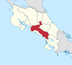


San José (Spanish pronunciation: [saŋ xoˈse]) is a province of Costa Rica. It is located in the central part of the country, and borders (clockwise beginning in the north) the provinces of Alajuela, Heredia, Limón, Cartago and Puntarenas. The provincial and national capital is San José. The province covers an area of 4,965.9 km².[3] and has a population of 1,404,242.[4]
Subdivisions
The province of San José is subdivided into 20 cantons.
Canton (Capital):
- San José (San José)
- Escazú (Escazú)
- Desamparados (Desamparados)
- Puriscal (Santiago)
- Tarrazú (San Marcos)
- Aserrí (Aserrí)
- Mora (Colón)
- Goicoechea (Guadalupe)
- Santa Ana (Santa Ana)
- Alajuelita (Alajuelita)
- Vázquez de Coronado (San Isidro)
- Acosta (San Ignacio)
- Tibás (San Juan)
- Moravia (San Vicente)
- Montes de Oca (San Pedro)
- Turrubares (San Pablo)
- Dota (Santa María)
- Curridabat (Curridabat)
- Pérez Zeledón (San Isidro de El General)
- León Cortés Castro (San Pablo)
See also
- Provinces of Costa Rica
- Greater Metropolitan Area.
References
- ^ inec. "Anuario Estadístico | Instituto Nacional De Estadistica Y Censos" (in Spanish). Inec.cr. Retrieved 2022-04-12.
- ^ "Sub-national HDI - Area Database - Global Data Lab". hdi.globaldatalab.org. Retrieved 2018-09-13.
- ^ Instituto Geográfico Nacional (IGN), 2001,
- ^ Resultados Generales Censo 2011 Archived 2012-10-21 at the Wayback Machine p. 22
External links
![]() Media related to San José Province at Wikimedia Commons
Media related to San José Province at Wikimedia Commons
- v
- t
- e
- Alajuela
- Atenas
- Grecia
- Guatuso
- Los Chiles
- Naranjo
- Orotina
- Palmares
- Poás
- San Carlos
- San Mateo
- San Ramón
- Upala
- Sarchí
- Río Cuarto
- Zarcero
 Costa Rica portal

- Alvarado
- Cartago
- El Guarco
- Jiménez
- La Unión
- Oreamuno
- Paraíso
- Turrialba
- Abangares
- Bagaces
- Cañas
- Carrillo
- Hojancha
- La Cruz
- Liberia
- Nandayure
- Nicoya
- Santa Cruz
- Tilarán
- Barva
- Belén
- Flores
- Heredia
- San Isidro
- San Pablo
- San Rafael
- Santa Bárbara
- Santo Domingo
- Sarapiquí
- Guácimo
- Limón
- Matina
- Pococí
- Siquirres
- Talamanca
- Buenos Aires
- Corredores
- Coto Brus
- Esparza
- Garabito
- Golfito
- Montes de Oro
- Monteverde
- Osa
- Parrita
- Puerto Jiménez
- Puntarenas
- Quepos
- Acosta
- Alajuelita
- Aserrí
- Curridabat
- Desamparados
- Dota
- Escazú
- Goicoechea
- León Cortés Castro
- Montes de Oca
- Mora
- Moravia
- Pérez Zeledón
- Puriscal
- San José
- Santa Ana
- Tarrazú
- Tibás
- Turrubares
- Vázquez de Coronado
Authority control databases | |
|---|---|
| International |
|
| National |
|
| Geographic |
|
| Other |
|
 | This Costa Rican location article is a stub. You can help Wikipedia by expanding it. |
- v
- t
- e


