Santa Rosa del Sur
Municipality and town in Bolívar Department, Colombia

Flag
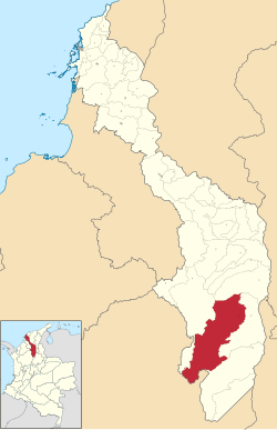
Location of the municipality and town of Santa Rosa del Sur in the Bolívar Department of Colombia
 Colombia
 (2015)
San Rosa del Sur (Spanish pronunciation: [ˈsanta ˈrosa ðel suɾ]) is a town and municipality located in the Bolívar Department, northern Colombia, around 720 km away from the department's capital, Cartagena.
Climate
| Climate data for Santa Rosa del Sur (Sta Rosa D Simiti), elevation 700 m (2,300 ft), (1981–2010) | |||||||||||||
|---|---|---|---|---|---|---|---|---|---|---|---|---|---|
| Month | Jan | Feb | Mar | Apr | May | Jun | Jul | Aug | Sep | Oct | Nov | Dec | Year |
| Mean daily maximum °C (°F) | 30.3 (86.5) | 31.1 (88.0) | 30.5 (86.9) | 29.2 (84.6) | 28.5 (83.3) | 28.6 (83.5) | 29.0 (84.2) | 28.9 (84.0) | 28.4 (83.1) | 28.0 (82.4) | 28.2 (82.8) | 29.2 (84.6) | 29.2 (84.6) |
| Daily mean °C (°F) | 25.3 (77.5) | 25.9 (78.6) | 25.8 (78.4) | 25.1 (77.2) | 24.7 (76.5) | 24.9 (76.8) | 25.0 (77.0) | 24.9 (76.8) | 24.4 (75.9) | 24.0 (75.2) | 24.2 (75.6) | 24.7 (76.5) | 24.9 (76.8) |
| Mean daily minimum °C (°F) | 20.7 (69.3) | 21.2 (70.2) | 21.6 (70.9) | 21.5 (70.7) | 21.3 (70.3) | 21.3 (70.3) | 21.1 (70.0) | 20.9 (69.6) | 20.7 (69.3) | 20.5 (68.9) | 20.8 (69.4) | 20.9 (69.6) | 21.0 (69.8) |
| Average precipitation mm (inches) | 12.7 (0.50) | 24.8 (0.98) | 77.9 (3.07) | 163.2 (6.43) | 234.9 (9.25) | 227.6 (8.96) | 212.1 (8.35) | 240.4 (9.46) | 212.9 (8.38) | 192.8 (7.59) | 124.4 (4.90) | 38.0 (1.50) | 1,756.2 (69.14) |
| Average precipitation days (≥ 1.0 mm) | 2 | 3 | 6 | 12 | 16 | 15 | 14 | 15 | 16 | 16 | 11 | 4 | 127 |
| Average relative humidity (%) | 73 | 71 | 74 | 82 | 85 | 84 | 83 | 84 | 85 | 86 | 85 | 79 | 81 |
| Mean monthly sunshine hours | 248.0 | 194.8 | 164.3 | 123.0 | 136.4 | 159.0 | 201.5 | 189.1 | 147.0 | 130.2 | 147.0 | 207.7 | 2,048 |
| Mean daily sunshine hours | 8.0 | 6.9 | 5.3 | 4.1 | 4.4 | 5.3 | 6.5 | 6.1 | 4.9 | 4.2 | 4.9 | 6.7 | 5.6 |
| Source: Instituto de Hidrologia Meteorologia y Estudios Ambientales[1] | |||||||||||||
| Climate data for Santa Rosa del Sur (Canelos) (1981–2010) | |||||||||||||
|---|---|---|---|---|---|---|---|---|---|---|---|---|---|
| Month | Jan | Feb | Mar | Apr | May | Jun | Jul | Aug | Sep | Oct | Nov | Dec | Year |
| Mean daily maximum °C (°F) | 27.0 (80.6) | 27.6 (81.7) | 27.5 (81.5) | 26.9 (80.4) | 26.8 (80.2) | 27.3 (81.1) | 27.3 (81.1) | 27.5 (81.5) | 26.9 (80.4) | 26.4 (79.5) | 26.0 (78.8) | 26.6 (79.9) | 27 (81) |
| Daily mean °C (°F) | 21.8 (71.2) | 22.1 (71.8) | 22.3 (72.1) | 22.1 (71.8) | 22.2 (72.0) | 22.3 (72.1) | 22.3 (72.1) | 22.4 (72.3) | 22.0 (71.6) | 21.7 (71.1) | 21.6 (70.9) | 21.7 (71.1) | 22.0 (71.6) |
| Mean daily minimum °C (°F) | 16.4 (61.5) | 17.0 (62.6) | 17.8 (64.0) | 18.3 (64.9) | 18.4 (65.1) | 18.1 (64.6) | 17.8 (64.0) | 17.9 (64.2) | 18.0 (64.4) | 18.0 (64.4) | 17.7 (63.9) | 17.1 (62.8) | 17.7 (63.9) |
| Average precipitation mm (inches) | 45.0 (1.77) | 70.4 (2.77) | 116.2 (4.57) | 213.2 (8.39) | 261.4 (10.29) | 224.9 (8.85) | 212.0 (8.35) | 236.9 (9.33) | 237.0 (9.33) | 247.4 (9.74) | 196.8 (7.75) | 92.4 (3.64) | 2,088.5 (82.22) |
| Average precipitation days (≥ 1.0 mm) | 6 | 7 | 11 | 15 | 18 | 16 | 16 | 16 | 17 | 18 | 16 | 9 | 158 |
| Average relative humidity (%) | 85 | 84 | 86 | 88 | 88 | 87 | 86 | 86 | 87 | 88 | 88 | 87 | 87 |
| Mean monthly sunshine hours | 182.9 | 146.8 | 114.7 | 84.0 | 111.6 | 117.0 | 164.3 | 158.1 | 117.0 | 111.6 | 117.0 | 155.0 | 1,580 |
| Mean daily sunshine hours | 5.9 | 5.2 | 3.7 | 2.8 | 3.6 | 3.9 | 5.3 | 5.1 | 3.9 | 3.6 | 3.9 | 5.0 | 4.3 |
| Source: Instituto de Hidrologia Meteorologia y Estudios Ambientales[1] | |||||||||||||
- v
- t
- e
Municipalities in the Bolívar Department
- Achí
- Altos del Rosario
- Arenal del Sur
- Arjona
- Arroyohondo
- Barranco de Loba
- Calamar
- Cantagallo
- El Carmen de Bolívar
- Cartagena
- Cicuco
- Clemencia
- Córdoba
- El Guamo
- Hatillo de Loba
- Magangué
- Mahates
- Margarita
- María La Baja
- Santa Cruz de Mompox
- Montecristo
- Morales
- Norosí
- El Peñón
- Pinillos
- Regidor
- Río Viejo
- San Cristóbal
- San Estanislao
- San Fernando
- San Jacinto
- San Jacinto del Cauca
- San Juan Nepomuceno
- San Martín de Loba
- San Pablo
- Santa Catalina
- Santa Rosa
- Simití
- Soplaviento
- Talaigua Nuevo
- Tiquisio
- Turbaco
- Turbaná
- Villanueva
- Zambrano
- Santa Rosa del Sur

7°58′N 74°03′W / 7.967°N 74.050°W / 7.967; -74.050
 | This Bolívar Department location article is a stub. You can help Wikipedia by expanding it. |
- v
- t
- e
- ^ a b "Promedios Climatológicos 1981–2010" (in Spanish). Instituto de Hidrologia Meteorologia y Estudios Ambientales. Archived from the original on 15 August 2016. Retrieved 3 June 2024.


