Schussen
River in Germany
48°1′19″N 9°39′29″E / 48.02194°N 9.65806°E / 48.02194; 9.65806 • location
• coordinates
• elevation
The Schussen is a 59-kilometre-long (37 mi) tributary of the Bodensee (Lake Constance), which drains to the Rhine, in the southern portion of Upper Swabia in Baden-Württemberg (Germany).
Course

From its source, not far from the Lake Feder, around 1.5 kilometers north of Bad Schussenried, where it runs down the watershed between the Rhine and the Danube, to the Bodensee.
The river passes south of Aulendorf through its own valley in the northern part of the Altdorf Forests, through the Schussen ravine by Durlesbach and by Mochewangen (Wolpertswende), and from there into the broad Schussen Valley. The valley was not created by the river itself, but rather during one of the Ice Ages. From there it runs past the small city of Weingarten, and, further, by Ravensburg and through the district of Meckenbeuren, before it enters the Bodensee water in the region of Eriskirch, at the Eriskircher wetlands.
Tributaries
Several streams enter the Schussen, including the Wolfegger Ach, which originates between Binningen and Niederbiegen (both are part of the community of Baienfurt). Other tributaries include the Scherzach, Scharzach, and the Ravensburg city creek.
Oddities
In the course of its passage through the County of Biberach, the Schussen is the only stream that flows south to the Bodensee; all others flow north to the Danube.
-
 "Schussenbridge", Ravensburg
 -
 Bridge of 1824, Baumgarten
 -
 Bridge of 1828, Eriskirch
 -
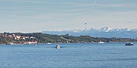
 Close to Lake Constance


References
- ^ a b Map services of the Baden-Württemberg State Office for the Environment, Survey and Conservation (Landesanstalt für Umwelt, Messungen und Naturschutz Baden-Württemberg)
External links
 Media related to Schussen at Wikimedia Commons
- v
- t
- e
Tributaries of the Rhine
(western)
- Vorderrhein
- Aua da Russein
- Schmuèr
- Alpine Rhine
- Vorderrhein
- Tamina
- Alter Rhein
- Rheintaler Binnenkanal
- Lake Constance
- Goldach
- High Rhine
- Thur
- Töss
- Glatt
- Aare
- Sissle
- Ergolz
- Birs
- Birsig
- Upper Rhine
- Ill
- Moder
- Sauer
- Lauter
- Spiegelbach
- Queich
- Speyerbach
- Rehbach
- Isenach
- Eckbach
- Eisbach
- Pfrimm
- Selz
- Middle Rhine
- Welzbach
- Nahe
- Moselle
- Nette
- Brohlbach
- Ahr
- Lower Rhine
- Erft

(eastern)
- Vorderrhein
- Rein da Tuma
- Rein da Curnera
- Rein da Medel
- Rein da Sumvitg
- Glogn
- Rabiusa
- Hinterrhein
- Ragn da Ferrera
- Albula/Alvra
- Alpine Rhine
- Hinterrhein
- Plessur
- Landquart
- Mülbach
- Ill
- Frutz
- Lake Constance
- Dornbirner Ach
- Bregenzer Ach
- Leiblach
- Argen
- Schussen
- Rotach
- Brunnisach
- Lipbach
- Seefelder Aach
- Stockacher Aach
- Radolfzeller Aach
- High Rhine
- Biber
- Wutach
- Alb
- Murg
- Wehra
- Upper Rhine
- Wiese
- Elz
- Kinzig
- Rench
- Acher
- Murg
- Alb
- Pfinz
- Saalbach
- Kraichbach
- Leimbach
- Neckar
- Weschnitz
- Modau
- Main
- Middle Rhine
- Wisper
- Lahn
- Wied
- Lower Rhine
- Sieg
- Wupper
- Düssel
- Ruhr
- Emscher
- Lippe
- IJssel
- Oude IJssel/Issel
- Berkel
- Schipbeek


Authority control databases | |
|---|---|
| International |
|
| National |
|


