Sompolno
Place in Greater Poland Voivodeship, Poland

Coat of arms
 Poland
 (2016)
62-610


Sompolno [sɔmˈpɔlnɔ] is a town in Konin County, Greater Poland Voivodeship, in central Poland, with 3,614 inhabitants (2016).
History
In the 10th century, the area became part of the emerging Polish state under its first historic ruler Mieszko I. In 1242, Duke Casimir I of Kuyavia from the Piast dynasty stayed in Sompolno, and issued a privilege for the Sulejów Abbey there.[1] Sompolno was granted town rights in 1477. It was a royal town, administratively located in the Brześć Kujawski Voivodeship in the Greater Poland Province of the Kingdom of Poland. A route connecting Warsaw with Poznań and Dresden ran through the town in the 18th century and King Augustus III of Poland often traveled that route.[2]
During the German occupation of Poland (World War II), Sompolno was renamed to Deutscheck between 1939–1943 and then later to Deutscheneck between 1943–1945[3] in attempt to erase traces of Polish origin.
Sports
The local football club is GKS Sompolno. It competes in the lower leagues.
Gallery
-
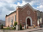 Church of St. Mary Magdalene
 -
 Saint Jerome chapel, 17th century
 -
 Heritage tree Sorbus torminalis
 -
 Heritage tree


References
- ^ Słownik geograficzny Królestwa Polskiego i innych krajów słowiańskich, Tom XV Część II (in Polish). Warszawa. 1902. p. 611.
{{cite book}}: CS1 maint: location missing publisher (link) - ^ "Informacja historyczna". Dresden-Warszawa (in Polish). Retrieved 27 November 2023.
- ^ Vgl. Weblink „Anordnung über Ortsnamenänderung im Reichsgau Wartheland“ - Landkreis Konin
- v
- t
- e
- Sompolno

- Bagno
- Belny
- Biele
- Błonawy
- Bronisława
- Czamża
- Dąbrowa
- Grądy
- Janowice
- Jaźwiny
- Jesionka
- Kazubek
- Klonowa
- Kolonia Lipiny
- Kolonia Wierzbie
- Koszary
- Łagiewniki
- Lubstów
- Lubstówek
- Mąkolno
- Marcinkowo
- Marcjanki
- Marianowo
- Młynek
- Mostki
- Nadjezioro
- Nowa Wieś
- Olszewo
- Ośno Dolne
- Ośno Górne
- Ośno Podleśne
- Ostrówek
- Paprocin
- Piaski
- Płoszewo
- Police
- Przystronie
- Racięcice
- Radowo
- Romanowo
- Ryn
- Siedliska
- Smolarnia
- Smólniki Mostkowskie
- Sompolinek
- Spólnik
- Stefanowo
- Suszewy
- Sycewo
- Szczerkowo
- Wierzbie
- Wroczewo
- Wymysłowo
- Zakrzewek
- Zdrojki
- Zofia
Authority control databases | |
|---|---|
| International |
|
| National |
|
 | This Greater Poland Voivodeship location article is a stub. You can help Wikipedia by expanding it. |
- v
- t
- e


