Tecuamburro


Tecuamburro
Guatemala
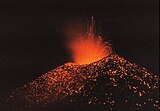
Tecuamburro is a stratovolcano in southern Guatemala, roughly 50 kilometres south east of Guatemala City. The Tecuamburro is an andesitic stratovolcano which formed approximately 38,000 years ago inside a horseshoe-shaped caldera formed by a structural failure in a second, 100,000-year-old stratovolcano, known as Miraflores. The last eruption is believed to have occurred around 960 BCE. At the top of the Tecuamburro is an acidic crater lake around which many hot springs, fumaroles, and boiling mudpots are found.
See also
References
- "Tecuamburro". Global Volcanism Program. Smithsonian Institution.
- v
- t
- e
- Acatenango
- Agua
- Almolonga
- Atitlán
- Chicabal
- Cuilapa-Barbarena
- Fuego
- Jumay
- Moyuta
- Pacaya
- Santa María/Santiaguito
- San Pedro
- Santo Tomás
- Siete Orejas
- Tacaná
- Tajumulco
- Tecuamburro
- Tolimán
- Apoyeque
- Cerro Negro
- Concepción
- Cosigüina
- Maderas
- Masaya
- Mombacho
- Momotombo
- San Cristóbal
- Telica
- Barú
- La Yeguada
- El Valle
Note: volcanoes are ordered from north-west to south-east.
Authority control databases | |
|---|---|
| International |
|
| Geographic |
|
 | This Guatemala location article is a stub. You can help Wikipedia by expanding it. |
- v
- t
- e
 | This article related to a protected area in North America is a stub. You can help Wikipedia by expanding it. |
- v
- t
- e


