Uilenburgergracht
Canal in Amsterdam
The Uilenburgergracht is a secondary canal in Amsterdam, the Netherlands. It is located east of the Amsterdam-Centrum district, in the Lastage neighborhood.
The Uilenburgergracht defines the southeastern border of Uilenburg Island. It is connected to Houtkopersburgwal and Rapenburgwal, which delimit the southwest and the northeast borders of the island. They lead to the Oudeschans canal along the northwest of the island.
The Uilenburgergracht was dug in 1593.[1] In the nineteenth century, the newly created islands of Uilenburg, Valkenburg and Marken were the poorest neighborhoods of the Jewish quarter.[1]
-
 Rapenburgwal in the direction of Oude Schans. Left: Uilenburgergracht entrance. c. 1895
 -
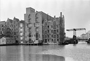 Rear facades with Peperbrug
 -
 Nieuwe Uilenburgerstraat 173–175. Boas Diamond polishing: view over the water


See also
- Canals of Amsterdam
Wikimedia Commons has media related to Uilenburgergracht.
Notes
- ^ a b "De Houtkopersburgwal". amsterdamsebinnenstad.nl (in Dutch). Retrieved 30 August 2013.
Sources
- v
- t
- e
Canals of Amsterdam
Excludes former canals that have since been filled in
- Damrak (partly filled up)
- Rokin (partly filled up)
- Amstel

- Oudezijds Kolk
- Oudezijds Voorburgwal
- Oudezijds Achterburgwal
- Grimburgwal
- Geldersekade
- Kloveniersburgwal
- Singel


