Vanderlin Island
Island of the Northern Territory, Australia
Vanderlin Island is an island in the Gulf of Carpentaria, Northern Territory, Australia. It is the largest island in the Sir Edward Pellew Group. Its area is 264 km2 (102 sq mi). The island is part of the traditional lands of the Walu people.
The only settlements on the island are four family outstations along the west coast. They are, from north to south:[1][2]
- Mooloowa
- Babungi
- Yulbara
- Uguie
Exact population figures are not known, but family outstations are typically four to six people, which results in a population of approximately 20 for the whole island. In 2019 only one family (Smith) of five persons lives on Vanderlin Island.[3]
Illustrations
-
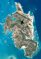 Landsat image of Vanderlin Island
 -
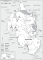 Sketch map of Vanderlin Island


See also
References
- v
- t
- e
Islands of the Northern Territory
- Bremer
- Burney
- Crocodile
- Milingimbi
- Croker Group
- Croker
- New Year
- East Woody
- Goulburn
- Groote Eylandt
- Bickerton
- Haul Round
- Higginson
- Howard
- Inglis
- Maria
- Peron
- Rimbija
- Sir Edward Pellew
- Centre
- Skull
- Vanderlin
- South West
- Sir George Hope Islands
- Three Hummocks
- Tiwi
- Bathurst
- Melville
- Seagull
- Warnawi
- Wessel
- Abbott
- Bumaga
- Cunningham
- Drysdale
- Elcho
- Marchinbar
- Quail
- Raragala
- Vernon Islands
- Woodah
 Category
 Commons

| ||
|---|---|---|
| Australian continent / Australian mainland |
|  |
| Queensland |
| |
| Northern Territory |
| |
| Western Australia |
| |
| South Australia |
| |
| Tasmania |
| |
| Related topics | ||
| ||
15°44′S 137°02′E / 15.733°S 137.033°E / -15.733; 137.033
 | This Northern Territory geography article is a stub. You can help Wikipedia by expanding it. |
- v
- t
- e


