Velence Hills
47°15′33″N 18°35′47″E / 47.259038°N 18.596496°E / 47.259038; 18.596496Elevation 352 m (1,155 ft) Geography 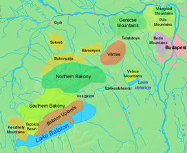

Country Hungary County Fejér County Geology Orogeny Transdanubian Mountains West-Hungarian Borderland 
Physico-geographical mesoregions of Hungary Little Hungarian Plain Transdanubia Transdanubian Mountains Transdanubian Hills North Hungarian
Mountains Great Hungarian Plain

Velence Hills (Hungarian: Velencei-hegység) is a low mountain range in north-western Hungary, in the Central Transdanubian region. It lies to the north of Lake Velence, some 15 km to the east of city of Székesfehérvár. The Velence Hills are part of the Transdanubian Mountains. Village of Nadap lies in the central part of the hills and is the point of departure of excursions to the countryside.[1] The highest point, Meleg-hegy ("Hot hill") (352 m) lies above the village.[2]
Gallery


References
External links
 Media related to Velence Hills at Wikimedia Commons
- v
- t
- e
Geographical regions of Hungary
- Alpokalja
- Kőszeg Mountains
- Sopron Mountains
- Vas Hills
- Balfi Hills

- Hanság
- Fertőzug
- Neusiedl Basin
- Rábaköz
- Szigetköz
- Marcal Basin
- Moson Plain
- Komárom-Esztergom Plain
- Baranya
- Zala Hills
- Inner Somogy
- Outer Somogy
- Zselic
- Völgység
- Szekszárd Hills
- Baranya Hills
- Villány Mountains
- Keszthely Mountains
- Tapolca Basin
- Balaton Uplands
- Bakony
- Bakonyalja
- Sokoró
- Vértesalja
- Velence Hills
- Gerecse Mountains
- Buda Hills
- Pilis Mountains
- Visegrád Mountains
- Vértes Mountains
- Mecsek
- Outer Somogy
- Inner Somogy
- Tolna-Baranya Hills
- Balaton Basin
Mountains
Authority control databases | |
|---|---|
| International |
|
| National |
|
 | This Fejér location article is a stub. You can help Wikipedia by expanding it. |
- v
- t
- e


