Étreval
Gemeente in Frankrijk  | |||
|---|---|---|---|
 | |||
  | |||
| Situering | |||
| Regio | Grand Est | ||
| Departement | Meurthe-et-Moselle (54) | ||
| Arrondissement | Nancy | ||
| Kanton | Meine au Saintois | ||
| Coördinaten | 48° 27′ NB, 6° 3′ OL | ||
| Algemeen | |||
| Oppervlakte | 2,37 km² | ||
| Inwoners (1 januari 2021) | 59[1] (25 inw./km²) | ||
| Hoogte | 265 - 328 m | ||
| Overig | |||
| Postcode | 54330 | ||
| INSEE-code | 54185 | ||
| Foto's | |||
 | |||
| |||

Étreval is een gemeente in het Franse departement Meurthe-et-Moselle (regio Grand Est) en telt 59 inwoners (2009). De plaats maakt deel uit van het arrondissement Nancy.
Geografie
De oppervlakte van Étreval bedraagt 2,3 km², de bevolkingsdichtheid is dus 25,7 inwoners per km².
De onderstaande kaart toont de ligging van Étreval met de belangrijkste infrastructuur en aangrenzende gemeenten.
 |
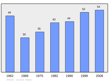
Demografie
De figuur toont het verloop van het inwonertal (bron: INSEE-tellingen).
Externe links
- (fr) Statistische informatie op de website van INSEE
Gemeenten in het kanton Meine au Saintois
Aboncourt · Affracourt · Allain · Allamps · Autrey · Bagneux · Bainville-aux-Miroirs · Barisey-au-Plain · Barisey-la-Côte · Battigny · Benney · Beuvezin · Blénod-lès-Toul · Bouzanville · Bralleville · Bulligny · Ceintrey · Chaouilley · Clérey-sur-Brenon · Colombey-les-Belles · Courcelles · Crantenoy · Crépey · Crévéchamps · Crézilles · Diarville · Dolcourt · Dommarie-Eulmont · Étreval · Favières · Fécocourt · Forcelles-Saint-Gorgon · Forcelles-sous-Gugney · Fraisnes-en-Saintois · Frolois · Gélaucourt · Gémonville · Gerbécourt-et-Haplemont · Germiny · Germonville · Gibeaumeix · Grimonviller · Gripport · Goviller · Gugney · Hammeville · Haroué · Houdelmont · Houdreville · Housséville · Jevoncourt · Lalœuf · Laneuveville-devant-Bayon · Lebeuville · Lemainville · Leménil-Mitry · Mangonville · Marthemont · Mont-l'Étroit · Mont-le-Vignoble · Moutrot · Neuviller-sur-Moselle · Ochey · Ognéville · Omelmont · Ormes-et-Ville · Parey-Saint-Césaire · Pierreville · Praye · Pulligny · Pulney · Quevilloncourt · Roville-devant-Bayon · Saint-Firmin · Saint-Remimont · Saulxerotte · Saulxures-lès-Vannes · Saxon-Sion · Selaincourt · Sexey-aux-Forges · Tantonville · Thélod · They-sous-Vaudemont · Thorey-Lyautey · Thuilley-aux-Groseilles · Tramont-Émy · Tramont-Lassus · Tramont-Saint-André · Uruffe · Vandeléville · Vannes-le-Châtel · Vaudémont · Vaudeville · Vaudigny · Vézelise · Viterne · Vitrey · Voinémont · Vroncourt · Xeuilley · Xirocourt
Mediabestanden
Zie de categorie Étreval van Wikimedia Commons voor mediabestanden over dit onderwerp.
- ↑ Populations légales 2021.


