Alpokalja
| Alpokalja | |
|---|---|
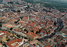 The city of Sopron is located in the range | |
| Location | Western Hungary |
| Territory | ? |
| Highest point | Írott-kő, 882 m |
| Terrain | mountainous |

Geographic region in western Hungary
Alpokalja (English "feet of the Alps") is a geographic region in western Hungary. Its highest point is Írott-kő at 882 metres above sea level. Although there are several lower mountains, the majority of the territory is hilly. Fir forests are characteristic to the region. Alpokalja contains two major but not very extensive mountain ranges: the Kőszeg Mountains and the Sopron Mountains. The Vas Hills and Balfi Hills are also considered part of the territory.
See also
- Geography of Hungary
- Little Alföld
- v
- t
- e
Geographical regions of Hungary
- Alpokalja
- Kőszeg Mountains
- Sopron Mountains
- Vas Hills
- Balfi Hills

- Hanság
- Fertőzug
- Neusiedl Basin
- Rábaköz
- Szigetköz
- Marcal Basin
- Moson Plain
- Komárom-Esztergom Plain
- Baranya
- Zala Hills
- Inner Somogy
- Outer Somogy
- Zselic
- Völgység
- Szekszárd Hills
- Baranya Hills
- Villány Mountains
- Keszthely Mountains
- Tapolca Basin
- Balaton Uplands
- Bakony
- Bakonyalja
- Sokoró
- Vértesalja
- Velence Hills
- Gerecse Mountains
- Buda Hills
- Pilis Mountains
- Visegrád Mountains
- Vértes Mountains
- Mecsek
- Outer Somogy
- Inner Somogy
- Tolna-Baranya Hills
- Balaton Basin
Mountains
| Authority control databases |
|
|---|
47°22′N 16°32′E / 47.367°N 16.533°E / 47.367; 16.533
 | This Hungarian geography article is a stub. You can help Wikipedia by expanding it. |
- v
- t
- e


