Montferland
Municipality in Gelderland, Netherlands
Flag

Coat of arms

Location in Gelderland
(January 2021)[6]
6940–6942, 7035–7048

Montferland (Dutch pronunciation: [ˈmɔntfərlɑnt] ⓘ) is a municipality in the Dutch province of Gelderland. It was created on 1 January 2005 from the amalgamation of the former municipalities of Bergh and Didam.
Population centres
Formerly part of Bergh municipality:
Formerly part of Didam municipality:
- Didam
- Greffelkamp
- Holthuizen
- Loil
- Nieuw-Dijk
- Oud-Dijk
Gallery
-
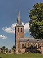 St Martin's church in Beek
 -
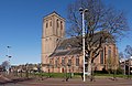 Didam church
 -
 Kilder church
 -
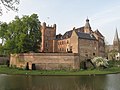 Huis Bergh castle in
's-Heerenberg -
 Düffels Möl in Stokkum
 -
 Windmill in Zeddam village


Notable people
- Willem IV van den Bergh (1537 in 's-Heerenberg – 1586) Stadtholder of Guelders and Zutphen
- Herman van den Bergh (1558 in 's-Heerenberg – 1611) a Dutch soldier in the Eighty Years' War
- Mechteld ten Ham (died 25 July 1605) an alleged Dutch witch in the city of 's-Heerenberg
- Everard Ter Laak (1868 in Didam - 1931) a Dutch Roman Catholic missionary in China
- Jozef Rulof (1898 in 's-Heerenberg – 1952) a Dutch author and psychic and trance medium or spirit medium
- Jos Som (born 1951 in Didam) a Dutch politician deputy Mayor of Didam
- Ernie Brandts (born 1956 in Nieuw-Dijk) a Dutch football manager and former player with 452 club caps
- Geert-Jan Derksen (born 1975 in Didam) a Dutch rower, silver medallist at the 2004 Summer Olympics
References
- ^ "Gemeentelijke indeling op 1 januari 2005" [Municipal divisions on 1 January 2005]. cbs.nl (in Dutch). CBS. Retrieved 10 July 2014.
- ^ "Samenstelling college" [Members of the board] (in Dutch). Gemeente Montferland. Retrieved 10 July 2014.
- ^ "Kerncijfers wijken en buurten 2020" [Key figures for neighbourhoods 2020]. StatLine (in Dutch). CBS. 24 July 2020. Retrieved 19 September 2020.
- ^ "Postcodetool for 6942GK". Actueel Hoogtebestand Nederland (in Dutch). Het Waterschapshuis. Retrieved 10 July 2014.
- ^ "Bergherbos in Montferland". Brockhausen. Retrieved 27 August 2020.
- ^ "Bevolkingsontwikkeling; regio per maand" [Population growth; regions per month]. CBS Statline (in Dutch). CBS. 1 January 2021. Retrieved 2 January 2022.
External links
Wikimedia Commons has media related to Montferland.
- Official website
Places adjacent to Montferland | ||||||||||||||||
|---|---|---|---|---|---|---|---|---|---|---|---|---|---|---|---|---|
| ||||||||||||||||


Authority control databases | |
|---|---|
| International |
|
| Geographic |
|
 | This Gelderland location article is a stub. You can help Wikipedia by expanding it. |
- v
- t
- e


