National Register of Historic Places listings in Clearwater County, Idaho
This is a list of the National Register of Historic Places listings in Clearwater County, Idaho.
This is intended to be a complete list of the properties and districts on the National Register of Historic Places in Clearwater County, Idaho, United States. Latitude and longitude coordinates are provided for many National Register properties and districts; these locations may be seen together in a map.[1]
There are 8 properties and districts listed on the National Register in the county, including 2 National Historic Landmarks. More may be added; properties and districts nationwide are added to the Register weekly.[2]
This National Park Service list is complete through NPS recent listings posted June 14, 2024.[3]
Map all coordinates using OpenStreetMap
Download coordinates as:
- KML
- GPX (all coordinates)
- GPX (primary coordinates)
- GPX (secondary coordinates)
Current listings
| [4] | Name on the Register[5] | Image | Date listed[6] | Location | City or town | Description |
|---|---|---|---|---|---|---|
| 1 | Brown's Creek CCC Camp Barracks | 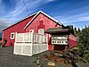 | July 5, 1984 (#84001114) | 105 1st St., E. 46°22′34″N 115°56′10″W / 46.376111°N 115.936111°W / 46.376111; -115.936111 (Brown's Creek CCC Camp Barracks) | Weippe | |
| 2 | Lolo Trail | 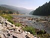 | October 15, 1966 (#66000309) | Parallel to U.S. Route 12 on ridges of the Bitterroot Mountains, from Lolo Pass to Weippe 46°38′00″N 114°34′46″W / 46.633333°N 114.579444°W / 46.633333; -114.579444 (Lolo Trail) | Weippe | |
| 3 | Moore Gulch Chinese Mining Site (10-CW-159) |  | January 27, 1983 (#83000285) | Address restricted[7] | Pierce | |
| 4 | Nez Perce National Historical Park |  | October 15, 1966 (#66000310) | Along U.S. Route 12 southeast of Kamiah[8] 46°12′39″N 116°00′00″W / 46.210781°N 116°W / 46.210781; -116 (Nez Perce National Historical Park) | Kamiah | One of several separate parts of the Park in Idaho, but the only one listed on the National Register |
| 5 | Orofino Historic District |  | October 29, 1982 (#82000384) | 2nd, Dewey, Main, Johnson, and 6th Sts. 46°28′32″N 116°15′06″W / 46.475538°N 116.251680°W / 46.475538; -116.251680 (Orofino Historic District) | Orofino | |
| 6 | Pierce Courthouse |  | November 3, 1972 (#72000100) | State Highway 11 46°29′25″N 115°47′53″W / 46.490200°N 115.798062°W / 46.490200; -115.798062 (Pierce Courthouse) | Pierce | |
| 7 | U.S. Post Office – Orofino Main | 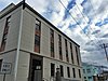 | March 16, 1989 (#89000133) | 320 Michigan Ave. 46°28′49″N 116°15′09″W / 46.480374°N 116.252591°W / 46.480374; -116.252591 (U.S. Post Office – Orofino Main) | Orofino | |
| 8 | Weippe Prairie | 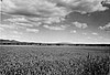 | October 15, 1966 (#66000311) | South of Weippe and State Highway 11 46°21′22″N 115°55′21″W / 46.356111°N 115.9225°W / 46.356111; -115.9225 (Weippe Prairie) | Weippe |
See also
Wikimedia Commons has media related to National Register of Historic Places in Clearwater County, Idaho.
References
- ^ The latitude and longitude information provided in this table was derived originally from the National Register Information System, which has been found to be fairly accurate for about 99% of listings. Some locations in this table may have been corrected to current GPS standards.
- ^ "National Register of Historic Places: Weekly List Actions". National Park Service. Retrieved March 29, 2009.
- ^ National Park Service, United States Department of the Interior, "National Register of Historic Places: Weekly List Actions", retrieved June 14, 2024.
- ^ Numbers represent an alphabetical ordering by significant words. Various colorings, defined here, differentiate National Historic Landmarks and historic districts from other NRHP buildings, structures, sites or objects.
- ^ "National Register Information System". National Register of Historic Places. National Park Service. April 24, 2008.
- ^ The eight-digit number below each date is the number assigned to each location in the National Register Information System database, which can be viewed by clicking the number.
- ^ Federal and state laws and practices restrict general public access to information regarding the specific location of this resource. In some cases, this is to protect archeological sites from vandalism, while in other cases it is restricted at the request of the owner. See: Knoerl, John; Miller, Diane; Shrimpton, Rebecca H. (1990), Guidelines for Restricting Information about Historic and Prehistoric Resources, National Register Bulletin, National Park Service, U.S. Department of the Interior, OCLC 20706997.
- ^ Location derived from Google Maps; the NRIS lists the site as "Area 90 miles south and 150 miles east of Spalding"
- v
- t
- e
- Ada
- Adams
- Bannock
- Bear Lake
- Benewah
- Bingham
- Blaine
- Boise
- Bonner
- Bonneville
- Boundary
- Butte
- Camas
- Canyon
- Caribou
- Cassia
- Clark
- Clearwater
- Custer
- Elmore
- Franklin
- Fremont
- Gem
- Gooding
- Idaho
- Jefferson
- Jerome
- Kootenai
- Latah
- Lemhi
- Lewis
- Lincoln
- Madison
- Minidoka
- Nez Perce
- Oneida
- Owyhee
- Payette
- Power
- Shoshone
- Teton
- Twin Falls
- Valley
- Washington

| |
|---|---|
| Topics | |
| Lists by state |
|
| Lists by insular areas | |
| Lists by associated state | |
| Other areas | |
| Related | |
| |


Municipalities and communities of Clearwater County, Idaho, United States | ||
|---|---|---|
County seat: Orofino | ||
| Cities | ||
| Unincorporated communities | ||
| Indian reservation | ||
| Footnotes | ‡This populated place also has portions in an adjacent county or counties | |
| ||


