National Register of Historic Places listings in Valley County, Idaho

This is a list of the National Register of Historic Places listings in Valley County, Idaho.
This is intended to be a complete list of the properties and districts on the National Register of Historic Places in Valley County, Idaho, United States. Latitude and longitude coordinates are provided for many National Register properties and districts; these locations may be seen together in a map.[1]
There are 26 properties and districts listed on the National Register in the county. More may be added; properties and districts nationwide are added to the Register weekly.[2]
This National Park Service list is complete through NPS recent listings posted June 7, 2024.[3]
Map all coordinates using OpenStreetMap
Download coordinates as:
- KML
- GPX (all coordinates)
- GPX (primary coordinates)
- GPX (secondary coordinates)
Current listings
| [4] | Name on the Register[5] | Image | Date listed[6] | Location | City or town | Description |
|---|---|---|---|---|---|---|
| 1 | Big Creek Commissary | Upload image | April 21, 2000 (#00000327) | Yellow Pine in the Payette National Forest 45°08′16″N 115°19′08″W / 45.137778°N 115.318889°W / 45.137778; -115.318889 (Big Creek Commissary) | Yellow Pine | |
| 2 | Braddock Gold Mining and Milling Company Log Building and Forge Ruins | Upload image | September 12, 1985 (#85002157) | Off Pack Trail near Suicide Rock 44°59′21″N 115°08′09″W / 44.989167°N 115.135833°W / 44.989167; -115.135833 (Braddock Gold Mining and Milling Company Log Building and Forge Ruins) | Thunder City | |
| 3 | Cabin Creek Ranch | Upload image | June 27, 1990 (#90000890) | Cabin Creek at its confluence with Big Creek in the Payette National Forest 45°08′14″N 114°56′01″W / 45.137222°N 114.933611°W / 45.137222; -114.933611 (Cabin Creek Ranch) | Black Butte | |
| 4 | Elo School |  | July 26, 1982 (#82002515) | Southeast of State Highway 55 on Farm to Market Rd. 44°53′10″N 116°03′34″W / 44.886111°N 116.059444°W / 44.886111; -116.059444 (Elo School) | McCall | |
| 5 | Matt N. Hill Homestead Barn |  | November 17, 1982 (#82000362) | Southeast of McCall 44°53′02″N 116°03′26″W / 44.883889°N 116.057222°W / 44.883889; -116.057222 (Matt N. Hill Homestead Barn) | McCall | |
| 6 | Thomas Jarvi Homestead | Upload image | November 17, 1982 (#82000363) | East of Lake Fork on Finn Rd. 44°49′58″N 116°04′49″W / 44.832778°N 116.080278°W / 44.832778; -116.080278 (Thomas Jarvi Homestead) | Lake Fork | |
| 7 | Johnson Flying Service Hangar |  | November 20, 2019 (#100004675) | 103 S. 3rd St. 44°53′51″N 116°05′47″W / 44.8976°N 116.0965°W / 44.8976; -116.0965 (Johnson Flying Service Hangar) | McCall | |
| 8 | John G. Johnson (Rintakangas) Homestead |  | November 17, 1982 (#82000364) | Northeast of Lake Fork off Pearson Rd. 44°52′01″N 116°02′56″W / 44.866944°N 116.048889°W / 44.866944; -116.048889 (John G. Johnson (Rintakangas) Homestead) | Lake Fork | |
| 9 | John S. Johnson (Sampila) Homestead |  | November 17, 1982 (#82000365) | Northeast of Lake Fork off Pearson Rd. 44°51′40″N 116°03′33″W / 44.861111°N 116.059167°W / 44.861111; -116.059167 (John S. Johnson (Sampila) Homestead) | Lake Fork | |
| 10 | John Korvola Homestead |  | November 17, 1982 (#82000366) | Roseberry Rd. and Farm to Market Rd. 44°44′12″N 116°04′20″W / 44.736667°N 116.072222°W / 44.736667; -116.072222 (John Korvola Homestead) | Donnelly | |
| 11 | Charles Koski Homestead |  | November 17, 1982 (#82000367) | Southeast of McCall 44°53′16″N 116°05′03″W / 44.887778°N 116.084167°W / 44.887778; -116.084167 (Charles Koski Homestead) | McCall | |
| 12 | Krassel Ranger Station | Upload image | November 19, 1992 (#92000688) | Along the South Fork of the Salmon River, 11 miles west of Yellow Pine, in the Payette National Forest 44°58′14″N 115°43′53″W / 44.970556°N 115.731389°W / 44.970556; -115.731389 (Krassel Ranger Station) | Yellow Pine | |
| 13 | Gust Laituri Homestead | 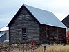 | November 17, 1982 (#82000368) | Northeast of Lake Fork off Pearson Rd. 44°51′40″N 116°04′41″W / 44.861111°N 116.078056°W / 44.861111; -116.078056 (Gust Laituri Homestead) | Lake Fork | |
| 14 | Long Valley Finnish Church |  | May 27, 1980 (#80001336) | Southeast of Lake Fork 44°49′05″N 116°02′46″W / 44.818056°N 116.046111°W / 44.818056; -116.046111 (Long Valley Finnish Church) | Lake Fork | |
| 15 | Jacob and Herman Mahala Homestead |  | November 17, 1982 (#82000369) | North of Donnelly 44°43′55″N 116°02′42″W / 44.731944°N 116.045°W / 44.731944; -116.045 (Jacob and Herman Mahala Homestead) | Donnelly | |
| 16 | Jacob Maki Homestead |  | November 17, 1982 (#82001053) | Off State Highway 55 44°49′19″N 116°05′53″W / 44.821944°N 116.098056°W / 44.821944; -116.098056 (Jacob Maki Homestead) | Donnelly | |
| 17 | McCall District Administrative Site |  | December 30, 1991 (#91001892) | Junction of W. Lake and Mission Sts. 44°54′35″N 116°06′21″W / 44.909722°N 116.105833°W / 44.909722; -116.105833 (McCall District Administrative Site) | McCall | |
| 18 | North Fork Payette River Bridge | 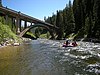 | April 2, 1999 (#99000416) | State Highway 55, approximately 2.5 miles north of Smiths Ferry 44°19′32″N 116°03′30″W / 44.325556°N 116.058333°W / 44.325556; -116.058333 (North Fork Payette River Bridge) | Smiths Ferry | |
| 19 | Herman Ojala Homestead | Upload image | November 17, 1982 (#82000370) | Northeast of Lake Fork off Pearson Rd. 44°51′58″N 116°04′48″W / 44.866111°N 116.08°W / 44.866111; -116.08 (Herman Ojala Homestead) | Lake Fork | |
| 20 | Payette Lakes Club |  | April 24, 2017 (#100000905) | 1858 Warren Wagon Rd. 44°55′26″N 116°07′40″W / 44.923953°N 116.127688°W / 44.923953; -116.127688 (Payette Lakes Club) | McCall | |
| 21 | Rice Meetinghouse |  | April 9, 1980 (#80001337) | Northeast of McCall 44°55′46″N 116°03′50″W / 44.929444°N 116.063889°W / 44.929444; -116.063889 (Rice Meetinghouse) | McCall | |
| 22 | Matt Ruatsale Homestead |  | November 17, 1982 (#82000371) | North of Kantola Lane 44°49′42″N 116°02′44″W / 44.828333°N 116.045556°W / 44.828333; -116.045556 (Matt Ruatsale Homestead) | Lake Fork | |
| 23 | Southern Idaho Timber Protective Association (SITPA) Buildings |  | May 2, 1990 (#90000680) | 1001 State St. 44°54′35″N 116°06′29″W / 44.909722°N 116.108056°W / 44.909722; -116.108056 (Southern Idaho Timber Protective Association (SITPA) Buildings) | McCall | |
| 24 | Southern Idaho Timber Protective Association (SITPA) Buildings | 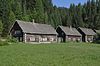 | May 2, 1990 (#90000681) | State Highway 55 44°18′04″N 116°05′21″W / 44.301111°N 116.089167°W / 44.301111; -116.089167 (Southern Idaho Timber Protective Association (SITPA) Buildings) | Smiths Ferry | |
| 25 | Stibnite Historic District |  | July 19, 1987 (#87001186) | United States Forest Service Road 412 44°54′39″N 115°20′17″W / 44.910833°N 115.338056°W / 44.910833; -115.338056 (Stibnite Historic District) | Yellow Pine | |
| 26 | Nickolai Wargelin Homestead |  | November 17, 1982 (#82000372) | Southeast of McCall 44°53′03″N 116°04′05″W / 44.884167°N 116.068056°W / 44.884167; -116.068056 (Nickolai Wargelin Homestead) | McCall |
Former listings
| [4] | Name on the Register | Image | Date listed | Date removed | Location | City or town | Description |
|---|---|---|---|---|---|---|---|
| 1 | Brown Tie and Lumber Company Mill and Burner | Upload image | December 20, 1978 (#78001103) | January 31, 1986 | Off ID 55 at Payette Lake | McCall | Destroyed by fire. |
See also
Wikimedia Commons has media related to National Register of Historic Places in Valley County, Idaho.
References
- ^ The latitude and longitude information provided in this table was derived originally from the National Register Information System, which has been found to be fairly accurate for about 99% of listings. Some locations in this table may have been corrected to current GPS standards.
- ^ "National Register of Historic Places: Weekly List Actions". National Park Service. Retrieved March 29, 2009.
- ^ National Park Service, United States Department of the Interior, "National Register of Historic Places: Weekly List Actions", retrieved June 7, 2024.
- ^ a b Numbers represent an alphabetical ordering by significant words. Various colorings, defined here, differentiate National Historic Landmarks and historic districts from other NRHP buildings, structures, sites or objects.
- ^ "National Register Information System". National Register of Historic Places. National Park Service. April 24, 2008.
- ^ The eight-digit number below each date is the number assigned to each location in the National Register Information System database, which can be viewed by clicking the number.
- v
- t
- e
- Ada
- Adams
- Bannock
- Bear Lake
- Benewah
- Bingham
- Blaine
- Boise
- Bonner
- Bonneville
- Boundary
- Butte
- Camas
- Canyon
- Caribou
- Cassia
- Clark
- Clearwater
- Custer
- Elmore
- Franklin
- Fremont
- Gem
- Gooding
- Idaho
- Jefferson
- Jerome
- Kootenai
- Latah
- Lemhi
- Lewis
- Lincoln
- Madison
- Minidoka
- Nez Perce
- Oneida
- Owyhee
- Payette
- Power
- Shoshone
- Teton
- Twin Falls
- Valley
- Washington

| |
|---|---|
| Topics | |
| Lists by state |
|
| Lists by insular areas | |
| Lists by associated state | |
| Other areas | |
| Related | |
| |


